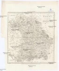
Maps of Bavaria

Baiern mit Ausschluss des Rheinkreises
1 : 1154000 Bavorsko (Německo) Berthe Gleditsch
Geschäfts-Uebersichtskarte des Steuer-Katasters bis zum Schlusse des Jahres 18..
1 : 800000 K. Stiglmayer Contur gravirt J. Obernetter Schrift gravirt [S.l.] : [s.n.]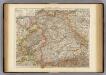
Wurtemberg, Bavaria.
1 : 1000000 Andree, Richard; Times (London, England)
Chur-Bayern im Jahr 1804
1 : 1083000 Bavorsko (Německo) Herdegen, J. C. F. Leizel, Balthasar Friedrich J.L.C. Rheinwald
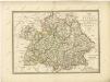
Germany south.
1 : 1840000 Arrowsmith, Aaron; Lewis, Samuel
Germany south.
1 : 1840000 Arrowsmith, Aaron; Lewis, Samuel
Das Königreich Baiern nach Mannert und andern vorzüglichen Hülfsmitteln
1 : 690000 Bavorsko (Německo) Dirwald, Joseph Mannert, Conrad T. Mollo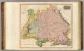
Germany S. of Mayne.
1 : 860000 Thomson, John
Königreich Bayern
1 : 1240000 Bavorsko (Německo) Mollo, Tranquillo bey Tranquillo Mollo
Composite: Bayern.
1 : 650000 Radefeld, Carl Christian Franz, 1788-1874
Bayern, Wurtemberg, Baden, Hohenzollern.
1 : 1800000 Reichard, C. G.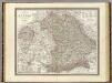
Bayern.
1 : 850000 Weiland, C. F. (Carl Ferdinand), d. 1847
Das Königreich Bayern
1 : 860000 Bavorsko (Německo) Weiland, Karl Ferdinand Gräf, A. Geographisches Institut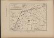
Cesta, kudy Hus ubíral se do Kostnice
Mitteleuropa Konstanz Reiseweg Hus, Jan
Bayern.
1 : 1390000 Flemming, Carl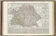
Regni di Baviera, Wurttemberg, Baden, Principati Prussiani.
1 : 2200000 Wieland, C. F.
Postkarte von Bayern, Würtemberg und Baden nebst Theilen der angrenzenden Laender
Bavorsko (Německo) Loehle, Franz Franz Loehle
Königreich Bayern Bezirksämter 1862
Bayern Bezirksamt Kunz, Andreas ; Johnen, Bettina ; Moeschl, Joachim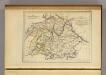
La Baviere, le Wurtemberg, et le Gr. Duche de Bade
1 : 2000000 Malte-Brun, Conrad, 1775-1826
Germany Southern.
1 : 1000000 Hall, S. (Sidney)
Neueste Karte von Bayern Würtemberg, Baden und Hohenzollern
Grosser Hand-Atlas über alle Theile der Erde in 170 Karten Meyer, J. Verlag des Bibliographischen Instituts
Das Konigreich Bayern
1 : 850000 Weiland, C.F.
Germany.
1 : 1500000 Colton, G.W.
Königreich Bayern Kreisunmittelbare Städte 1862
Bayern Kreisfreie Stadt Kunz, Andreas ; Johnen, Bettina ; Moeschl, Joachim
Baiern, Wurtemberg, Baden u. Hohenzollern.
1 : 980000 Streit, F. W.
Salisbvrgensis Ivrisdictionis, locorumque vicinorum vera descriptio
1 : 730000 Mollova mapová sbírka Setznagel, Marx Rade, Gillis van den
Germany.
1 : 1500000 Colton, G.W.
Südwestliches Deutschland
Neuer Handatlas über alle Theile der Erde Kiepert, Heinrich Verlag von Dietrich Reimer
Chur-Bayern im Jahr 1802
1 Karte : Kupferdruck ; 39 x 43 cm Rheinwald; Herdegen; Leizel s.n.