Maps of Ionian Islands Region

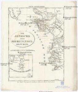
Die Jonische oder Siebeninsel Republik
1 : 1525000 Egejské moře (oblast) Gleditsch
Ionian Islands, Malta.
1 : 411840 Stanford, Edward
Epirus, hodie vulgò Albania. [Karte], in: Novus atlas absolutissimus, Bd. 10, S. 82.
1 Karte aus Atlas Janssonius Offizin
Insulae Maris Ionii. [Karte] , in: Theatrum orbis terrarum, S. 520.
1 Karte aus Atlas Ortelius, Abraham Vrients, Jan Baptista
Insulae Mari Ionii. [Karte], in: Theatrum orbis terrarum, S. 416.
1 Karte aus Atlas Ortelius, Abraham
Carte des écoles et des églises grecques de l'Epire
1 : 500000 Athènes :
Carte des écoles et églises du vilayet de Jannina (1908)
Griechenland Vilâyet Yanya Osmanisches Reich Kirchenbau Schulgebäude Kümmerly & Frey
Vera designatio insulae Corcyrae, Portus & Munitionum vera cum parte Epriri Accomodata ad Nostra Tempora. [Karte], in: Geographia universalis vetus et nova complectens Claudii Ptolemaei Alexandrini enarrationis libros VIII, S. 237.
1 Karte aus Atlas Münster, Sebastian [und Ptolemaeus, Claudius]
Nieuwe afteekening van 't eijland Corfu geleegen in de Middelantsche Zee in t incoomen van de Golf van Venetia
Greece Gerard van Keulen

Insularum Aliquot Maris Mediterranei Descriptio. [Corfu.] [Karte], in: Theatrum orbis terrarum, S. 240.
1 Karte aus Atlas Ortelius, Abraham
Insularum Aliquot Maris Mediterranei Descriptio. [Corfu.] [Karte], in: Theatrum orbis terrarum, S. 335.
1 Karte aus Atlas Ortelius, Abraham Vrients, Jan Baptista
Nova et accurata geographica tabula insulae Corfu seu Corcyrae cum confiniis suis, ac portubus ex adverso in Graecia jacentibus
1 : 150000 autore Joachimo Ottens Amstelodamensi Te Amsterdam : by Joachim Ottens [...]
Insularum Aliquot Maris Mediterranei Descriptio. [Corfu.] [Karte], in: Theatrum orbis terrarum, S. 91.
1 Karte aus Atlas Ortelius, Abraham
Korfu
1 : 1000000 Korfu
Candia cum Insulis aliquot circa Graeciam[:] [Zante] [Karte], in: Gerardi Mercatoris et I. Hondii Newer Atlas, oder, Grosses Weltbuch, Bd. 2, S. 336.
1 Karte aus Atlas Mercator, Gerhard und Hondius, Jodocus Jansson, Jan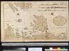
Het eijland St. Maura met alle dessels havenen geleegen aen de kust van Grecia in de Middelandse Zee aen de Oost sijde vant incomen van de Golf v. Venetia
Greece Gerard van Keulen
Candia cum Insulis aliquot circa Graeciam[:] [Corfu] [Karte], in: Gerardi Mercatoris et I. Hondii Newer Atlas, oder, Grosses Weltbuch, Bd. 2, S. 336.
1 Karte aus Atlas Mercator, Gerhard und Hondius, Jodocus Jansson, Jan
Plan de la ville de Corfu, assiegée par les Tures avec 35 000 hommes le 21 aoust. 1716 et extremement defendues par le general Schuytent
1 : 13000 Korfu, ostrov (Řecko) Visscher, Nicolaus Nicol. Visser
Vogliono alcuni che l'Isola di Corfú fosse prima da Sisifo latrone figliolo di Eolo habitata, et domandata da lui Corcira
Korfu, ostrov (Řecko) Bertelli, Ferdinando Fer[n]a[n]do Berteli
Korfu
1 : 400000 Griechenland Korfu
Candia cum Insulis aliquot circa Graeciam[:] [Corfu] [Karte], in: Gerardi Mercatoris Atlas, sive, Cosmographicae meditationes de fabrica mundi et fabricati figura, S. 493.
1 Karte aus Atlas Mercator, Gerhard Montanus, Petrus
Plan der Ebene Von Ianina in Albanien
Ioannina Barbié du Bocage, Jean Denis
Plan de la place du Corfu avec ses environs, assiegee par les infideles tranchee ouverte le 25me de iuillet jusqu'au 22 d' out. iour, de la fuite des Ottomans, defendüe par S. E. le Feldt Marechal Comte de Schulembourg, general en chef armées de la Ser. Rep[ubli]que de Veniseen l'an 1716
1 : 190000 Korfu (Řecko) Homann, Johann Baptist Schulenburg, Matthias Johann von der Iean Baptise Homann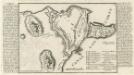
Corfu.
1 : 5000 Mollova mapová sbírka Bodenehr, Gabriel Bodenehr, Gabriel
Schema k opisanīju osady i vzjatija Korfu
Griechenland Korfu Seeschlacht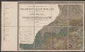
Candia cum Insulis aliquot circa Graeciam[:] [Zante] [Karte], in: Gerardi Mercatoris Atlas, sive, Cosmographicae meditationes de fabrica mundi et fabricati figura, S. 493.
1 Karte aus Atlas Mercator, Gerhard Montanus, Petrus
[Die Balkan-Halbinsel, Blatt 3]
Adolf Stieler's Handatlas über alle Theile der Erde und über das Weltgebäude Stieler, Adolf Justus Perthes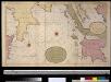
Het incomen van de Golf van Venetien vertoonende de Zuijdcust van Cicilia, Calabrian, Griekenland en Morea int groodt seer naeukeurig opgesteld
Italy Gerard van Keulen