Maps of Franz Josef Land

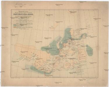
Předběžná mapa skupiny ostrovů, známé pod názvem Země Františka Josefa
1 : 5000000 arktická oblast Nansen, Fridtjof Jackson, Frederick George nákladem J. Otty
Nouvelle carte des isles de Spizbergue et des environs
1 Karte : Kupferdruck ; 40 x 55 cm Engel; Holzhalb Franz Samuel Fetscherin
Carte Generale de la Russie d'Asie ou Siberie.
1 : 14300000 Vivien de St Martin, L.
Cesta norské výpravy na severní točnu 1893-1896
1 : 12000000 Arktida nákladem J. Otty
Charte von America
Amerika Kitschin, Thomas Berra, Marco

Russie D'Europe, Empire Russe.
Andriveau-Goujon, J.
Charte von America
1 Karte : Kupferdruck ; 58 x 48 cm Walch bey Johannes Walch
Uebersichts-Karte der ethnographischen Verhältnisse von Asien und von den angrenzenden Theilen Europa'sbearbeitet und herausgegeben mit Unterstützung der kaiserlichen Akademie der Wissenschaften in Wien von Vinzenz v. Haardt
Hartenthurn, Vincenz
General chart exhibiting the discoveries of the Northmen in the arctic regions and America during the 10th., 11th., 12th., 13th., and 14th., centuries.
Severní Amerika Rafn, Carl Christian Behaim, Martin by the Royal society of northern antiquaries
Spesielle kart 152: Norge med biland og tilgrensende land- og havmområder
1 : 6000000 Gauss KrÃ1⁄4ger Norsk Polarinstitutt | Norges geografiske oppmÃ¥ling | Norges Sjà ̧kartverk
Arctic Regions.
Fullarton, A. & Co.
Karte von Kleinasien in 24 Blatt. Massstab 1:400,000. Bearbeitet von Dr. Richard Kiepert. Berlin Dietrich Reimer (Ernst Vohsen). 1904-1907. / bearbeitet von Richard Kiepert. 1902-1916.
From 1st Edition, 1:400,000. 1904-1907.
Sovětský svaz v mapách

Carte des glaces boreales.
1 : 34000000 Vincent
Elementary Map.
1 : 26611200 Melish, John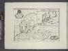
A new map of ancient Scandinavia, together with as much more of ye northern part of ancient Europe as answers to present Denmark & Moscovia.
from A new sett of maps both of antient and present geography : wherein not only the latitude and longitude of many places are corrected according to the latest observations, but also the most remarkable differences of antient and present geography may be quickly discern'd by a bare inspection or comparing of correspondent maps, which seems to be the most natural and easy method to lead young students (for whose use the work is principally intended) unto a competent knowledge of the geographical science : together with a geographical treatise particularly adapted to the use and design of these maps / by Edward Wells, M.A. and student of Christ-Church, Oxon.
Europe.
1 : 20275200 Melish, John
REGIONES | SVB POLO ARCTICO
Auctore Guiljelmo Blaeu [Amsterdam : Joan Blaeu]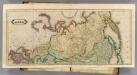
Asia. (N sheets)
1 : 12000000 Lizars, Daniel
Northern America.
1 : 17500000 Colton, G.W.
Amerique Russe, regions polaires boreales.
1 : 13000000 Garnier, F. A., 1803-1863
Russland, Italien, Balkan u. Orient, uit: Zu den grossen Offensive im Westen ; Russland, Italien, Balkan und Orient / bearb. und hrsg. von Walter Paasche
titelvariant: Russland, Italien, Balkan und Orient Walter Paasche Stuttgart : Paasche & Luz
Nova Et Accurata Poli Arctici et terrarum Circum Iacentium Descriptio. [Karte], in: Novus atlas absolutissimus, Bd. 9, S. 55.
1 Karte aus Atlas Janssonius Offizin
Fysikální mapa severních polárních zemí
1 : 14000000 Arktida Bartholomew, J. G. Nansen, Fridtjof nákladem J. Otty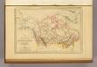
Amerique Russe, Nouvelle Bretagne et Canada.
1 : 23000000 Malte-Brun, Conrad, 1775-1826
Scandinavia, comprehending Norway, Sueden, and part of Denmark.
from New & accurate description of the earth in all its empires, kingdoms and states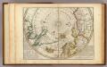
Map of the North Pole and territories near it.
1 : 26000000 Moll, Herman, d. 1732