Maps of Victoria

New Zealand
1 : 1415000 Auckland (Nový Zéland) Bacon, George Washington G.W. Bacon
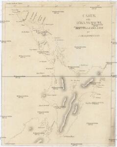
CARTE de l'Ille D'IKA NA MAUWI
Severní ostrov (Nový Zéland) Blosseville, Jules de Eyries, Jean-Baptiste Benoît J.B. Eyries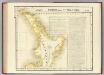
Partie, Nle. Zelande. Oceanque. no. 59.
1 : 1641836 Vandermaelen, Philippe, 1795-1869
238. New Zealand, New Caledonia, Fiji. The World Atlas.
1 : 5000000 USSR (Union of Soviet Socialist Republics).
Victoria Or Port Phillip.
1 : 2977920 Tallis, J. & F.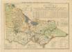
State of Victoria
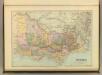
Victoria.
1 : 1900800 Stanford, Edward
Victoria.
1 : 2150000 Hughes, William
Gobernacion de Neuquen.
1 : 1800000 Paz Soldan, Mariano Felipe, 1821-1886
Gobernacion de La Pampa.
1 : 2470000 Paz Soldan, Mariano Felipe, 1821-1886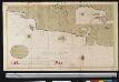
Een gedeelte van de kust van Chili in de Zuijd Zee van Po. IJtata tot El Laguia of van 36 tot 41 graden Breete
Chile Gerard van Keulen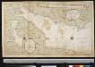
Afteekening van Rio de La Plata aen t Zuijd Eijnde van Brasilia na een Spaanse afteekening
Argentina Gerard van Keulen
Afteekening van het incomen van Rio de La Plata met alle desselfs gronden en banken tot voor Boinos Airos
Argentina Gerard van Keulen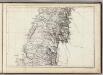
(Mapa de la Republica de Chile 6)
1 : 11000000 Pissis, Aime, 1812-1889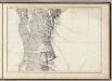
(Mapa de la Republica de Chile 7)
1 : 11000000 Pissis, Aime, 1812-1889
Partie, (Chili, la Plata). Amer. Merid. 36.
1 : 1641836 Vandermaelen, Philippe, 1795-1869
Partie, la Plata. Amer. Merid. 37.
1 : 1641836 Vandermaelen, Philippe, 1795-1869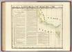
Partie, Nouvelle Hollande. Oceanique no. 56.
1 : 1641836 Vandermaelen, Philippe, 1795-1869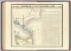
Partie, Nouvelle Hollande. Oceanique no. 57.
1 : 1641836 Vandermaelen, Philippe, 1795-1869
Coupes du continent Sud Americain.
1 : 2500000 Martin de Moussy, V. (Victor), 1810-1869
Departamento de tierras y colonizacion
1 : 1000000 (Chili) Servicio de Mensura y Clasificacion de Tierras Santiago du Chili : Taller del Servicio de Mensura y Clasificacion de Tierras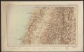
Republica de Chile [35°-37° S]
1 : 500000 (Chili) Oficina de Mensura de Tierras Santiago du Chili : Oficina de Mensura de Tierras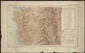
Republica de Chile [37°-39° S]
1 : 500000 (Chili) Oficina de Mensura de Tierras Santiago du Chili : Oficina de Mensura de Tierras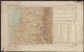
Republica de Chile [39°-41° S]
1 : 500000 (Chili) Oficina de Mensura de Tierras Santiago du Chili : Oficina de Mensura de Tierras
Demarcacion de limites con Chile. Plano general de la sub-comision n°3
1 : 500000 Argentine. Oficina de Límites Internacionales [Buenos Aires ?] :
Demarcacion de limites con Chile. Plano general de la sub-comision n°4
1 : 500000 Argentine. Oficina de Límites Internacionales [Buenos Aires ?] :
Plan of country between River Murray and Pinnaroo railway
1 : 250000 Surveyor General's Office
Demarcacion de limites con Chile. Plano general de la sub-comision n°5
1 : 500000 Argentine. Oficina de Límites Internacionales [Buenos Aires ?] :
Gobernacion del Neuquen
1 : 1400000 Seelstrang, Arthur Eduard von 1838-1896 Buenos-Aires : J. Ruland