Maps of District of Spišská Nová Ves

N. Ves a Vondrišel
1 : 75000 Slovensko Kartografické odd. při Min. nár. obrany
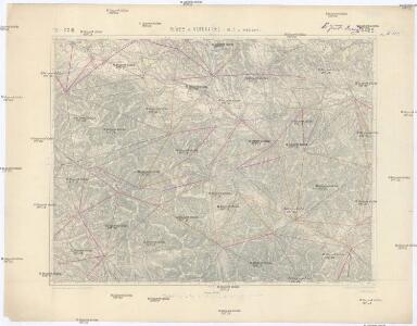
Igló und Merény
1 : 75000 Slovensko Militärgeographisches Institut
Igló und Wagendrüssel
1 : 75000 Spišská Nová Ves, Nálepkovo Schrift u. Gerippe v. Linhardt. Terrainschraffirung v. Hptm. Kafka
III. vojenské mapování 4465
1 : 75000
Spišská Nová Ves
1 : 75000 Slovensko Vojenský zeměpisný ústav
Spišská Nová Ves
1 : 75000 Slovensko Vojenský zeměpisný ústav
Spišská Nová Ves
1 : 75000 Slovensko Vojenský zeměpisný ústav
[Gradkartenblatt]
1 : 25000 Slovensko Vojenský zeměpisný ústav
[Gradkartenblatt]
1 : 25000 Slovensko
III. vojenské mapování 4465/4
1 : 25000
[Gradkartenblatt]
1 : 25000 Slovensko Vojenský zeměpisný ústav
[Gradkartenblatt]
1 : 25000 Slovensko Vojenský zeměpisný ústav
III. vojenské mapování 4465/3
1 : 25000
[Kartenblatt]
1 : 25000 Slovensko Reichsamt für Landesaufnahme
[Kartenblatt]
1 : 25000 Slovensko Reichsamt für Landesaufnahme
[Gradkartenblatt]
1 : 25000 Slovensko Vojenský zeměpisný ústav
[Gradkartenblatt]
1 : 25000 Slovensko
[Kartenblatt]
1 : 25000 Slovensko Reichsamt für Landesaufnahme
[Gradkartenblatt]
1 : 25000 Slovensko Vojenský zeměpisný ústav
[Gradkartenblatt]
1 : 25000 Slovensko
III. vojenské mapování 4465/1
1 : 25000
III. vojenské mapování 4465/2
1 : 25000
Iglo und Mereny.
from Spezialkarte der osterreichisch-ungarischen Monarchie.
Slovenský raj

Levoča a okolí
1 : 75000 Levoča (Slovensko : oblast) Vojenský zeměpisný ústav
[Kartenblatt]
1 : 25000 Slovensko Reichsamt für Landesaufnahme
Deutsches Volksgebiet in der Zips
Zips ethnische Gruppe, Deutsche
Kirchen, Klöster und Burgen in spätromanischer Zeit (nach V. Mancl)
Zips Baudenkmal