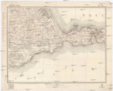
Maps of Kerch

Spec. karta Ukrainy
1 : 420000 Krym (Ukrajina) vidannja Kartografičnogo vyddilu golovnoji geodezyčnoji upravy
Caucausus & Crimea.
1 : 5000000 Fullarton, A. & Co.
Crimea o penisola Taurica
1 : 600000 Marzolla, Benedetto [Verlag nicht ermittelbar]
Specialkarte der Halbinsel Krymm
1 : 350000 entworfen und gezeichnet von F. Handtke Glogau : Flemming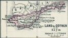
Land der Gothen in der Krym
1 : 2500000 Krim Goten
Plan osady krěposti Anapy v 1828 gódu
1 : 30000
Plan krěposti Anapy
Russland Anapa Seeschlacht
Crimea.
1 : 665000 Mitchell, Samuel Augustus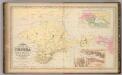
Crimea.
1 : 665000 Mitchell, Samuel Augustus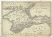
Karte der Krym oder des Taurischen Chersones
1 : 1070000 Krym (Ukrajina) J.J. Weber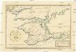
Post Karte von der Halbinsel Taurien oder Krim
1 : 1000000 Krym (Ukrajina) Benedicti, Hieronymus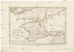
Post Karte von der Halbinsel Taurien oder Krim
1 : 1000000 Krym (Ukrajina) Benedicti, Hieronymus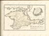

Die Krymm
1 : 1680000 Feodosija (Ukrajina) Flemming, Karl druck u. Verlag v. C. Flemming
Die Krymm
1 : 680000 Anapa (Rusko) Flemming, C. C. Flemming
Karte der Krim
1 : 1484000 Krym (Ukrajina) Leopold Sommer
Die Krymm [i.e. Krim]
1 : 1680000 Druck u. Verlag v. C. Flemming
Tavrie
Azovské moře-oblast (Ukrajina a Rusko)
Nova mappa geographica maris Assoviensis vel de Zabache et paludis Mæotidis
1 Karte : Kupferdruck ; 47 x 56 cm Seutter Matthäus Seutter
Karte Tauriens oder der Halbinsel Krim und der westlichen Nogayischen Tatarei
1 : 760000 Krym (Ukrajina) Schmidt, Jacob Friedrich Schraembl, Franz Anton F.A. Schraembl
Karte Tauriens oder der Halbinsel Krim und der westlichen nogayischen Tatarei
1 : 763000 Krym (Ukrajina) Schmidt, Jacob Friedrich Schraembl, Franz Anton F.A. Schraembl
Crimée
Nouvel atlas physique politique et historique de l'Empire ottoman et des états limitrophes en Europe, en Asie et en Afrique, en quarante feuilles Hellert, J.J. Bellizard, Dufour et Cie
Verus chersonesi Tauricae seu Crimeae conspectus adjacentium item regionum / editus ex autographis C
1 : 970000 1 Karte : Kupferdruck ; 46 x 65 cm Frauendorff, Carl von apud R. & I. Ottens
Verus chersonesi Tauricae seu Crimeae conspectus adjacentium item regionum / editus ex autographis C
1 : 970000 1 Karte : Kupferdruck ; 46 x 65 cm Frauendorff, Carl von apud Joan Block
Post Karte von der Halbinsel Taurien oder Krim / H. Benedicti sc
1 : 1100000 1 Karte : Kupferdruck ; 27 x 41 cm Benedicti, Hieronymus
Carte de la Mer d'Azof et d'une partie de la Mer Noire / levée en 1774 par Monsieur Kinsbergen, Cap
1 : 1600000 1 Karte : Kupferdruck ; 19 x 45 cm Kinsbergen, Jan Hendrik van Froullé
Carte de la Crimée
1 : 1900000 1 Karte : Kupferdruck ; 17 x 21 cm Bellin, Jacques Nicolas [Bellin]
Halbinsel Krymm
Grosser Hand-Atlas über alle Theile der Erde in 170 Karten Meyer, J. Verlag des Bibliographischen Instituts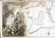
Carte de la mer noire et de la mer d'Asow, 1
1 Blatt : 57 x 86 cm s.n.