Maps of gmina Izbicko

Oppeln
1 : 75000 Opole (Polsko) K. u. k. Militärgeographisches Institut
Meßtischblatt 5374 : Kranst, 1938
1 : 250000 Kranst. - Hrsg. 1883, einz. Nachtr. 1929, red. Änd. [19]38. - 1:25000. - [Berlin]: Reichsamt für Landesaufnahme, 1938. - 1 Kt.
Meßtischblatt 5474 : Gr. Stein, 1938
1 : 250000 Gr. Stein. - Hrsg. 1883, einz. Nachtr. 1929, gedr. [19]38. - 1:25000. - [Berlin]: Reichsamt für Landesaufnahme, 1938. - 1 Kt.
Meßtischblatt 5375 : Malapane, 1939
1 : 250000 Malapane. - Aufn. 1881, hrsg. 1883, bericht. 1939. - 1:25000. - [Berlin]: Reichsamt für Landesaufnahme, 1939. - 1 Kt.
Meßtischblatt 5475 : Gr. Strehlitz, 1937
1 : 250000 Gr. Strehlitz. - Hrsg. 1883, einz. Nachtr. 1937. - 1:25000. - [Berlin]: Reichsamt für Landesaufnahme, 1937. - 1 Kt.
Meßtischblatt 3199 : Gr. Strehlitz, 1912
1 : 250000 Gr. Strehlitz. - Aufn. 1881, hrsg. 1883, gedr. [19]12. - 1:25000. - [Berlin]: Reichsamt für Landesaufnahme, 1912. - 1 Kt.
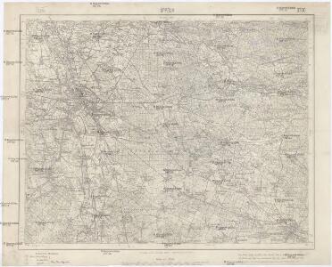
Meßtischblatt 5373 : Oppeln, 1941
1 : 250000 Oppeln. - Hrsg. 1883, bericht. 1939, Ausg. 1941. - 1:25000. - [Berlin]: Reichsamt für Landesaufnahme, 1941. - 1 Kt.
Meßtischblatt 3142 : Oppeln, 1936
1 : 250000 Oppeln. - Hrsg. 1883, einz. Nachtr. 1930, gedr. [19]36. - 1:25000. - [Berlin]: Reichsamt für Landesaufnahme, 1936. - 1 Kt.
Meßtischblatt 5473 : Proskau, 1941
1 : 250000 Proskau. - Aufn. 1881, hrsg. 1883, bericht. 1939, Ausg. 194. - 1:25000. - [Berlin]: Reichsamt für Landesaufnahme, 1941. - 1 Kt.
Meßtischblatt 5274 : Königshuld, 1938
1 : 250000 Königshuld. - Hrsg. 1883, einz. Nachtr. 1929, red. Änd. [19]38. - 1:25000. - [Berlin]: Reichsamt für Landesaufnahme, 1938. - 1 Kt.
Meßtischblatt 5275 : Radau, 1939
1 : 250000 Radau. - Aufn. 1881, hrsg. 1883, bericht. 1939. - 1:25000. - [Berlin]: Reichsamt für Landesaufnahme, 1939. - 1 Kt.
Meßtischblatt 5273 : Döbern (Oberschlesien), 1938
1 : 250000 Döbern (Oberschlesien). - Hrsg. 1883, Nachtr. 1937, red. Änd. [19]38. - 1:25000. - [Berlin]: Reichsamt für Landesaufnahme, 1938. - 1 Kt.
134. Brieg, uit: Topographische Uebersichtskarte des Deutschen Reiches / herausgegeben v. d. Kartogr. Abt. d. Königl. Preuß. Landesaufnahme
1 : 200000 titelvariant: Topogr. Übersichtskarte des Deutschen Reiches; Annotatie: Titel boven bladen ook: Topogr. Übersichtskarte des Deutschen Reiches; Annotatie geografische gegevens: Op elk blad twee maatstokken: 10 Kilometer = 5,5 cm; 1 geogr. Meile = 3,6 cm; Legenda onder op elk blad Königlich Preußische Landesaufnahme. Kartographische Abtheilung [S.l : Königlich Preußische Landesaufnahme, Kartographische Abtheilung]
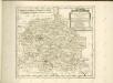
Das Fürstenthum Oppeln in Ober Schlesien
Mollova mapová sbírka Schleuen, Johann David Schleuen, Johann David
Das Fürstenthum Oppeln in Ober Schlesien
1 : 720000 Horní Slezsko Schleuen, Johann David I.D. Schleuen
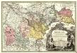
Principatvs Silesiae Oppoloniensis exactissima Tabula geographica, sistens Circvlos Oppoloniensem Ober-Glogav Gros Strehliz, Cosel, Tost, Rosenberg, Falckenberg & Lvblenitz.
1 : 216000 Mollova mapová sbírka Wieland, Johann Wolfgang Homann, Johann Baptista - dědici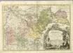

Neisse 91, uit: Special-Karte von Mittel-Europa / nach amtlichen Quellen bearbeitet von W. Liebenow
1 : 300000 titelvariant: W. Liebenow's Mittel-Europa; Annotatie: Titel boven de bladen: W. Liebenow's Mittel-Europa Johannes Wilhelm Liebenow 1822-1897 Frankfurt a. M. : Ludwig Ravenstein
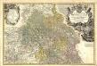
Principatvs Silesiae Bregensis
1 : 145000 Mollova mapová sbírka Wieland, Johann Wolfgang Homann, Johann Baptista - dědici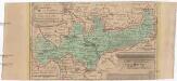
Das Fürstenthum Brieg in Nieder-Schlesien
1 : 460000 Dolní Slezsko Schleuen, Johann David I.D. Schleuen
171 Neisse, uit: Topographische Special-Karte von Deutschland (von Central-Europa) / begründet von D.G. Reymann ; [entworfen und gezeichn. von Heinrich Berghaus... [et al.]]
1 : 200000 Annotatie: Lit.: Daniel Gottlob Reymann und die "Topographische Special-Karte von Deutschland" / von Wolfgang Scharfe, in: Kartographische Nachrichten, 39 (1989), Heft I, p. 1-10; Handgeschreven titel: Reymann's Deutschland : 24 Sectionen: Jena, Penig, Dresden, Zittau, Hirschberg, Breslau, Brieg, Andernach, Coblenz, Giessen, Fulda, Schleusingen, Plauen, Zwickau, Teplitz, Jung Bunzlau, Hohenelbe, Glatz, Neisse, Simmern, Prag, Luxemburg, Birkenfeld; Aanwezig: 23 bladen Reymann, Daniel Gottlob; Berghaus, Heinrich [Berlin : 2. Departement des Kriegsministeriums, Bureau für Plan- und Kartenzeichnung]
Reymann ́s Special Karte 171 Neisse

Geognostische Karte von Ober-Schlesien
1 : 200000 Dolnoslezské vojvodství (Polsko) Carnall, Rudolph von Simmon Schropp & co.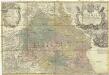
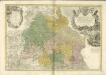
Principatvs Silesiae Oppoliensis
1 : 218000 Opolsko (Polsko) Wieland, Johann Wolfgang Homannianis Heredibus
Die Grafschaft Glaz in zwei Abtheilungen zum Breslauer Regierungs Bezirg gehörig
1 : 190000 Kladsko-oblast (Polsko) Schilling F.E.C. Leuckart
Granica Polski na Śląsku górnym
1 : 600000 Polsko Instytut kartograficzny Atlas