Maps of Kamianets-Podilskyi

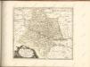
Kamieniec Podolski
1 : 75000 Novakovic K. u. k. Militärgeographisches Institut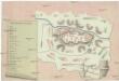
Plan der Vestung Chotzin
Chotyn (Ukrajina) Le Comte, C. Bastius, Petrus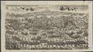
Plan du Camp de Cotzchim
[S.l.] : [s.n.]
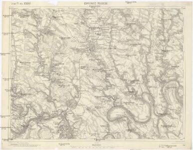
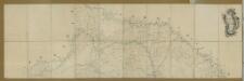
Kamieniec Podolski.
from Spezialkarte der osterreichisch-ungarischen Monarchie.


Mielnica.
from Spezialkarte der osterreichisch-ungarischen Monarchie.
Generalkarte von Zentraleuropa

Generalkarte von Zentraleuropa

Czernowitz
1 : 400000 Instytut wojskowo-geograficzny
Neue Generalkarte des Österr.-ungar.-russischen Kriegsschauplatzes

[Bodolien, Moldawien]
1 Karte : Kupferdruck ; 18 x 13 cm [Trattner]
Ukrainae pars, quae Podolia palatinatus vulgo dicitur / per Guil. le Vasseur de Beauplan s. r. m.tis
1 : 420000 1 Karte : Kupferdruck ; 43 x 52 cm Beauplan, Guillaume le Vasseur de [Verlag nicht ermittelbar]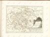
Nr. 6b. Kämpfe in Ostgalizien. Im Dnjestrgebiet
Galizien Weltkrieg <1914-1918>, Ostfront
Tarnopol, Brody, Stryj, Czernowitz
1 : 750000 Brody (Ukrajina) Erben, F. K. u. k. Militärgeographisches Institut
Tarnopol, Brody, Stryj, Czernowitz
1 : 750000 Brody (Ukrajina) Erben, F. K. u. k. Militärgeographisches Institut
Tarnopol, Brody, Stryj, Czernowitz
1 : 750000 K. u. k. militär-geographisches Institut
Tarnopol, Brody, Stryj, Czernowitz
1 : 750000 Brody (Ukrajina) K. k. militär-geographisches Institut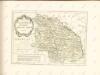

Carte de la Roumanie et pays limitrophes. Lemberg
1 : 500000 France. Service géographique de l'armée [Paris] : Service géographique de l'armée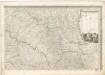
Mappa generalis regni Hungariae partiumque adnexarum Croatiae, Slavoniae...
Carte de la Moldavie
1 : 330000 Moldawien, Bessarabien
Übersichtskarte von Mittel - Europa

V, uit: General-Karte des oesterreichischen Kaiserstaates mit einem grossen Theile der angrenzenden Länder / durch Josef Scheda ... bearb. und hrsg
1 : 576000 Annotatie geografische gegevens: Maatstokken: oesterreichische Meilen, geografische oder deutsche Meilen, preussische Meilen, türkische Berri, französische Lieues, russische Werste; Maatstok per blad: wiener Klafter, öster. Meilen; Blad XIX: statistische en taalkundige informatie; Blad XIX: legenda [Wien : K.K. Militärisch-Geografisches Institut]
G. Freytags Detailkarte von Nord-Rumänien (Moldau) und der Bukowina
1 : 400000 Bukovina (Rumunsko a Ukrajina) G. Freytag & Berndt
Übrige Länder der ehemaligen Österreich-Ung. Monarchie
1 : 900000 Bukovina (Rumunsko a Ukrajina) Koch, Wilhelm Opitz, Carl Arnd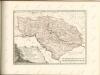
Gouv. 30. Kherson, 33. Bessarabien
1 : 2300000 1 Karte : Lithographie ; 22 x 26 cm Schlieben, W.E.A. von [Georg Joachim Göschen]