Maps of gmina Tuchów

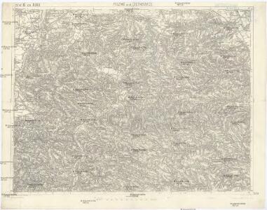
Pilzno und Cieżkowice
1 : 75000 Pilzno-oblast (Polsko) Grob, R. K. u. k. Militärgeographisches Institut
Pilzno und Ciezkowice.
from Spezialkarte der osterreichisch-ungarischen Monarchie.
Reliefkarte Gorlice-Tarnów
Polen Tarnów Weltkrieg <1914-1918> Verl. Gerhard Stalling, Oldenburg
Vom Dunajec bis zum Wislok
1 : 160000 Polen Dunajec-Gebiet Weltkrieg <1914-1918> Verl. Gerhard Stalling, Oldenburg
Die vom 2. bis 7. Mai 1915 abends erreichten Linien
1 : 515000 Polen Tarnów Weltkrieg <1914-1918> Verl. Gerhard Stalling, Oldenburg

Sanok 108, uit: Special-Karte von Mittel-Europa / nach amtlichen Quellen bearbeitet von W. Liebenow
1 : 300000 titelvariant: W. Liebenow's Mittel-Europa; Annotatie: Titel boven de bladen: W. Liebenow's Mittel-Europa Johannes Wilhelm Liebenow 1822-1897 Frankfurt a. M. : Ludwig Ravenstein

Tarnow und Dabrowa.
from Spezialkarte der osterreichisch-ungarischen Monarchie.
Brzostek und Strzyzow.
from Spezialkarte der osterreichisch-ungarischen Monarchie.
Crybow und Corlice.
from Spezialkarte der osterreichisch-ungarischen Monarchie.
Tarnów und Dąbrowa
1 : 75000 Dąbrowa Tarnowska-oblast (Polsko) Ansion K. u. k. Militärgeographisches Institut
Die im Stadtbuch von Zipser Neudorf genannten Orte
Zips, Spišská Nová Ves, Stadtbuch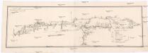
Projectirte Strasse von Billiz bis Lemberg
1 : 560000 Bielsko-Biała (Polsko) Gross
West Galizien
Bochnia (Polsko) Müller, Karl Metzburg, Georg Ignaz von im Verlage des Kunst und Industrie Comptoirs
West Galizien
Halič (Polsko a Ukrajina) Müller, Karl Metzburg, Georg Ignaz von im Verlage des Kunst und Industrie Comptoirs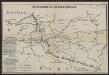
Übersichtskarte des Kampfgeländes
1 : 650000 Polen Tarnów Weltkrieg <1914-1918> Verl. Gerhard Stalling, Oldenburg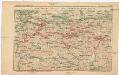
Strecke
Krakov (Polsko) K. k. Österreichische Staatsbahnen
Ost-Galizien
Halič (Polsko a Ukrajina) Liesganig, Joseph im Verlage des Kunst und Industrie Comptoirs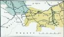
Nr. 13. Der Durchbruch bei Tarnow-Gorlice. (2. Mai 1915.)
Gorlice (Region) Gorlice / Schlacht, Weltkrieg <1914-1918>
Die Donau, der Fürst aller Europaeischen Flüsse :
Mollova mapová sbírka Hoffmann, Johannes Hoffmann, Johann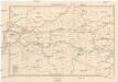
Galizien, Westlicher Theil
1 : 700000 Halič (Polsko a Ukrajina) Karl Fr. Pfau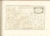

Carte de la Roumanie et pays limitrophes. Cracovie
1 : 500000 France. Service géographique de l'armée [Paris] : Service géographique de l'armée
Krakau, Przemysl, Jaroslau, Kaschau, Leutschau
1 : 750000 Krakov (Polsko : oblast) Geng, K. K. u. k. Militärgeographisches Institut
Krakau, Przemysl, Jaroslau, Kaschau, Leutschau
1 : 750000 Krakov (Polsko : oblast) Geng, K. K. u. k. Militärgeographisches Institut
Krakau, Przemyśl, Jaroslau, Kaschau, Leutschau
1 : 750000 Jarosław (Polsko) R. Lechner
Krakau, Przemyśl, Jaroslau, Kaschau, Leutschau
1 : 750000 Jarosław (Polsko) K. k. militär-geographisches Institut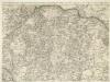
Augustissimo Romanor. Imperatori Iosepho I. Hungaria Regi Invictissimo Mappam Hanc Regni Hungariae
1 : 540000 Mollova mapová sbírka Müller, Johann Christoph