Maps of gmina Mircze

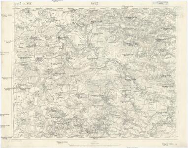
Waręż
1 : 75000 Polsko Charlemont K. u. k. Militärgeographisches Institut
Warez.; Spezialkarte der osterreichisch-ungarischen Monarchie.
from Spezialkarte der osterreichisch-ungarischen Monarchie. Austro-Hungarian Monarchy. Militärgeographisches Institut.,

Speciální mapa západního Ruska

Steniatyn
1 : 75000 Matskassy, F. K. u. k. Militärgeographisches Institut
Steniatyn
1 : 75000 Matskassy, F. K. u. k. Militärgeographisches Institut
Generalkarte von Zentraleuropa

Generalkarte von Zentraleuropa

Ethnographische Uebersicht nach den Bezirksdurchschnitten
Polen Chełm (Województwo) Podlachien Ethnische Gruppe Auner, H.
Ethnographische Uebersicht nach überwiegenden Siedlungsverhältnisse
Polen Chełm (Województwo) Podlachien Ethnische Gruppe Auner, H.
Religion and language maps of Lublin province, Poland no.08
1 : 750000 Religion and language maps of Lublin province, Poland. Religion map by gminas showing relative majorities according to figures of Warsaw Statistical Committee, 1909. Based on information strongly biassed against the Catholics. War Office
Übrige Länder der ehemaligen Österreich-Ung. Monarchie
1 : 900000 Halič (Polsko a Ukrajina) Koch, Wilhelm Opitz, Carl Arnd
Brest-Litowsk, Pinsk, Ostrog, Kołki
1 : 750000 Brest (Bělorusko : oblast) Geng, K. K. u. k. Militärgeographisches Institut
Sheet V: Karte Des Oesterreichischen Kaiserstaates.
1 : 576000 Scheda, Josef
V, uit: General-Karte des oesterreichischen Kaiserstaates mit einem grossen Theile der angrenzenden Länder / durch Josef Scheda ... bearb. und hrsg
1 : 576000 Annotatie geografische gegevens: Maatstokken: oesterreichische Meilen, geografische oder deutsche Meilen, preussische Meilen, türkische Berri, französische Lieues, russische Werste; Maatstok per blad: wiener Klafter, öster. Meilen; Blad XIX: statistische en taalkundige informatie; Blad XIX: legenda [Wien : K.K. Militärisch-Geografisches Institut]
Übersichtskarte von Mittel - Europa

Pohlen, Rußland, Gallicien, Wolhinien, Podolien. Ungarn. Ungvárer Comitat
Ungarn Verkehrsweg
Strassen- und Eisenbahnkarte des oesterreichischen Kaiserthumes
1 : 864000 Blatt 4 Schaller, G. K.K. Militärisch-Geografisches Institut, Karten-Evidenthaltungs-Abteilung
Übersichtskarte von Mittel - Europa
Strassen und Eisenbahnkarte des oesterreichischen Kaiserthumes

Strategische Übersichts-Karte des polnisch-litaurischen Armee-Bewegungraumes

Národnostní mapa Republiky československé
Boháč, Antonín
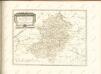
Lubomeriae et Galliciae Regni Tabula Geographica
1 : 1100000 Mollova mapová sbírka Homann, Johann Baptist Homann, Johann Baptista - dědici
Blatt IV, uit: Geologische Übersichts-Karte der Österreichisch-Ungarischen Monarchie / nach den Aufnahmen der K.K. Geologischen Reichsanstalt bearb. von Franz Ritter von Hauer ; gezeichn. von Eduard Jahn
1 : 576000 Annotatie geografische gegevens: Gebaseerd op veldwerk in de jaren 1850 tot 1865 Hauer, Franz Ritter von; Jahn, Eduard; Kaiserlich-Königliche Geologische Reichsanstalt, Wenen Wien : Beck
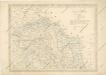
Russie noire / tirée pour la plus grande partie de la grande carte de l'Ukraine, du Sr. le Vasseur
1 : 870000 1 Karte : Kupferdruck ; 44 x 50 cm Sanson, Nicolas chez P. Marinette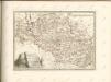

Nástěnná mapa Československé republiky
Machát, František