Maps of Kostopil
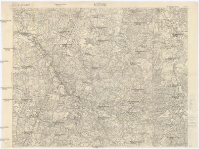
Kostopol
1 : 75000 K. u. k. Militärgeographisches Institut
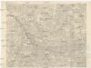
Tuczyn
1 : 75000 K. u. k. Militärgeographisches Institut
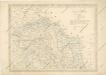
Neue Generalkarte des Österr.-ungar.-russischen Kriegsschauplatzes

Brest-Litowsk, Pinsk, Ostrog, Kołki
1 : 750000 Brest (Bělorusko : oblast) Geng, K. K. u. k. Militärgeographisches Institut
Bez titulu: Šest listů speciálních map Ukrajiny

Übersichtskarte von Mittel - Europa

Strassen- und Eisenbahnkarte des oesterreichischen Kaiserthumes
1 : 864000 Blatt 4 Schaller, G. K.K. Militärisch-Geografisches Institut, Karten-Evidenthaltungs-Abteilung
Übersichtskarte von Mittel - Europa
Strassen und Eisenbahnkarte des oesterreichischen Kaiserthumes

Sheet V: Karte Des Oesterreichischen Kaiserstaates.
1 : 576000 Scheda, Josef
Nova et accurata Turcicarum et Tartaricarum Provinciarum / excudit à Matth. Seuttero, S.C.M. Geogr
1 : 5400000 1 Karte : Kupferdruck ; 18 x 24 cm Lotter, Tobias Conrad anjezo im Verlag bey T.C. Lotter
Gouv. 30. Kherson, 33. Bessarabien
1 : 2300000 1 Karte : Lithographie ; 22 x 26 cm Schlieben, W.E.A. von [Georg Joachim Göschen]
Blatt IV, uit: Geologische Übersichts-Karte der Österreichisch-Ungarischen Monarchie / nach den Aufnahmen der K.K. Geologischen Reichsanstalt bearb. von Franz Ritter von Hauer ; gezeichn. von Eduard Jahn
1 : 576000 Annotatie geografische gegevens: Gebaseerd op veldwerk in de jaren 1850 tot 1865 Hauer, Franz Ritter von; Jahn, Eduard; Kaiserlich-Königliche Geologische Reichsanstalt, Wenen Wien : Beck
The dominions of Moscovy or Russia / by H. Moll Geographer
1 : 38000000 1 Karte : Kupferdruck ; 17 x 24 cm Moll, Hermann [Verlag nicht ermittelbar]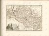

Théatre de la guerre actuelle, en Allemagne, en Pologne et en Turquie. n5, Brody
1 : 900000 Chanlaire, Pierre Grégoire 1758-1817 Paris : chez l'auteur P. G. Chanlaire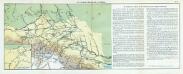
Nr. 5. Der deutsche Durchbruch in Galizien
Galizien Weltkrieg <1914-1918>, Ostfront
Gipsometričeskaja karta Polěs'ja s oboznačenijem kanalizacii
1 : 1250000 Polesí
Geologičeskaja karta Polěs'ja
1 : 1250000 Polesí
The dominions of Moscovy in Europe / By Herman Moll Geographer
1 : 14000000 1 Karte : Kupferdruck ; 17 x 24 cm Moll, Hermann [Verlag nicht ermittelbar]
Galizien, Karpathen, Bukowina nebst anschließendem Ungarn, Russland u. s. w.
Ravenstein, Hans
Lubomeriae et Galliciae regni tabula geographica
1 : 1088000 Halič (Polsko a Ukrajina) Güssefeld, Franz L. impensis Homannianorum Haeredum
Einteilung der Grenzwache an der österr. Grenze
Russland Österreich-Ungarn Grenze Militär
L' Ingria e la Carelia Russia / Ab. Borghi disegno ; Pasquali scrisse
1 : 1300000 1 Karte : Kupferdruck ; 30 x 23 cm Borghi, Bartolomeo Presso Pazzini Carli
Kartenskizze des polnisch-weißrussischen Grenzgebietes
Polen Weißrussland Grenzgebiet
Carte nouvelle de l'empire de la Russie, comprise en Europe / dirigée par Mr. Philippe, censeur roy
1 : 7900000 1 Karte : Kupferdruck ; 37 x 24 cm Philippe de Prétot, Etienne André [Nyon]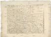
[Západní Ukrajina]
Ukrajina západní Benedicti, Hieronymus
Gouv. 39. Minsk
1 : 2300000 1 Karte : Lithographie ; 26 x 19 cm Schlieben, W.E.A. von [Georg Joachim Göschen]
L' empire de Russie, comprenant la Moscovie, le royaume de Casan etc. / [Le Rouge, Georges Louis]
1 : 11000000 1 Karte : Kupferdruck ; 21 x 27 cm Le Rouge, Georges-Louis [Verlag nicht ermittelbar]