Maps of Northern European Plain

Das europäische Russland
1 : 6588000 Rusko Gräf, Carl Geographisches Institut
Das europaeische Russland
1 : 6500000 entworfen von C.F. Weiland C.J. Maedel sen. sc. Weimar : im Verlage des Geographischen Instituts
Europaeisches Russland mit Kasan, Astrachan und Georgien
Schul-Atlas über alle Theile der Erde nach dem neuesten Zustande, und über das Weltgebäude Stieler, Adolf bei Justus Perthes
La Russie d'Europe
Russland Bielaerts, J. B.
Russia.
1 : 7760000 Johnson, A.J.
Russia.
1 : 7760000 Johnson, A.J.
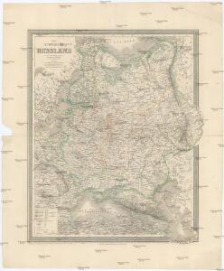
Europäisches Russland
1 : 20500000 Russland / Europäischer Teil
Europäisches Russland

Russland
Russland / Europäischer Teil Skizzenbuch
Europaeisches Russland mit Kasan, Astrachan und Georgien
Russland / Europäischer Teil
Visečí mapa Europy
mapa VKOL Kocen, Blaž Skladem Eduarda Hölzela
Russland
1 : 15000000 Russland / Europäischer Teil
TABVLA | RVSSIÆ | ex autographo, quod delineandum | curavit Foedor filius Tzaris Boris desum- | ta; et ad fluvios Dwinam, Zuchanam, aliaque | loca, quantum ex tabulis ex notitiis ad nos dela- | tis fieri potuit, amplificata...
Amstelodami, | Excusum Apud Guiljelmum Blaeu
Karte der Vergrösserungen Russlands unter Peter dem Grossen und seinen Nachfolgern
Russland Peter I.
Ravensteinkarte Osteuropa
1 : 3333333 Evropa střední a východní Ravensteins Geographische-Verlagsanstalt und Druckerei
Russland
1 : 15000000 Evropa východní Kocen, Blaž Eduard Hölzel
Des Russischen Reichs Europäischer Theil
Stieler's Hand-Atlas Stieler, Adolf bei Justus Perthes
Russland
Russland / Europäischer Teil
Karte der Vergrösserungen Russlands unter Peter dem Grossen und seinen Nachfolgern
Russland Peter I.
Ruszland
1 : 18000000 Russland / Europäischer Teil
Europäisches Russland
1 : 14500000 Russland / Europäischer Teil
Russisches Reich. Verwaltungsgrenzen von 1914. Europäischer Teil
Russland / Europäischer Teil Verwaltungsgliederung
Europäisches Russland
Russland / Europäischer Teil Skizzenbuch
Karta evropejskoj Rossii i Sibiri
1 : 5000000 Azovské moře-oblast (Ukrajina a Rusko) Ševelev, A.
Europäisches Russland
1 : 5000000 Rusko západní Handtke, Friedrich Carl Flemming, Verlag, Buch- und Kunstdruckerei
Carte de la Pologne à son apogee, sous Sigismond-Auguste, en face du Principat de Russie sous le czar Ivan IV, vers l’an 1570 de notre ère
Polen Russland Polen-Litauen Zygmunt August
Russia Europea: Carta politica-administrativa della Russia dei Sovieti nell 1923
1 : 5000000 Istituto Geografico de Agostini di C. Rossi e A.M. Boroli Visintin, L.
Europäisches Russland
1 : 14500000 Russland / Europäischer Teil
Tabvla Rvssiæ / ex autographo, quod delineandum curavit Foedor filius tzaris Boris desumta; et ad f
1 : 9000000 1 Karte : Kupferdruck ; 41 x 53 cm Fëdor excusum apud Guiljelmum Blaeu