Maps of Chernihiv

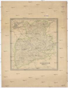
Karta Černigovskoj gubernii
1 : 840000 Černigov-oblast (Ukrajina) Kartogr. zav. A. Il'jina
Speciální mapa západního Ruska
Österreich-Ungarns letzter Krieg
1 : 750000 Dunaj-delta (Rumunsko a Ukrajina) Verlag der Militärwissenschaftlichen Mitteilungen
Kiew & Höhlenkloster
1 : 200000 Kiew, Pecers'ka Lavra (Kiew)
Boj pri d. Lěsnoj 28 sentjabrja 1708 g.
Weißrussland Lesnaya Nordischer Krieg <1700-1721>
Kiew
1 : 50000 Kiew
Partie, Russie d'Europe. Europe 15.
1 : 1641836 Vandermaelen, Philippe, 1795-1869
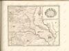
Li Palatinati di Braclaw

Internationale Weltkarte. M - 36 Kijev

Europe 1:1,000,000, Kiev
Sheet including Ukraine from the map series: Europe. Scale, 1 :1,000,000. [Including Asia Minor, Mesopotamia, etc.] Provisional edition. Compiled at the Royal Geographical Society ... drawn and printed by the Ordnance Survey G.S.G.S. No. 2758. London : Geographical Section, General Staff.
Strategische Übersichts-Karte des polnisch-litaurischen Armee-Bewegungraumes
Basse Volhynie, ou palatinat de Kiow / tiré entierement de la gra[n]de Ukraine, du Sieur le Vasseur
1 : 875000 1 Karte : Kupferdruck ; 41 x 56 cm Sanson, Nicolas chez P. Mariette
Kijew, Žitomir, Owrucz, Czernobyl, Mozyr, Łojew
1 : 750000 Kyjev (Ukrajina : oblast) Korb, L. K. u. k. Militärgeographisches Institut
Bobrujsk, Czerikow, Str. Szkłow
1 : 750000 Bobrujsk (Bělorusko) Dornhofer, J. K. u. k. Militärgeographisches Institut
Bobrujsk, Czerikow, Str. Szkłow
1 : 750000 Bobrujsk (Bělorusko) K. k. militär-geographisches Institut
Kijew, Žitomir, Owrucz, Czernobyl, Mozyr, Łoiew
1 : 750000 Kyjev (Ukrajina : oblast) K. k. militär-geographisches Institut
Übersichtskarte von Mittel - Europa

Théatre de la guerre actuelle, en Allemagne, en Pologne et en Turquie. n5, Brody
1 : 900000 Chanlaire, Pierre Grégoire 1758-1817 Paris : chez l'auteur P. G. Chanlaire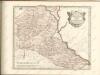

Übersichtskarte von Mittel - Europa

Li palatinati di Braclaw, e Kiowia / tratta dall'atlante polacco del Sig.r Rizzi Zanoni ; G. Zuliani
1 : 740000 1 Karte : Kupferdruck ; 40 x 31 cm Zuliani, Giuliano presso Antonio Zatta
Umgegend von Kiew
Kiew, Umland
Operacīja Petra Velikago protiv Levengaupta.
Europa
TRACTVS | BORYSTHENIS | Vulgo DNIEPR et NIEPR dicti, | à KIOVIA usque ad BOUZIN.
Amstelædami | Excud. I. BLAEV.
[Recto], uit: Archangel Port : revised plan of saw mills and loading places
1 : 90000 Annotatie geografische gegevens: Met legenda, 1-45 Archangel : A.J. Anderson & Son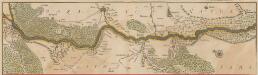
Tractus Borysthenis Vulgo Dniepr et Niepr dicti, à Kiovia ad Urbum Oczakow ubi in pontum Euxinum se exonerat. [Karte, Teil 1], in: Novus atlas absolutissimus, Bd. 1, S. 73.
1 Karte aus Atlas Janssonius Offizin
Dviženīe 1j i 2j armīi k Smolensku.
Russland Smolensk Russlandfeldzug <1812>
Lithvania
1 Karte : Kupferdruck ; 36 x 42 cm Mercator s.n.