Maps of Erongo Region

Carte internationale du monde au 1,000,000 E
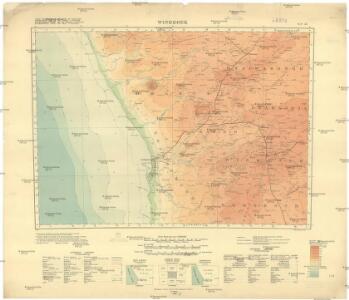
1 : 1000000 Windhoek (Namibie) Surveyor generals office S.W. Africa
General overview of the farms in parts of the Windhoek and Karibib districts

Sheet Windhoek

Cote Deserte. Afrique 48.
1 : 1641836 Vandermaelen, Philippe, 1795-1869
No title

Deutsche Kolonien
1 : 12000000 Kamerun Meyer, Joseph Bibliographisches Institut
Gross-Namaqua-Land und das Gebiet des Hauses F.A. Lüderitz
1 : 1750000 Durynsko (Německo) Hassenstein, Bruno Hahn, Th. Justus Perthes
Deutsch-Südwestafrika
1 : 2000000 Namibie Sprigade, Paul Fischer, R. Dietrich Reimer (Ernst Vohsen)
Deutsch-Südwest-Afrika
1 : 3000000 Kiepert, Richard ; Sprigade, Paul Geographische Verlagshandlung Dietrich Reimer
South Africa.
1 : 4118400 Fullarton, A. & Co.
Union of South Africa Special Map Accompanying Richmond's South African All Mining Year Book (Sheet 1)
Union of South Africa. Special map accompanying Richmond's South African All Mining Year Book illustrating the location of Mines, Quarries and Works. Johannesburg : Hortors
St. Helena, this island belongs to ye English east India Company whose ships usually touch here for a recruit of fresh water and provisions ... ; The bay of Agao de Saldanha, this bay is 70 miles north of ye Cape of Good Hope ...
1 : 1
Spezial-Karte von Afrika
1 : 4000000 Blatt 9 Habenicht, Hermann Perthes
Karte des Afrikander-Aufstandes im Kaplande und des Angriffskrieges der Buren
1 : 4000000 Langhans, Paul Perthes
[LL.04716gk: 591/od/1899], uit: Kaart van Zuid-Afrika : (Zuid-Afrikaansche Republiek, Oranje-Vrijstaat en aangrenzend gebied)
1 : 5600000 Amsterdam [etc.] : J.H. de Bussy
[LL.04752gk: 591/od/1899] [Recto], uit: Kaart van Zuid-Afrika : (Zuid-Afrikaansche Republiek, Oranje-Vrijstaat en aangrenzend gebied)
1 : 5600000 Amsterdam [etc.] : J.H. de Bussy
Karte von Transvaal und der angrenzenden Gebiete
1 : 5000000 Afrika jižní Dietrich Reimer (Ernst Vohsen)
Politisch-militärische Karte von Süd-Afrika : zur Veranschaulichung der Kämpfe zwischen Buren und Engländern bis zur Gegenwart / Paul Langhans
1 : 4000000 Langhans, Paul Gotha : Justus Perthes
South Africa.
1 : 5000000 John Bartholomew and Son
Charte von Nieder Guinea
Angola
CHARTE von NIEDER GUINEA
Angola
Nieder Guinea, W. Mittel-Africa.
1 : 5500000 Weiland, C. F. (Carl Ferdinand), d. 1847
Politisch - militärische Karte von Süd-Afrika

[LL.04751gk: 591/od/1899] [Recto], uit: Kaart van Zuid-Afrika : (Zuid-Afrikaansche Republiek, Oranje-Vrijstaat en aangrenzend gebied)
1 : 5600000 Amsterdam [etc.] : J.H. de Bussy
Spezial - karte von AfricaSektion Capland (9)
1 : 4000000 1 full d'1 mapa en 10 fulls i estoig Hermann Habenicht; Justus Perthes
Itinéraire de Mr et Mme Coillard du Pays des Bassoutos au Zambèze
1 : 12100000 [Paris] : Société de géographie
[Kaart], uit: Karte des Afrikander-Aufstandes im Kaplande und des Angriffskrieges der Buren / Paul Langhans
1 : 4000000 titelvariant: Karte des Afrikander-Aufstandes im Kaplande; Annotatie: Omslagtitel: Karte des Afrikander-Aufstandes im Kaplande; Met portret van Christian de Wet Langhans, Paul Gotha : Perthes
La Basse Guinée, contenant les royaumes de Loango, de Congo, d'Angola et de Benguela, avec la Cafrérie occidentale et la méridionale, ou le pays des Hotentots
1 : 9600000 Angola Bonne, Rigobert André
Nieder-Guinea und das Innere des Westlichen Mittel-Africa's oder Westrand von Hoch-Africa
1 : 5480000 entworfen und gezeichnet von C.F. Weiland gestochen von Karl Mädel sen. Weimar : Geographisches Institut