Maps of Rupt-sur-Moselle
Montagnes françaises
1 : 80000 Francie
Meßtischblatt 3675 : Urbis, 1887
1 : 250000 Urbis. - Aufn. 1885. - 1:25000. - [Berlin]: Reichsamt für Landesaufnahme, 1887. - 1 Kt.
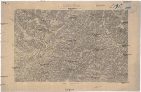
Meßtischblatt 3667 : Wildenstein, 1885
1 : 250000 Wildenstein. - Aufn. 1884. - 1:25000. - [Berlin]: Reichsamt für Landesaufnahme, 1885. - 1 Kt.
144 Luxeuil.
1 : 86400 Cassini family; Cassini, Cesar-Francois, 1714-1784
184. Gebweiler, uit: Topographische Uebersichtskarte des Deutschen Reiches / herausgegeben v. d. Kartogr. Abt. d. Königl. Preuß. Landesaufnahme
1 : 200000 titelvariant: Topogr. Übersichtskarte des Deutschen Reiches; Annotatie: Titel boven bladen ook: Topogr. Übersichtskarte des Deutschen Reiches; Annotatie geografische gegevens: Op elk blad twee maatstokken: 10 Kilometer = 5,5 cm; 1 geogr. Meile = 3,6 cm; Legenda onder op elk blad Königlich Preußische Landesaufnahme. Kartographische Abtheilung [S.l : Königlich Preußische Landesaufnahme, Kartographische Abtheilung]
Colmar 140, uit: [W. Liebenow's Special-Karte von Mittel-Europa]
1 : 300000 titelvariant: W. Liebenow's Mittel-Europa; Annotatie: Titel boven de bladen: W. Liebenow's Mittel-Europa Johannes Wilhelm Liebenow 1822-1897 Hannover : Hermann Oppermann
Colmar 140, uit: Special-Karte von Mittel-Europa / nach amtlichen Quellen bearbeitet von W. Liebenow
1 : 300000 titelvariant: W. Liebenow's Mittel-Europa; Annotatie: Titel boven de bladen: W. Liebenow's Mittel-Europa Johannes Wilhelm Liebenow 1822-1897 Frankfurt a. M. : Ludwig Ravenstein
Département du Haut Rhin
1 Karte : Kupferdruck ; 35 x 39 cm Capitaine s.n.
Carte topographique d'Allemagne
1 : 224000 Alsasko (Francie) Jaeger, Johann Wilhelm Abraham I.W.A. Iaeger
Carte topographique d'Allemagne
1 : 224000 Alsasko (Francie) Jaeger, Johann Wilhelm Abraham I. W. A. Iaeger
Le Theatre de Bellone :
Mollova mapová sbírka Schenk, Pieter Braakman, Adriaan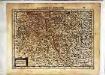
Lorraine vers le midy
1 Karte : Kupferdruck ; 17 x 23 cm Mercator Cloppenburgh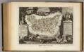
Dept. Des Vosges.
1 : 585000 Levasseur, Victor.
Département du Haut Rhin
1 Karte : Kupferdruck ; 48 x 48 cm Houdan au bureau de l'atlas national rue de la Harpe no. 26, et au depôt de cet atlas rue de la Monnoye no. 5
Basiliensis Territorii Descriptio Nova
1 : 310000 Mollova mapová sbírka Münster, Sebastian Plantin, Christoph
Lorraine vers le midy
1 Karte : Kupferdruck ; 36 x 48 cm Janssonius Joannes Janssonius
[Luxeuil]
1 Blatt : 61 x 91 cm s.n.
Sequani Partie des Archidconnes de Favernay et de Luxeuil du Dioecese de Besancon
1 : 240000 Mollova mapová sbírka Sanson, Nicolas Somer, Jean Pruthenus Sanson, Nicolas
Les Prevotez Offices Senéchaussée, et Comté, qui font Partie de Balliages de Vosge ou Mirecour et de Nancy, dans le Duché Lorraine les Terres Adjacentes d'Épinal, de Chaté &c. :
1 : 180000 Mollova mapová sbírka Jaillot, Alexis-Hubert Jaillot, Alexis Hubert
Département des Vosges
1 : 265000 Vosges (Francie) Houdan, François d' P. G. Chanlaire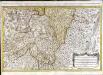
Les prevotez, offices, senéchaussée et comté, qui font partie des balliages de Vosge ou Mirecour et de Nancy
1 Karte : Kupferdruck ; 43 x 68 cm Jaillot Alexis-Hubert Jaillot
Territory Basiliensis Nova Descriptio
1 : 21000 Mollova mapová sbírka Janssonius, Johannes Janssonius, Johannes I
Le Theatre de la Guerre Sur le Haut Rhein
1 : 142000 Mollova mapová sbírka Sanson, Guillaume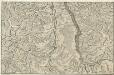
Le Cours du Rhein, depuis Spire jusqu'a Mayence
1 : 180000 Mollova mapová sbírka Fer, Nicolas de Starckman, P. Fer, Nicolas de
Le cours du Rhin de Bâle à Hert près Philisbourg contenant l'Alsace et partie du Brisgau, 1
1 Blatt : 76 x 52 cm Le Rouge
Belfort, Basel
1 : 100000 1 Karte par Aug. Jaccard et Alb. Muller [i.e. Müller] [Wurster & Randegger], [Winterthur]
Topographische Karte der Schweiz
1 : 100000 25 Karten vermessen und hrsg. auf Befehl der Eidgenössischen Behörden ; aufgenommen unter der Aufsicht des Generals G.H. Dufour Eidg. Topographisches Bureau, [Genève], [später: Bern]
Le cours du Rhin de Bâle à Hert près Philisbourg contenant l'Alsace et partie du Brisgau, 2
1 Blatt : 75 x 52 cm Le Rouge
Belfort