Maps of Rabat-Salé-Kenitra

Carte touristique du Maroc
1 : 500000 Fez (Maroko) Service géographique
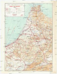
Carte générale du Maroc à l'échelle de 1 : 500 000 e. Tanger
1 : 500000 Maroc. Service géographique Rabat : Service géographique du Maroc
Maroc (500 000 e). Fez
1 : 500000 France. Service géographique de l'armée Service géographique de l'Armée
Carte générale du Maroc à l'échelle de 1 : 500 000 e. Rabat
1 : 500000 Maroc. Service géographique Rabat : Service géographique du Maroc
Fès. Vallée du Sebou
1 : 250000 Larras, Nestor Prosper 18..-19..; France. Service géographique de l'armée Paris : H. Barrère
Tanger
1 : 250000 Larras, Nestor Prosper 18..-19..; France. Service géographique de l'armée Paris : H. Barrère
Mapa del norte de Marruecos
1 : 100000 1 full d'1 mapa en 12 fulls entelats de 2 en 2 fulls dins d'un estoig. Datat entre 1920 i 1930. [Cuerpo de Estado Mayor del Ejército?]
Mapa del norte de Marruecos
1 : 100000 1 full d'1 mapa en 12 fulls entelats de 2 en 2 fulls dins d'un estoig. Datat entre 1920 i 1930. [Cuerpo de Estado Mayor del Ejército?]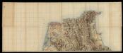
Mapa del norte de Marruecos
1 : 100000 1 full d'1 mapa en 12 fulls entelats de 2 en 2 fulls dins d'un estoig. Datat entre 1920 i 1930. [Cuerpo de Estado Mayor del Ejército?]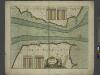
A chart of the STRAITS of GIBRALTER
from The sea-atlas : containing an hydrographical description of most of the sea-coasts of the known parts of the world.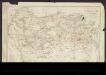
Carte provisoire de la région de Fez
1 : 100000 Weisgerber, Frédéric 1868-1946 Paris : H. Barrère
De baai van Tanger
Morocco Gerard van Keulen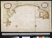
Baije de Tanger aux cotes de Barbarie et l'etat ou êtoit le port en l'année 1680 en la posession des Anglois
Morocco Gerard van Keulen
Porto Tanger
Morocco Gerard van Keulen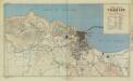
Morocco town plans (1942/43), Tangier
Morocco town plans , Series GSGS 4241. Great Britain. War Office. [London] : War Office.
Tanger (1907) (Sheet 1)
Tanger / Levantamiento ejecutado por la Comisión del Cuerpo de E.M. del Ejército en Marruecos, 1907. [S.l.] : Depósito de la Guerra
Plan de Taza
1 : 10000 Maroc. Service géographique [Rabat] : Service géographique du Maroc
Tanger (1907) (Sheet 2)
Tanger / Levantamiento ejecutado por la Comisión del Cuerpo de E.M. del Ejército en Marruecos, 1907. [S.l.] : Depósito de la Guerra
Plan of the city of Morocco
Rabat (Maroko) Zeithammer, Antonín Otakar Badía y Leblich, Domingo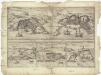
Tingis, Lvsitanis, Tangiara
Tanger (Maroko) Braun, Georg Hogenberg, Franz
The mosque of Tanger
Tanger (Maroko) Zeithammer, Antonín Otakar Badía y Leblich, Domingo
Reiseweg im Marokkanischen Atlas-Vorland im Frühjahr 1899
1 : 2000000 Atlas (pohoří) Fischer, Theobald Gesellschaft für Erdkunde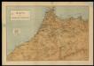
Mapa del imperio de Marruecos
1 Mapa. Datació aproximada. Lit. Mateu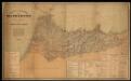
Mapa de la parte norte de Marruecos / por la Comisión de Cuerpo de E.M. del Ejercito ; Talleres del Depósito de la Guerra
1 Mapa. Datació aproximada. Estado Mayor del Ejército (Espanya)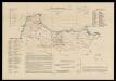
Mapa sociológico de la zona de inflencia española en el norte de Marruecos / por D. Antonio Martinez Pajares, Doctor en Derecho
1 : 500000 1 Mapa, col. Dedicatòria ms. de l'autor, datada el 1916. Datació aproximada. Martínez Pajares, Antonio Lit. J. Mendez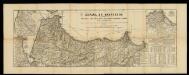
España en Marruecos: mapa de la zona, en el norte del Imperio, asignada a España según el Tratado de 1912 / formado por los señores Elola y Méndez, teniendo presentes los trabajos nacionales y extrageros, dignos de confianza, publicados hasta la fecha
1 : 450000 1 Mapa en fulls, b/n & 2 fulls. Franja de solapament descomptada a les mides. - Conté 4 finestres a escala 1:225 000: Larache y Alcazar; Terreno entre Ceuta y Tetuan; Chafarinas y Cabo de Agua; Cercanias de Melilla y posiciones avanzadas. Datació aproximada. Méndez, J. Lit. J. Mendez
Carte nouvelle De L'ISLE de CADIX & du Detroit de GIBRALTAR
1 : 500000 Cádiz (Španělsko) Petit, Jean de Schneider, Ruprecht A. Weidler
Carte nouvelle de l'Isle de Cadix & du Detroit de Gibraltar
1 : 390000 Cádiz (Španělsko) Petit, Jean de aux depens des Heritiers du feu m. le docteur Homann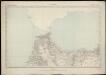
Maroc (500 000 e). Tanger
1 : 500000 France. Service géographique de l'armée Service géographique de l'Armée