Maps of Zagros Mountains

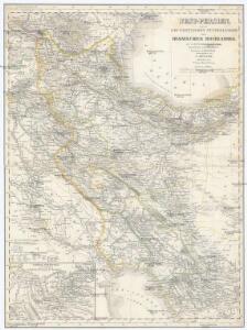
West-Persien, oder die westlichen Stufenländer des Iranischen Hochlandes
1 : 3000000 Šíráz (Írán) Kiepert, Heinrich D. Reimer
Western Persia.
1 : 3380000 Sharpe, J.
145. Iran, North-west and North. Tehran. The World Atlas.
1 : 2500000 USSR (Union of Soviet Socialist Republics).
Partie, la Perse. Asie 65.
1 : 1641836 Vandermaelen, Philippe, 1795-1869
[Westküste des Kaspischen Meeres]
Kaspické moře (oblast)
Prof. C. Haussknecht's Routen im Orient 1865-1869 : III. Kurdistan und Irak
1 : 800000 Kiepert, Heinrich, 1818-1899 Verlag von Dietrich Reimer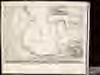
[Carte marine de la mer Caspiene / levée suivant les ordres de S. M. czariene, par Mr. Carl Vanverd
1 : 1600000 1 Kartenblatt : Kupferdruck ; 43 x 59 cm Verden, Carl van [par Reinier Ottens]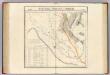
Partie, la Perse, la Turquie. Asie 64.
1 : 1641836 Vandermaelen, Philippe, 1795-1869
Carte internationale du monde au 1,000,000 E
1 : 1000000 Tabríz (Írán) War Office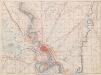
Baghdad
1 : 63360 First World War map of Baghdad. Sheet T.C. 86c War Office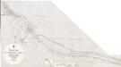
Persian Gulf. Shatt al Arab. Sheet v. Tuwaila I. to Coal I. Natural scale 1 : 25,000
One map on sheet: [Persian Gulf. Shatt al Arab. Sheet v. Tuwaila I. to Coal I. (Basra and Ma'qil. From surveys ... to 1924. Natural scale 1 : 12,500)] London: Admiralty, [1958]
Persian Gulf. Shatt al Arab. Sheet v. Tuwaila I. to Coal I. Natural scale 1 : 25,000
One map on sheet: [Persian Gulf. Shatt al Arab. Sheet v. Tuwaila I. to Coal I. (Basra and Ma'qil. From surveys ... to 1924. Natural scale 1 : 12,500)] London: Admiralty, [1939]
Persian Gulf. Abu Shahr, Bushire
[Persian Gulf. Abu Shahr,--Bushire. Surveyed ... 1904. Natural scale 1 : 23,400]
Umgebung von Baghdâd
1 : 25000 Bagdád (Irák) Andrae Kartogr. Abtlg. d. Kgl. Preuß. Landesaufnahme
Abadan (1926)
Abadan. From a survey by the Port Directorate, Basra, 1924. London : Admiralty
Persian Gulf. Shatt al Arab. Sheet v. Ashar and Ma’qil. (1958)
One map on sheet: [Persian Gulf. Shatt al Arab. Sheet v. Tuwaila I. to Coal I. (Basra and Ma'qil. From surveys ... to 1924. Natural scale 1 : 12,500)] London: Admiralty, [1958]
Persian Gulf. Shatt al Arab. Sheet v. Ashar and Ma’qil.(1939)
One map on sheet: [Persian Gulf. Shatt al Arab. Sheet v. Tuwaila I. to Coal I. (Basra and Ma'qil. From surveys ... to 1924. Natural scale 1 : 12,500)] London: Admiralty, [1939]
Basra-shuʿaiba 1:10,000, 1940 (Sheet 3)
Basra-shuʿaiba 1:10,000. Compiled from air photographs taken on 24 and 25 Oct., 1939 by the R.A.F. Survey of India. Risalpur : Survey of India Offices
Basra-shuʿaiba 1:10,000, 1940 (Sheet 4)
Basra-shuʿaiba 1:10,000. Compiled from air photographs taken on 24 and 25 Oct., 1939 by the R.A.F. Survey of India. Risalpur : Survey of India Offices
Basra-shuʿaiba 1:10,000, 1940 (Sheet 9)
Basra-shuʿaiba 1:10,000. Compiled from air photographs taken on 24 and 25 Oct., 1939 by the R.A.F. Survey of India. Risalpur : Survey of India Offices
Plan von Baghdâd
1 : 10000 Bagdád (Irák) Stellvertretender Generalstab der Armee
Basra-shuʿaiba 1:10,000, 1940 (Sheet 10)
Basra-shuʿaiba 1:10,000. Compiled from air photographs taken on 24 and 25 Oct., 1939 by the R.A.F. Survey of India. Risalpur : Survey of India Offices
Plans of towns in Kuwait. GSGS 4879, (1956) Ahmadi Mina-al
[Plans of towns in Kuwait.] GSGS 4879. [London] : D. Survey, War Office and Air Ministry
Plans of towns in Kuwait. GSGS 4879, (1958) Ahmadi Mina-al
[Plans of towns in Kuwait.] GSGS 4879. [London] : D. Survey, War Office and Air Ministry
Karte von Mesopotamien
1 : 400000 Bagdád (Irák) Kgl. Preuss. Landesaufnahme
Iraq-Iran 1:100,000, K601, Kelek
Iraq-Iran 1:100,000, K601. United States. Army Map Service. Washington, D.C. : Army Map Service
Kaerte van de waerschijnlijkste plaets van den Hof van Eden, de vlakte van Sinear, en den berg, waer op d'Ark gerust heeft, volgens deeze histori
Annotatie: Afkomstig uit dl. I van: Algemeene histori van het begin der wereld af tot den tegenwoordigen tijd toe / ... door Kornelis Westerbaen Wz. - Utrecht : Hermanus Besseling, 1735-1755; Rechtsboven: I Deel tusschen bl. 460 en 461 [Utrecht : H. Besseling excudit]
Persien.
1 : 4430000 Grassl, J. (Joseph)
Assyrie, Babylonie a Persie