Maps of Uttar Pradesh

Southern Asia series
1 : 2000000 Asie jižní Survey of India offices
India 9.
1 : 2217600 Letts, Son & Co.
India IX.
1 : 2200000 Society for the Diffusion of Useful Knowledge (Great Britain)
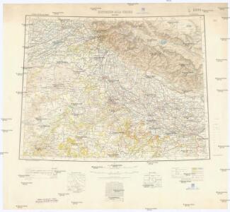
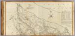
North-Western Provinces, Oudh, and Nepal.
1 : 3990000 W. & A.K. Johnston Limited
Pays d'Ajemeer, d'Agra. Asie 82.
1 : 1641836 Vandermaelen, Philippe, 1795-1869
139. Upper Ganga (Ganges) Valley. Delhi. The World Atlas.
1 : 2500000 USSR (Union of Soviet Socialist Republics).
Die Missionsgebiete der Nordwest-Provinzen
(Delhi, Agrah, Oude, Ellahabad north)
1 : 750000 Dury, Andrew; Kitchin, Thomas; Rennell, James, 1742-1830; Robert Laurie & James Whittle
Arvali region central & eastern
Aravalli Range (Indie) Geological Survey of India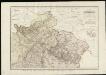
Spezial-Karte vom Himalaya in Kumaon, Gurhwal, Simur &c. &c.
1 : 600000 entworfen nach den astronomischen-trigonometrischen Vermessungen von W. S. Webb, J. A. Hodgson & J. D. Herbert [...] von H. Berghaus gest. von C. F. Wolff Gotha : Perthes
Uebersicht des gegenwärtigen Kriegsschauplatzes in Indien
1 : 1200000 [S.l.] : [s.n.]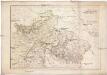
Spezial-Karte vom HIMALAYA in KUMAON, GURHWAL, SIRMUR &C. &C
1 : 600000 Himálaj (pohoří) Berghaus, Heinrich Karl Wilhelm Herbert, J. D. Justus Perthes
Manasarowar
1 : 2500000 United States. Army Map Service. Army Map Service
[Suharunpoor]
Indie Surveyor general's office
Punjab, Punjab States, No 44I
This range contains maps acquired by, or transferred to, the India Office Library and Records in the FCO between 15 August 1947 and 31 December 1973. Items acquired by gift or purchase, in common with all such acquisitions of books and private paper Survey of India
Punjab & Punjab States, No 44 I/16
India And Adjacent Countries 1:63,360 or 1" = 1 mile maps Survey of India
Punjab, No 44 I/8
India And Adjacent Countries 1:63,360 or 1" = 1 mile maps Survey of India
Punjab, No 44 I/7
India And Adjacent Countries 1:63,360 or 1" = 1 mile maps Survey of India
Lahore Guide Map
India Office reference collection of maps Survey of India
No. 3. Sohagee Pass. One of a series of plans of forts and passes on the W. border of Bihar, copied from the original by Lieut Robert Smith
Pen-and-ink and water-colour plan of a pass in the West of Bihar copied from the original by Lieut Robert Smith (1787-1873), c.1813. This is one of six plans of forts and passes on the west border of Bihar in the north east of India. Inscribed on the front of the folder in ink is: 'Plans of Forts & Passes on the South West Frontier of Bengal. Copied from the Original by Lieut. Robt. Smith of the Engineers.' Smith, Robert (1787-1873), Artist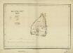
Lahore Fort
India Office reference collection of maps Survey of India
Sheet B [Central & North India], uit: Road map of India
1 : 2027520 titelvariant: North West India; Central & North India; North East India; South India; Annotatie geografische gegevens: De bladen overlappen elkaar gedeeltelijk; Elk blad met bladoverzicht van de hele serie [S.l. : India Tyre & Rubber Company]
Central India.
1 : 3380000 Sharpe, J.
Sheet A [North West India], uit: Road map of India
1 : 2027520 titelvariant: North West India; Central & North India; North East India; South India; Annotatie geografische gegevens: De bladen overlappen elkaar gedeeltelijk; Elk blad met bladoverzicht van de hele serie [S.l. : India Tyre & Rubber Company]
Der Sikh-Staat.
1 : 2200000 Flemming, Carl
Composite: Delhi, Agrah, Oude, Ellahabad.
1 : 750000 Robert Laurie & James Whittle
India 11.
1 : 2217600 Letts, Son & Co.
India XI.
1 : 2200000 Society for the Diffusion of Useful Knowledge (Great Britain)
The Panjab with Part of Afganistan, Kashmeer, Sinde & c
1 : 2200000 Afghánistán Walker, John Walker, Alexander Society for the Diffusion of Useful Knowledge
India 10.
1 : 2217600 Letts, Son & Co.