Maps of Trenčínský
Neubertova generální automapa Republiky československé
1 : 200000 Banská Bystrica (Slovensko : oblast) Soukup, Jan V. Neubert a synové
Mapa země moravské

Mapa země Moravské. S částmi pohraničnými Slezska, Čech, Rakous i Uher
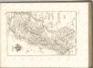
Střední Pováží
Střední Pováží
1 : 200000 Pováží (Slovensko) odbor Klubu českoslov. turistů
Die Markgrafschaft Maehren mit dem Herzogthume Schlesien

C. Trencsin
Slowakei Komitat Trentschin
Markgrafschaft Mähren und Herzogthum Schlesien

Stolice Trenčín. Stolice Turec
Trenčín (Okres), Komitat Martin (Slowakei), ethnische Gruppe
Československo v mapách

Trencsén vármegye térképe
1 : 355000 Trenčín (Slovensko : oblast) Kogutowicz, Manó Magyar Földrajzi Intézet
Comitat Trencsin
1 : 288000 Trenčín-oblast (Slovensko)
Comitat Trencsin
1 : 280000 Trenčín-oblast (Slovensko)
Tabula Generalis Marchionatus Moraviae in sex circulos divisae
1 : 183000 Mollova mapová sbírka Müller, Johann Christoph Gastl, Jan Jiří
Kraj Gottwaldovský

Trentschin 120, uit: Special-Karte von Mittel-Europa / nach amtlichen Quellen bearbeitet von W. Liebenow
1 : 300000 titelvariant: W. Liebenow's Mittel-Europa; Annotatie: Titel boven de bladen: W. Liebenow's Mittel-Europa Johannes Wilhelm Liebenow 1822-1897 Frankfurt a. M. : Ludwig Ravenstein
Generální mapa Protektorátu Čechy a Morava

Marchionatus Moraviae circulus Hradistiensis
1 : 150000 Uherské Hradiště-oblast (Česko) Müller, Johann Christoph Homann, Johann Baptist Ioh. Baptista Homanno
MARCHIONATUS MORAVIAE CIRCULUS HRADISTIENSIS
1 : 150000 Uherské Hradiště-oblast (Česko) Müller, Johann Christoph Homann, Johann Baptist Ioh. Baptista Homanno
MARCHIONATUS MORAVIAE CIRCULUS HRADISTIENSIS
1 : 150000 Uherské Hradiště-oblast (Česko) Müller, Johann Christoph Homann, Johann Baptist Ioh. Baptista Homanno
Marchionatus Moraviae circulus Hradistiensis
1 : 150000 Uherské Hradiště-oblast (Česko) Müller, Johann Christoph Homann, Johann Baptist Ioh. Baptista Homanno
Marchionatus Moraviae circulus Hradistiensis
1 : 150000 Uherské Hradiště-oblast (Česko) Müller, Johann Christoph Homann, Johann Baptist editore Ioh. Baptista Homanno
Marchionatus Moraviae circulus Hradistiensis
1 : 150000 Uherské Hradiště-oblast (Česko) Müller, Johann Christoph Homann, Johann Baptist Ioh. Baptista Homanno
Marchionatus Moraviae circulus Hradistiensis
1 : 150000 Uherské Hradiště-oblast (Česko) Müller, Johann Christoph Homann, Johann Baptist Ioh. Baptista Homanno
Marchionatus Moraviae circulus Hradistiensis
1 : 150000 Uherské Hradiště-oblast (Česko) Müller, Johann Christoph Homann, Johann Baptist Ioh. Baptista Homanno
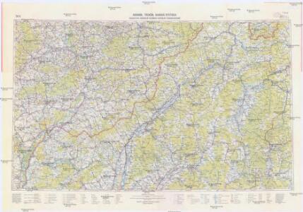
Trenčín
1 : 75000 Slovensko Vojenský zeměpisný ústav
Carte Topographique d'Allemagne.
1 : 220000 Mollova mapová sbírka Jaeger, Johann Wilhelm Abraham Berndt, Johann Christoph Jäger, Johann Wilhelm Abraham
Die Markgraftschaft Mähren
1 : 22000 Uherské Hradiště-oblast (Česko) Schenkl, Conrad Philipp Carl Winiker