Maps of okres Opava
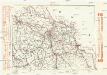
Komunikační mapa země Moravskoslezské
1 : 100000 Moravská Ostrava (Ostrava, Česko) Morslez. zem. výbor
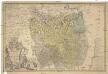
Nova et accurata Geographica Delineatio Ducatus Teschenensis in Silesia Superiore
1 : 158000 Mollova mapová sbírka Nigrin, Jonas Lotter, Tobias Conrad Seutter, Matthäus
Nova et accurata geographica delineatio Ducatus Teschenensis in Silesia superiore
1 : 158000 Cieszyn (Polsko) Lotter, Tobias Conrad T. C. Lotter
Nova et accurata geographica delineatio Ducatus Teschenensis in Silesia superiore
1 : 158000 Cieszyn (Polsko) Seutter, Matthäus Lotter, Tobias Conrad M. Seutter
Sbírka map a diagramů použitých na mírových konferencích v Paříži v letech 1919 - 1920

Dvcatvs in Silesia Svperiore Teschinensis cum adjacentibus regnorum vicinorum, Hungariae videlicet et Poloniae nec non Marchionatus Moraviae etc. Terminis, Mappa specialis :
1 : 158660 Mollova mapová sbírka Nigrin, Jonas Nigrin, Jonas
Nova et accurata geographica delineatio Ducatus Teschenensis...

Nova et accurata geographica delineatio Ducatus Teschenensis...

Teschner Kreis
Principatvs Silesiae Teschinensis
1 : 115000 Těšínské Slezsko Homannianis Heredibus
Sbírka map a diagramů použitých na mírových konferencích v Paříži v letech 1919 - 1920
Principatvs Silesiae Teschinensis nova et accurata delineatio
1 : 130000 Těšínské Slezsko Wieland, Johann Wolfgang ab Homannianis Heredibus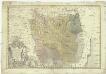
Principatvs Silesiae Teschinensis nova et accurata delineatio distincte insimul exhibens
1 : 125000 Těšínské Slezsko Wieland, Johann Wolfgang Homannianos Heredes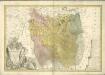

Utilisation de chemins de fer pour le transport des marchandises vers Tchécoslovaquie Pologne
Polsko Čs. voj. zeměpis. ústav
Der Teschner Kreis
1 : 200000 Český Těšín-oblast (Česko) Schenkl, Conrad Philipp Carl Winiker
[Die Markgraftschaft Mähren]
1 : 200000 Český Těšín-oblast (Česko) Schenkl, Conrad Philipp Carl Winiker
Freistadt Bei Teschen.
from Spezialkarte der osterreichisch-ungarischen Monarchie.
Sprachgrenzlandschaft v. Westschlesien, Hultschin, Kuhland
1 : 150000 Hlučínsko Sobotik, Robert
Sbírka map a diagramů použitých na mírových konferencích v Paříži v letech 1919 - 1920
II. vojenské mapování 6
1 : 144000
Der Teschner Kreis
1 : 200000 Český Těšín-oblast (Česko) Schenkl, Conrad Philipp Winiker, Karel Carl Winiker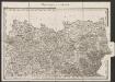
Umgebungen von Teschen
1 : 144000 K.K. Militärisches Geographisches Institut
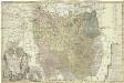
Das Fürstenthum Teschen in Ober-Schlesien
1 : 333300 Mollova mapová sbírka Schleuen, Johann David
Troppau
from Spezialkarte der osterreichisch-ungarischen Monarchie.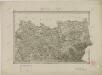
II. vojenské mapování 6
1 : 144000
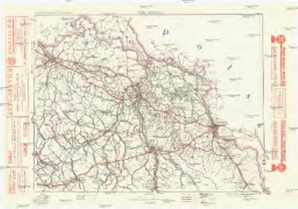
Moravská Ostrava a okolí
1 : 75000 Ostrava (Česko : oblast) Vojenský zeměpisný ústav
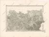
Generální mapa okresního hejtmanství Opavského
1 : 250000 Opava-oblast (Česko) Wagner, Jan Eduard F. Kytka
Freistadt bei Teschen
1 : 75000 Cieszyn (Polsko : oblast) Richter, Aug. K. u. k. Militärgeographisches Institut