Maps of Eastern Uusimaa
Finnland Straßenkarte
1 : 200000 Finsko Gen St d H Abt f Kr Kart u Verm W IV Mil Geo
Kaart van de Zweedse en Russische krygs-verrigtingen in Finland A° 1788
1 : 155000 P. v. Eeusom jnr. sculp.
Kaart van de krygs-verrigtingen der Zweeden en Russen in Finland A°. 1789
1 : 123000 door Roos
Ostsee
1 : 50000 Baltské moře Reichs-Marine-Amt
Kr. Sveaborg i okrestnosti putej vokrug Gel'singforsa
Finnland Suomenlinna Russisch-Schwedischer Krieg <1808-1809>
Afteekening van de Oostzee of Oost Finsche Boodem vertoonende de vaart van Revel tot St. Petersburgh int groot
Gulf of Finland Gerard van Keulen
Kronstadt, Wiborg, Wesenberg
1 : 750000 Kronštadt (Rusko) K. u. k. Militärgeographisches Institut
Afteekening van de Finsche Boodem in de Ost Zee of vaarweg van 't Hoogland tot voor St. Petersborgh
Gulf of Finland Gerard van Keulen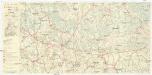
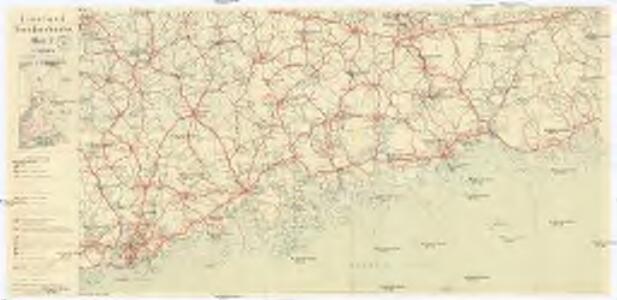
Finnland Straßenkarte
1 : 200000 Finsko Gen St d H Abt f Kr Kart u Verm W IV Mil Geo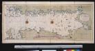
Nieuwe afteekening van de Finlandse Golff
Gulf of Finland Abraham Maas Gerard van Keulen
Oost-Zee Streckende van Dageroort tot Wyborgh [Karte in 2 Teilen], in: De Nieuwe Groote Vermeerderde Zee-Atlas ofte Water-Werelt, S. 27.
1 Karte aus Atlas Doncker, Hendrick
Nieuwe kaart van de Finnissche Golf benevens de omliggende provintien : naar de beste kaarten en sterrekundige waarnemingen geteekend in 't Konigl. Landmeeters Comtoir te Stockholm
1 : 1200000 C. van Baarsel sculp. te Amsterdam : bij J. Covens en Zoon
Die finnischen Seen
Finnland Seengebiet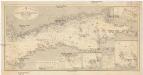
Ostsee
1 : 400000 Baltské moře Reichs-Marine-Amt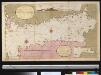
Afteekening van t agterste gedeelte van de Oost Zee van t eijlant Dago tot Schansternij
Gulf of Finland Gerard van Keulen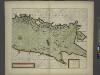
The coast of LYF LAND and East FINLAND from Wolf to Wybourgh and soto Elsenvos
from The sea-atlas : containing an hydrographical description of most of the sea-coasts of the known parts of the world.
Nova et accurata delineatio Ingriae et Careliae cum magna parte Sinus Finnici et Lacus Ladogae, nec non insularum adjacentium
1 : 1210000 Finsko Seutter, Matthäus Matthaeus Seutter
Trigonometrisk grunnlag, vedlegg 65, 10-13: Grunnlagspunkter for Struves meridianbue fra Finnland og Estland
1 : 200000 de Struve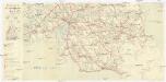
Finnland Straßenkarte
1 : 200000 Finsko Gen St d H Abt f Kr Kart u Verm W IV Mil Geo
Sinus Finnici delineatio geographica / ex quam plurimis subsidiis novissimis stereographice tradita
1 : 1000000 1 Karte auf 2 Blatt : Kupferdruck ; 44 x 81 cm Mayer, Tobias [Homännische Erben]
Russia 3.
1 : 1900800 Letts, Son & Co.
Eisenbahnkarte von Finnland
Finnland Eisenbahnnetz
Karte von Finnland
1 : 2400000 Evropa Finland Steamship
Russland
1 : 3360000 Estonsko Renner Kleinknecht
Carte réduite de la mer Baltique, 2
1 Blatt : 73 x 60 cm Froullé
Schema kʺ pochodamʺ Sv. V. Knjazja Aleksandra Nevskago.
Russland Feldzug Aleksandr Nevskij
Partie, Russie d'Europe. Europe 5.
1 : 1641836 Vandermaelen, Philippe, 1795-1869
Feuille 18 (D III), uit: Carte géologique internationale de l'Europe : la carte, votée au congrès géologique international de Bologne en 1881, est exécutée conformément aux décisions d'une commission internationale, avec le concours des gouvernements, sous le dir. de M.M. Beyrich et Hauchecorne
Annotatie: Blad 48 gamme des couleurs; blad 49: bladwijzer en titelblad Heinrich Ernst Beyrich 1815-1896; Wi. Hauchecorne Berlin : Reimer / (Berlin: Institut lithographique)
Karta Finljandīi s pokazanīem granic Rosīi i Švecīi po raznym dogovorom
1 : 600000 Finnland Nordischer Krieg <1700-1721>