Maps of Finland

Suomi ja Itä-Karjala
1 : 2000000 Finsko Tilgmannin kivipaino
Carte de la partie européene de l'empire de Russie avec l'indication des chemins de poste
1 : 2300000 Finsko Artaria
N. European ports.
1 : 10000000 Philip, George
Geologičeskaja karta Evropejskoj Rossii
1 : 2500000 Nordwest-Blatt Karpinskij, A.P. (Aleksandr Petrovič) Kartografičeskoe zavedenie A.Il'ina
Europaischen Russland I.
1 : 5000000 Handtke, Friedrich H.
Russia 1.
1 : 4435200 Letts, Son & Co.
Prozentualer Anteil der Geldeinkünfte aus Saisonarbeit in St. Petersburg am Einkommen der Bauern in den 30er Jahren des 19. Jahrhunderts nach C.C. Böcker
Finnland Einkommen, Saisonarbeiter
Sweden & Norway, northern, Russia.
1 : 4500000 Society for the Diffusion of Useful Knowledge (Great Britain)
Suomen käsikarta
1 : 2000000 Finsko J.E. & S.G. Rosberg
68. Finlandia.
1 : 3000000 Touring club italiano
Geologische Übersichtskarte von Finland und den angrenzenden Landteilen
1 : 2500000 Sederholm, J.J. F. Tilgman
Finnländische Zuwanderer in St. Petersburg - Paßanträge vom Jahre 1820 in % der Bevölkerung
Finnland, St. Petersburg, Migration
The northern provinces of Sweden and Norway with part I, of Russia
1 : 5000000 Finsko Walker, C. Baldwin & Cradock
La Danimarca Svezia e Norvegia.
Dánsko Seutter, Matthäus Zatta, Antonio Zatta
Übersichtskarte Karelien-Kola
1 : 1000000 Karélie (Rusko) Generalstab des Heeres, Abteilung für Kriegskarten und Vermessungswesen
Ukazanije slavjanskago gorodstva v sevěro-zapadnoj časti Rossii
Finsko
Finnmarchiae et Laplandiae Maritima

Spesielle kart 161c: Kommunekart over Norge med politi og lensmannsdistrikt
1 : 1000
Spesielle kart 162b: Kommunekart over Norge, Med politi og lensmannsdistrikt, Med jurisdiksjonsinndeling
1 : 1000
Distribution des dépôts quaternaires en Finlande
1 : 2000000 Sederholm, J.J. F. Tilgman
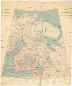
Suomi
1 : 2000000 Finsko Maanmittaushallituksen kivipaino
Suomi
1 : 2000000 Finsko Maanmittaushallituksen kivipaino
No.16. Karta Evropeyskaia Rossiia. Sheet 2
1 : 2000000 Shokalskago,Iu. M.
Suomi
1 : 1000000 Finsko Maanmittaushallituksen kivipaino
La République de Finlande
1 : 2000000 Finsko F. Tilgmann
Spesielle kart 42-2: Rigstelegraf- og Telefonkart over det nordlige Norge
1 : 800000
Feuille 11 (D II), uit: Carte géologique internationale de l'Europe : la carte, votée au congrès géologique international de Bologne en 1881, est exécutée conformément aux décisions d'une commission internationale, avec le concours des gouvernements, sous le dir. de M.M. Beyrich et Hauchecorne
Annotatie: Blad 48 gamme des couleurs; blad 49: bladwijzer en titelblad Heinrich Ernst Beyrich 1815-1896; Wi. Hauchecorne Berlin : Reimer / (Berlin: Institut lithographique)
Trigonometrisk grunnlag, vedlegg 65, 1a: Grunnlagspunkter for Struves meridianbue fra Hammerfest til Jyväskylä
1 : 1440000
Karta Finljandīi s pokazanīem granic Rosīi i Švecīi po raznym dogovorom
1 : 600000 Finnland Nordischer Krieg <1700-1721>