Maps of Bulgaria
Original-Karte von Donau-Bulgarien, dem Balkan und süd.- ost. Serbien
1 : 625000 Bulharsko Kanitz, Felix Philipp Justus Perthes
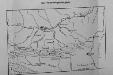
Razpredelenie na vodochetna i dazhdombrni stantsij v balgariya
Bulharsko
Bulgaria. Pergamon World Atlas.
1 : 1500000 Polish Army Topography Service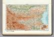
95. Bulgaria. The World Atlas.
1 : 1250000 USSR (Union of Soviet Socialist Republics).
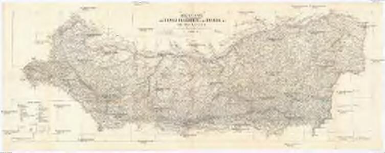
Bulgarien und Ost - Rumelien
Karten zum russisch-türkischen Krieg 1877-1878. Der Hauptkriegsschauplatz
1 : 3000000 Bulgarien Russisch-Türkischer Krieg <1877-1878>
[Bulgarien: Russisch-türkischer Krieg 1877/78]
Bulgarien Russisch-Russisch-Türkischer Krieg <1877-1878>
[Bulgarien: Russisch-türkischer Krieg 1877/78]
Bulgarien Russisch-Russisch-Türkischer Krieg <1877-1878>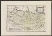
Des Koenigreichs Bulgarien Westliche Hälfte
1 : 1200000 Bulgarien (West)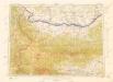
Letecká mapa Evropy

Bulgaria
Mollova mapová sbírka Hoffmann, Johannes Hoffmann, Johann
Theatrum belli inter imperat. Carol VI. et sult. Achmet IV. in partibus regnorum Serviae et Bosniae
Bulharsko Oettinger, Johann Friedrich Hommanianis Heredibus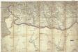
[Jižní Rumunsko]
Rumunsko
Sheet XX: Karte Des Oesterreichischen Kaiserstaates.
1 : 576000 Scheda, Josef
Sofia, Philippopel
1 : 750000 Plovdiv (Bulharsko : oblast) Czerny, Ed. K. u. k. Militärgeographisches Institut
Sofia, Philippopel
1 : 750000 Plovdiv (Bulharsko : oblast) K. k. militär-geographisches Institut
Strassen- und Eisenbahnkarte des oesterreichischen Kaiserthumes
1 : 864000 Blatt 16 Schaller, G. K.K. Militärisch-Geografisches Institut, Karten-Evidenthaltungs-Abteilung
XX, uit: General-Karte des oesterreichischen Kaiserstaates mit einem grossen Theile der angrenzenden Länder / durch Josef Scheda ... bearb. und hrsg
1 : 576000 Annotatie geografische gegevens: Maatstokken: oesterreichische Meilen, geografische oder deutsche Meilen, preussische Meilen, türkische Berri, französische Lieues, russische Werste; Maatstok per blad: wiener Klafter, öster. Meilen; Blad XIX: statistische en taalkundige informatie; Blad XIX: legenda [Wien : K.K. Militärisch-Geografisches Institut]
Generalkarte von Zentraleuropa

Generalkarte von Zentraleuropa

Bulgarisch-rumänische Grenze
1 : 600000 Bulgarien, Rumänien, Grenze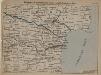
Bulgarisch-rumänische Küste am Schwarzen Meer
1 : 600000 Bulgarien, Rumänien
Generalkarte von Zentraleuropa

Bulgarisch-rumänische Grenze
1 : 600000 Bulgarien, Rumänien, Grenze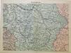
Mittel-Serbien
1 : 875000 Serbien
Thracia
Mollova mapová sbírka Hoffmann, Johannes Hoffmann, Johann
Priština
1 : 200000 Priština (Kosovo) Kartografska radionica
Pleven
1 : 200000 Pleven (Bulharsko) Militärgeographisches Institut
Niš
1 : 200000 Niš (Srbsko) Vojni Geografski Institut Kraljevine
Niš
1 : 200000 Niš (Srbsko : oblast) Kartografska radionica