Maps of Bulgaria
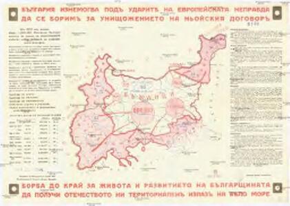
Balgariya iznemogva pod udarit na evropeiskata nepravda da se Borim za uništožhenieto na noiskiya dogovor
Bulharsko Mladežhkata grupa pri Vsebalgarskiya Sayuz Otets Paisij
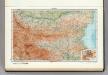
81. Bulgaria.
1 : 1500000 Touring club italiano
Bulgaria et Romania divisa in singulares sangiacatus Silistriam, Nicpolin, Bodinum, Sardiam, Bysantium, Kirkeliam et Gallipolin, una cum finitimus regionibus Valachia, Servia, etc
1 : 1340000 Bulharsko Valk, Gerhard Valk, Leon. G. et L. Valk
Bulgaria et Romania
1 : 1300000 Mollova mapová sbírka Valk, Gerhard Valck, Gerard
Thrakien in der Zeit der Osmanen
Thrakien, Osmanisches Reich, Verwaltungsgliederung Zwick, J.
Bojiště turecko-ruské na Podunají
Balkánský poloostrov
Bojiště turecko-ruské na Podunají
Balkánský poloostrov
Bulgarien mit Ostrumelien und Türk. Thrakien
1 : 864000 Bulharsko Peuckner, Karl Artaria & Co
Bulgarie
1 : 1000000 Bulharsko Service Géographique de l'Armée Britannique
Bulgarie d'après la conférence de Constantinople1876-1877
Bulgarien
Macedonia et Thracia.
1 : 5700000 Fenner, Rest.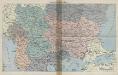
Balkan-Uebersichtskarte
1 : 2250000 Balkanhalbinsel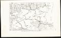
Karta priložena pri San-Stefanskija dogovor, 1878 g.
Bulgarien San Stefano
[Balkan]
1 : 3000000 Bulgarien, Balkanhalbinsel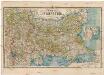
Karta na Bălgaria
Bulharsko Toškov, Pančo
Perechod čerez Balkany v dekabrě 1877 g.
Bulgarien Russisch-Türkischer Krieg <1877-1878> Balkan
Thracia Antiqua
1 : 1700000 Mollova mapová sbírka Weigel, Christoph Weigel, Christoph I.
[Die Balkan-Halbinsel, Blatt 2]
Adolf Stieler's Handatlas über alle Theile der Erde und über das Weltgebäude Stieler, Adolf Justus Perthes
Exactissima Tabula, qua tam Danubii Fluvii Pars Inferior
1 : 2000000 Mollova mapová sbírka Visscher, Nicolaes Jansz. Schenk, Peter II
Bulgaria. Pergamon World Atlas.
1 : 1500000 Polish Army Topography Service
Razpredelenie na vodochetna i dazhdombrni stantsij v balgariya
Bulharsko
Geographisch-historische Karte des Kriegsschauplatzes in Europa in den Jahren 1828 u. 1829
Bulharsko Ehrenkreutz, Br. von Deberghes C. V. Sommerlatt
95. Bulgaria. The World Atlas.
1 : 1250000 USSR (Union of Soviet Socialist Republics).
Bulgarien und Ost - Rumelien

XII, uit: General-Karte von Mittel-Europa in 12 Blättern, im Masse 1:1.200.000 / entworfen, bearb. und hrsg. von Josef Schlacher
1 : 1200000 Annotatie: Blad 6 ontbreekt; Annotatie geografische gegevens: 21 maatstokken op blad 9; Legenda op blad 9 Wien : K.K. Militär Geografisches Institut
(Europaischen Turkei) 4.
1 : 1580000 Berghaus, Heinrich; Flemming, Carl; Handtke, Friedrich H.; Sohr, Karl
Charte der Wallachen Bulgarien's und Thracien's
Bulharsko Haubenstricker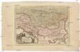
Pannonia Mizija, Dacija Illirik
1 : 1110000 Dácie Orfelin, Zaharija