Maps of Brod
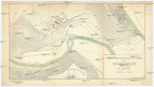
Stereophotogrammetrische Aufnahme des Treskatales (Neuserbien) im Jahre 1914
1 : 2000 Makedonie Konsortium Luftbild, Stereographik
Karta okresnostej Ochridskago i Prespanskago ozer
Ohrid-oblast (Makedonie) Grigorowič
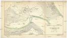
Vormarsch der 1. Armee nach der Schlacht bei Kumanowo bis zur Schlacht bei Bitolj (Monastir)
Makedonien Balkankrieg <1912-1913> Kumanovo / Schlacht
Atlante veneto
Albanien Venezia (bis 1797)
[Nordalbanien]
Albanien
Süd-Serbien
1 : 800000 Serbien (Süd)
Ligne de partage d'après la carte annexée au Traité d'Alliance
Bulgarien Serbien Balkankrieg <1912-1913> Territorialer Anspruch Th. Weinreb del.
Ligne de partage d'après la carte annexée au traité d'alliance
Balkanhalbinsel Grenze Balkankrieg <1912-1913> Annexion
Carte des écoles et églises du vilayet de Monastir (1908)
Makedonien Vilâyet Manastır Osmanisches Reich Kirchenbau Schulgebäude Kümmerly & Frey
Atlas
Albanien
Generalkarte
Albanien
Demarkationslinie vor Beginn der Kriege gegen die Bulgaren
Südosteuropa Balkankrieg <1912-1913> Grenze
Mappa geographica Graecia septentrionalis hodiernae etc.
Griechenland Albanien
Nord- und West-Albanien nach den Beobachtungen des k.k. Kreisphysikers Dr. J. Müller 1844
Albanien
Carte de l' Albanie
Albánie Karacsay, Fedor
Veles, Priština, Scutari
1 : 750000 Priština (Kosovo) Konrad, A. Erben, Fr. K. u. k. Militärgeographisches Institut
Albanie (Races et Religions)
Albanien Ethnische Gruppe Denomination
G. Freytags Karte des Fürstenthums Albanien
1 : 600000 Albánie Freytag, Gustav Kartogr. Anstalt G. Freytag & Berndt
[Černá Hora, Srbsko a Makedonie]
Albánie
Shqiperia
1 : 500000 Albánie
Albania
1 : 500000 Albánie Consociazione turistica italiana
Turquie d'Europe
Albanien Osmanisches Reich Reich
Karte von Albanien
1 : 1480000 Albánie
[Mazedonien]
Makedonien
Karte der Flußgebiete des Drin und des Wardar
1 : 500000 Vardar-Gebiet Flusssystem Hahn, Johann Georg von
Hungaria
Albanien Ungarn
Übersichtskarte von Mittel - Europa

Novus Atlas
Albanien
Carte generale
Albanien