Maps of Lienz

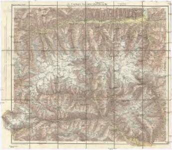
G. Freytag's Touristen-Wanderkarte
1 : 100000 Vysoké Taury (Rakousko : pohoří) Freytag, Gustav G. Freytag & Berndt
Touristen-Wanderkarte
1 : 100000 Benátské Alpy (Itálie) G. Freytag & Berndt
Grosz-Glockner.
from Spezialkarte der osterreichisch-ungarischen Monarchie.
Special-Karte der Gross-Glockner-Gruppe
1 : 50000 Grossglockner (Vysoké Taury, Rakousko : hora) Deutscher und Österreichischer Alpenverein
Special-Karte der Gross-Glockner-Gruppe
1 : 50000 Petters, Hugo Deutscher und Oesterreichischer Alpenverein
Special-Karte der Venediger-Gruppe
1 : 50000 Petters, Hugo ; Purtscheller, L. Deutscher und Oesterreichischer Alpenverein
Lienz.
from Spezialkarte der osterreichisch-ungarischen Monarchie.
Special-Karte der Gross-Glockner-Gruppe
1 : 50000 Petters
Special-Karte der Gross - Glockner - Gruppe

Karte der Glockner Gruppe
1 : 60000 Grossglockner (Vysoké Taury, Rakousko : hora) Wiedenmann, P. J. Lindauer'sche Buchhandlung
Granatspitzkarte des Deutschen Alpenvereins
1 : 25000 Granatspitzen (Vysoké Taury, Rakousko : pohoří) Hauptvermessungsabteilung 14
[Grossglockner]
1 : 25000 Grossglockner (Vysoké Taury, Rakousko : hora)
Hopfgarten in Defereggen
1 : 50000 Tyrolsko (Rakousko) Kartographisches Institut
Oberes Defereggental
1 : 25000 Tyrolsko (Rakousko) Kartographisches, früher Militärgeographisches Institut
Groszglockner
1 : 25000 Grossglockner (Vysoké Taury, Rakousko : hora) Hauptvermessungsabteilung XIV
Matrei
1 : 25000 Hauptvermessungsabteilung XIV
Matrei in Osttirol
1 : 25000 Kartographisches Institut
Kitzsteinhorn
1 : 25000 Hauptvermessungsabteilung XIV
Kitzsteinhorn
1 : 25000 Kartographisches Institut
Tauernkogel
1 : 25000 Hauptvermessungsabteilung XIV
Hopfgarten in Defereggen
1 : 25000 Kartographisches Institut
St. Veit in Defereggen
1 : 25000 Kartographisches Institut
Hohe Fürlegg
1 : 25000 Hauptvermessungsabteilung XIV
Prägraten
1 : 25000 Hauptvermessungsabteilung XIV
Dorf Fusch
1 : 25000 Kartographisches Institut
Winkl Heiligenblut
1 : 25000 Kartographisches Institut
St. Jakob in Deferengen
1 : 25000 Hauptvermessungsabteilung XIV
Trojer Alpe
1 : 25000 Alpy rakouské (pohoří : oblast) Hauptvermessungsabteilung XIV
Unterstaller Alpe
1 : 25000 Alpy rakouské (pohoří : oblast) Hauptvermessungsabteilung XIV