Maps of Drobeta-Turnu Severin

Oršava
1 : 200000 Oršava (Rumunsko) Kartografska radionica
Krassova und Teregova.
from Spezialkarte der osterreichisch-ungarischen Monarchie.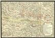
Action de Mehadia Gagne Svr les Infideles par les Trouppes Imperiales le 15. Iuillet 1738
Mollova mapová sbírka Geyer
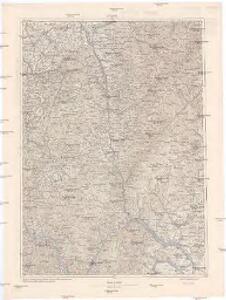
Zone 25, Kol. XXVI, Krassova und Teregova, uit: [Geologische Specialkarte der im Reichsrathe vertretenen Königreiche und Länder der österreichisch-ungarischen Monarchie] / geologische Aufnahmen der königl. ung. Geologischen Anstalt
1 : 75000 Annotatie: Verantwoordelijkheidsvermelding in 1909 veranderd in: Königliche Ungarische Geologische Reichsanstalt; Sommige bladen in het Frans; Annotatie geografische gegevens: Coördinaten gebaseerd op nulmeridiaan van Ferro (Hierro) Königliche Ungarische Geologische Reichsanstalt; Königliche Ungarische Geologische Anstalt Budapest : [Königliche Ungarische Geologische Anstalt]
Mehadia
1 : 75000 Mehadia Geripp: Assist. Scherling. Terrain: Feuerwkr. Kotrtsch
Bozovics
1 : 75000 Bozovici Geripp: Obejäger Dannerer. Terrain: Lieut. Tschofen
Krassova und Teregova
1 : 75000 Caraşova, Caraş-Severin Geripp: Offic. Höller u. Offic. M. Jakupec. Terrain: Oblt. G. Brenner u. Lieut. Sied
Somosréve
1 : 75000 Caraş-Severin Geripp: F. Kohout. Terrain: Feldw. Maschka
Mehadia.; Spezialkarte der osterreichisch-ungarischen Monarchie.
from Spezialkarte der osterreichisch-ungarischen Monarchie. Austro-Hungarian Monarchy. Militärgeographisches Institut.,
Bozovics.; Spezialkarte der osterreichisch-ungarischen Monarchie.
from Spezialkarte der osterreichisch-ungarischen Monarchie. Austro-Hungarian Monarchy. Militärgeographisches Institut.,
Kornyareva.; Spezialkarte der osterreichisch-ungarischen Monarchie.
from Spezialkarte der osterreichisch-ungarischen Monarchie. Austro-Hungarian Monarchy. Militärgeographisches Institut.,
Borlova und Klopotiva.; Spezialkarte der osterreichisch-ungarischen Monarchie.
from Spezialkarte der osterreichisch-ungarischen Monarchie. Austro-Hungarian Monarchy. Militärgeographisches Institut.,
Karánsebes und Resicabánya
1 : 75000 Reșița, Caransebeş Geripp: Fwkr. Krainz. Terrain: Hauptm. Pitron u. Oblt. Trica
Borló und Klopotiva
1 : 75000 Caraş-Severin Geripp: F. Kohout. Terrain: Oberlt. Sachs
Orsova und Turnu-Severin
1 : 75000 Orșova, Drobeta- Turnu Severin Geripp: Oberjgr. J. Richter u. Offiz. M. Jakupec. Terrain: Oberlt. Trica u. Oberlt. Rud. Bayer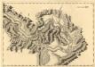
Sectio XIV Widdin - Stanna
Mollova mapová sbírka Marsili, Luigi Ferdinando
Karansebes und Resicabanya.
from Spezialkarte der osterreichisch-ungarischen Monarchie.
Orsova und Turnu-Severin.
from Spezialkarte der osterreichisch-ungarischen Monarchie.
Berzászka und Óasszonyrét
1 : 75000 Banat Geripp: Offiz. E. Schill u. Offiz. M. Jakupec. Terrain: Oberlt. C. Mirilović u. Oberlt. R. Machold
Berzaszka und O-Ogradina.
from Spezialkarte der osterreichisch-ungarischen Monarchie.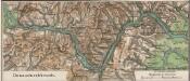
Donaudurchbruch
1 : 500000 Eisernes Tor, Donau (Region)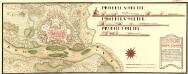
Neies Proiect von Vipalanka von Herren Obrist Lieutinant Rochet dem Hoff Krigs Rath übergeben vnd von den Selben aprobirt MDCCXI
Mollova mapová sbírka Geyer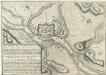
Plan nouveau tres exacte de Vipalanka
Mollova mapová sbírka
Lambert-Cholesky sheet 2154 (Delineşti)
1 : 20000 Romanian military topographic map sheet under Lambert-Cholensky projection Serviciul Geografic al Armatei geo-spatial.org Serviciul Geografic al Armatei
Lambert-Cholesky sheet 2153 (Cuptoare Secu)
1 : 20000 Romanian military topographic map sheet under Lambert-Cholensky projection Direcția Topografică Militară geo-spatial.org Direcția Topografică Militară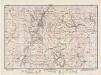
Lambert-Cholesky sheet 2152 (Valiug)
1 : 20000 Romanian military topographic map sheet under Lambert-Cholensky projection Direcția Topografică Militară geo-spatial.org Direcția Topografică Militară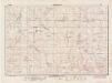
Lambert-Cholesky sheet 2151 (Capul Munţilor)
1 : 20000 Romanian military topographic map sheet under Lambert-Cholensky projection Direcția Topografică Militară geo-spatial.org Direcția Topografică Militară
Lambert-Cholesky sheet 2254 (Caransebeş)
1 : 20000 Romanian military topographic map sheet under Lambert-Cholensky projection Direcția Topografică Militară geo-spatial.org Direcția Topografică Militară
Lambert-Cholesky sheet 2150 (Piatra Motovei)
1 : 20000 Romanian military topographic map sheet under Lambert-Cholensky projection Direcția Topografică Militară geo-spatial.org Direcția Topografică Militară