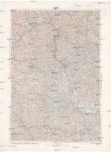
Maps of Graz-Umgebung

Gradec
1 : 200000 Štýrský Hradec (Rakousko : oblast) Kartografska radionica
Neueste special Karte des Gratzer Kreises im Herzogthume Steyermark
1 : 213000 Štýrsko (Rakousko) Kaiser, Joseph Franz Jos. Fr. Kaiser
Neueste special Karte des Gratzer Kreises im Herzogthume Steyermark
1 : 200000 Štýrsko (Rakousko) Kaiser, Jos. Fr. Jos. Fr. Kaiser
Karte der Umgebung Graz
1 : 150000 Štýrský Hradec (Rakousko : oblast) Reis, Johann Georg Rothaug, Johann Georg Kartogr. Anst. von G. Freytag & Berndt
Stÿriae Ducatus Fertilisimi Nova Geographica Descriptio
1 : 200000 Mollova mapová sbírka Vischer, Georg Matthaeus Trost, Andreas
Yugoslavia 1:100,000, Maribor
Yugoslavia 1:100,000 , Series GSGS 4396. Great Britain. War Office. [London] : War Office
Wildon und Leibnitz.
from Spezialkarte der osterreichisch-ungarischen Monarchie.
Graz.
from Spezialkarte der osterreichisch-ungarischen Monarchie.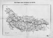
Das Drauland zwischen U.-Drauburg und Marburg
1 : 200000 Drau-Gebiet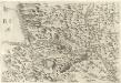
Stÿriae Ducatus Fertilisimi Nova Geographica Descriptio
1 : 200000 Mollova mapová sbírka Vischer, Georg Matthaeus Trost, Andreas
Neuester Situations - Plan von Gratz und seine umgebungen

Yugoslavia 1:100,000, Slovenji Gradec
Yugoslavia 1:100,000 , Series GSGS 4396. Great Britain. War Office. [London] : War Office
Flurkarte des steirischen Draulandes bis zur Drauenge
1 : 2880 Drau-Gebiet
Koflach und Voitsberg.
from Spezialkarte der osterreichisch-ungarischen Monarchie.
Entwicklung von Grenzen im Drauland
Drau-Gebiet Grenzen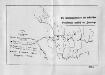
Die Siedlungsformen des steirischen Draulandes westlich der Drauenge
Drau-Gebiet Siedlungsform
D. Landsberg und Wolfsberg.
from Spezialkarte der osterreichisch-ungarischen Monarchie.
Marburg.
from Spezialkarte der osterreichisch-ungarischen Monarchie.
Unterdrauburc
1 : 75000 Dravograd
Birkfeld.
from Spezialkarte der osterreichisch-ungarischen Monarchie.
Unt. Drauburg.
from Spezialkarte der osterreichisch-ungarischen Monarchie.
Leoben und Bruck a.d. Mur.
from Spezialkarte der osterreichisch-ungarischen Monarchie.
Waldkarte des Draulandes bis zur Drauenge
1 : 75000 Drau-Gebiet Bewaldung
Ausflugskarte im Schöcklgebiet

Plan der kaiserlich königliechen Provinzial-Hauptstadt Gratz samt ihren Umgebungen in Herzogthume Steyermark
1 : 2800 Štýrský Hradec (Rakousko) Kaiser, Jos. Fr. Jos. Fr. Kaiser
Plan der k.k. provinzial Hauptstadt Graetz sam[m]t ihren Umgebungen
1 : 14600 Štýrský Hradec-oblast (Rakousko) Kaiser, Josef Franz J.F. Kaiser
Maria Trost
1 : 25000 Hauptvermessungsabteilung XIV
Peggau
1 : 25000 Kartographisches Institut
Peggau
1 : 25000 Hauptvermessungsabteilung XIV