Maps of Trient

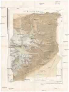
Massif du Trient
1 : 50000 Mont Blanc (Francie a Itálie) Barbey, Albert Imfeld, Xaver Kümmerly & Frey
Süd-Wallis
1 : 50000 8 Karten Topogr. Anstalt v. Wurster, Randegger & Co. ; gestochen von R. Leuzinger Topogr. Anstalt v. Wurster, Randegger & Co., Winterthur
Massif du Talefre
1 : 50000 Mont Blanc (Francie a Itálie) Barbey, Albert Imfeld, Xaver Kümmerly & Frey
Col du Gd. St. Bernard
1 : 50000 Service topographique fédéral
La chaine du Mont-Blanc : carte au 1/50.000ème / dressée ... par X. Imfeld ; d'après les relevés, les mensurations et la nomenclature de Louis Kurz et d'après les documents existants ; gravé et imp. par Kümmerly frères, Berne ; rochers par R. Leuzinger
1 : 50000 Annotatie: In opdracht van Albert Barbey, président de la section des Diablerets du Club Alpin Suisse; Facs. van de uitg.: 1896; Annotatie geografische gegevens: Noordwest boven Imfeld, X.; Kurz, Louis; Leuzinger, Rudolf; Kümmerly, Bern [Murten : Cartographica Helvetica]
chaîne du Mont Blanc
1 : 50000 Barbey, Albert ; Kurz, Louis ; Imfeld, Xaver ; Leuzinger, Rudolf ; Kümmerly, Hermann Kümmerly frères
Blatt XXII: Martigny, Aoste, uit: Topographische Karte der Schweiz / vermessen und hrsg. ... unter Aufsicht des Generals G.H. Dufour
1 : 100000 Annotatie: Met plaatsnamenregister (bl. V), bladwijzer (bl. XXI) en hoogteregister (bl. XXV); Voor aanwezige bladen zie overzichtsblad Dufour, G. H. [Bern : Eidg. Topogr. Bureau]
Rhodani progressus per Vallesiam
1 : 100000 1 Karte a Joanne Jacobo Scheuchzero sumptibus Petri vander Aa, Lugd. Bat. [i.e. Leiden]
Rhodani progressus per Vallesiam
1 : 100000 1 Karte juxta observationes proprias factas in Itinere Alpino a Joanne Jacobo Scheuchzero sumptibus Petri vander Aa, Lugd. Bat. [i.e. Leiden]
Topographische Karte der Schweiz
1 : 100000 25 Karten vermessen und hrsg. auf Befehl der Eidgenössischen Behörden ; aufgenommen unter der Aufsicht des Generals G.H. Dufour Eidg. Topographisches Bureau, [Genève], [später: Bern]
Montblanc - Gebirge
Geologischer Atlas zur Naturgeschichte der Erde Leonhard, Carl Cäsar von E. Schweizerbart'sche Verlagsbuchhandlung
Mt. Blanc, Grd. St. Bernard
1 Vogelschaukarte Orell Füssli, Zürich
Carte de la Vallée de Sales
1 : 20000 Alpy francouzské (pohoří) Perret, Robert Barrere, Henry Institut Cartographique
Bez titulu: Alpy
Carte de la Chaine du Mont Blanc
1 : 50000 Mont Blanc (Francie a Itálie) Gaillard, E.
Martigny, Aoste
1 : 100000 1 Karte geologische Aufnahme von H. Gerlach [Wurster & Randegger], [Winterthur]
Karte der Thäler von Bagne, Nendaz u. Hérémence im Wallis
1 : 300000 1 Karte G. St. Topogr. Anstalt v. J. Wurster u. Comp., [Winterthur]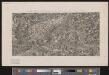
[Malerisches Relief der Schweizer- und angränzenden Alpen]
1 : 135000 11 Vogelschaukarten Nach der Natur aufgenommen und gezeichnet von F.W. Delkeskamp ; gestochen v. Knopfmacher u. J.Ph. Dauch [Friedrich Wilhelm Delkeskamp], [Frankfurt am Main]
Aosta
1 : 200000 Herder, Bartholomew

Carte du païs de Vallais, ou Wallisser-land
1 Karte : Kupferdruck ; 35 x 44 cm Valck; Schenk; Duval apud G. Valk et P. Schenk
Atlas Suisse
1 : 120000 16 Karten levé et dessiné par J.H. Weiss [et Joachim Eugen Müller] aux frais de J.R. Meyer à Aarau dans les années 1786 à 1802 ; gravée [sic] par [Christophe] Guérin, [Matthias Gottfried] Eichler et [Johann Jakob] Scheurmann [Johann Rudolf Meyer], Aarau
Original von Keller's zweiter Reisekarte der Schweiz
1 : 500000 1 Karte in 4 Teilen gest. v. J. Scheurmann Keller, Zürich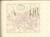
Valesiae Altera et VII. Nova Tabula. [Karte], in: Claud. Ptolemaeus. Geographia lat. cum mappis [...], S. 356.
1 Karte aus Atlas Münster, Sebastian [und Ptolemaeus, Claudius]
Vallesia Superior, ac Inferior Wallis le Valais, geographice repraesentata
1 : 200000 Mollova mapová sbírka Walser, Gabriel Homann, Johann Baptista - dědici
Carte du Pais de Vallais ou Wallis Ser-Land
1 : 250000 Mollova mapová sbírka Duval, Pierre Schenk, Peter I
Carte géologique des parties de la Savoie, du Piémont et de la Suisse voisines du Mont Blanc
1 : 150000 Favre, Alphonse Etablissement topographique de J. Wurster et Cie.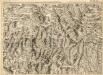
Environs de la Boneville et de Martinach
1 : 240000 Mollova mapová sbírka Dheulland, Guillaume Dheulland, Guillaume