Maps of Cuneo
Carta d'Italia speciale per automobilisti, ciclisti e touristi
1 : 250000 Cuneo (Itálie) Istituto Italiano d'arti grafiche
Bez titulu:Itálie

Le Theatre de Bellone :
Mollova mapová sbírka Schenk, Pieter Braakman, Adriaan
Partie du Briançonnois, du Graisivaudan, du Gapençois et l'Ambrunois dans le Daufiné
1 : 250000 Mollova mapová sbírka Jaillot, Alexis-Hubert Jaillot, Alexis Hubert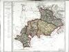
Département des Hautes Alpes
1 Karte : Kupferdruck ; 48 x 52 cm Houdan; Dumez chez Dumez directeur de l'atlas national de France rue de la Harpe no. 26
Carte des départements des Hautes Alpes de l'Isere, et de la Drome, no. 4
1 Blatt : s.n.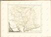
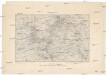
152 Embrun.
1 : 86400 Cassini family; Cassini, Cesar-Francois, 1714-1784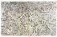
[Embrun - Gap]
1 Blatt : 56 x 89 cm s.n.
Govverneme[n]t d'Embrun
1 Karte : Kupferdruck ; 11 x 15 cm Sebastian Cramoisy
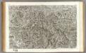
Carta Topographica da Torino sino a Cuneoconsuoi camini fiumi Torenti et Seoladici
Mollova mapová sbírka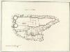
Castello di Savorgio
Mollova mapová sbírka
151 Briancon.
1 : 86400 Cassini family; Cassini, Cesar-Francois, 1714-1784
166 Queyras.
1 : 86400 Cassini family; Cassini, Cesar-Francois, 1714-1784
167 Larche.
1 : 86400 Cassini family; Cassini, Cesar-Francois, 1714-1784
[Larche]
1 Blatt : 56 x 29 cm s.n.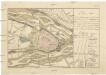
Plan von der Belagerung der Stadt und Festung Cuneo in Piemont welche durch die k.k. Truppen unter Comando sr. fürstlichen Durchlaucht Herrn F.M.L. Fürsten von Lichtenstein belagert worden, wo von 25.ten auf den 26.ten 9.ber Nachts die transcheé eröfnet und den 3.ten December [1]799 die Festung mit Capitulation übergangen
Cuneo (Itálie)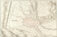
Quillestre. Piemont
Mollova mapová sbírka
Carmagnole
Mollova mapová sbírka Fer, Nicolas de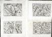
Govverneme[n]t de Gap et Puymore
1 Karte : Kupferdruck ; 11 x 15 cm Sebastian Cramoisy
[Queyraz]
1 Blatt : 56 x 48 cm s.n.
Carte de la France... Feuille XXVII - 32
Briançon
1 : 80000 Service géographique de l'armee
36) XII.N.E. ''Turin'', uit: Carte géologique de France
1 : 500000 Annotatie: Voor aanwezige bladen zie bladoverzicht [S.l : s.n.]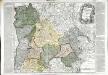
Le gouverneme[n]t du Dauphiné
1 Karte : Kupferdruck ; 48 x 57 cm Bailleul; Daudet chez Daudet grande rue Merciere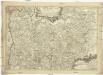
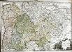
Le Dauphiné distingué en principales parties et regions selon les memoires les plus recents
1 : 530000 Dauphiné (Francie) Fer, Nicolas de Danet, Guillaume Danet
Frontieres de France et d'Italie pour les campagnes du Marechal de Berwick
1 Karte : Kupferdruck ; 31 x 17 cm Buache de la Neuville s.n.
Sabavdia Dvcatvs
1 : 740000 Mollova mapová sbírka Merian, Matthaeus Merian, Matthäus
Dauphine sive Delphinatus superior et inferior
1 Karte : Kupferdruck ; 49 x 57 cm Seutter Matthäus Seutter
Dauphine sive Delphinatus superior et inferior
1 Karte : Kupferdruck ; 48 x 57 cm Lotter Tobias Konrad Lotter