Maps of Dinaric Alps

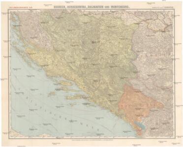
Bosnien, Herzegowina, Dalmatien und Montenegro
1 : 600000 Bosna Handtke, Friedrich Carl Flemming
Bosnien, Herzegowina, Dalmatien und Montenegro
1 : 600000 Bosna Handtke, Friedrich Carl Flemming
Yugoslavia Selected Areas. Pergamon World Atlas.
1 : 1250000 Polish Army Topography Service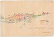
Kreiseinteilung von Dalmatien
Dalmatien Verwaltungsgliederung Jabornigg von Altenfels, Rudolf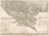
Das Oesterreichische-Kaiserthum

Special-Karte von Bosnien, der Herzegowina, dem Fürstenthum Montenegro und dem österreichischen Kronlande Dalmatien
1 : 600000 Bosna Handtke, Friedrich C. Flemming
Special-Karte von Bosnien, der Herzegowina, dem Fürstenthum Montenegro und dem österreichischen Kronlande Dalmatien
1 : 600000 Bosna Handtke, Friedrich C. Flemming
Bosnien und Dalmatien
1 : 800000 Bosna Kiepert, Heinrich Boués, A. Geographisches Instituts
Bosnien und Dalmatien
1 : 800000 Bosna Kiepert, Heinrich Boués, A. Geographisches Instituts
[Kaart], uit: Bosnien, Herzegowina, Dalmatien und Montenegro / bearb. von F. Handtke
1 : 600000 titelvariant: General-Karte von Bosnien, der Herzegowina, Montenegro und Dalmatien; Annotatie: Omslagtitel: General-Karte von Bosnien, der Herzegowina, Montenegro und Dalmatien Friedrich H. Handtke 1815-1879 Glogau : Carl Flemming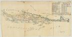
Uebersicht der Distanzen und Peripherien von Dalmazien und den hierzu gehörigen Inseln
1 : 646768 Dalmatien Vetter von Lilienberg, Wenzel Alois Jabornigg von Altenfels, Rudolf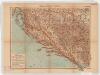
Dalmatien, Bosnien und Hercegovina. Sonderkarte 4
1 : 1000000 Relief shown by hachures and spot heights. Depths shown by isolines and soundings. Shows cities with populations, villages, main roads, railroads, forts and fortresses, beacons and telegraph lines. Language German Velhagen & Klasing Bielefeld and Leipzig: Velhagen & Klasing
Dalmatien, Montenegro.
1 : 1130000 Flemming, Carl
Carta Orografica della Dalmazia
Dalmatien, Montenegro, Relief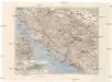
[Bosna a Hercegovina]
1 : 1500000 Bosna a Hercegovina Srp, Jan Klub českých turistů
Katastralkarte
Dalmatien Katasterplan Jabornigg von Altenfels, Rudolf
General-Karte von Dalmatien, Bosnien, der Hercegovina und Montenegro
1 : 750000 Bosna R. Lechner
Generalkarte von Bosnien und der Hercegovina nebst Dalmatien
1 : 864000 Bosna Peucker, Karl Artaria
Dalmatia et regiones adjacentes, Croatia, Bosnia, Slavonia, Servia, Albania, accurate descriptae
1 : 1260000 Albánie Monath, Peter Konrad Petr Conr. Monath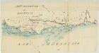
Carta Idrografika della Dalmazia
Dalmatien Hydrologie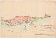
Übersichtskarte des vecchio, nuovo e nuovissimo Acquisto
Dalmatien Jabornigg von Altenfels, Rudolf

Dalmacie a země zavládnuté

Dalmatia et regiones adjacentes, Croatia, Bosnia, Slavonia, Servia, Albania, accurate descriptae
1 : 1250000 Mollova mapová sbírka Monath, Peter Konrad Monath, Peter Konrad
Dalmacie [sic], Bosna a Hercegovina
1 : 1500000 Bosna Milbauer, Vl. Otto, Jan J. Otto
Austria 3.
1 : 1774080 Letts, Son & Co.
Karte des Königreiches Dalmatien


Dalmatien, Bosnien und Hercegovina