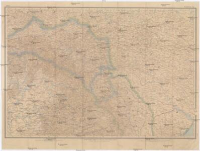
Maps of Carpathian Mountains

Österreich-Ungarische Monarchie
1 : 1000000 Evropa jihovýchodní R. Lechner
Galizien und das Fürstentum Moldau (16./17. Jahrhundert)
Moldau (Fürstentum), Galizien
Danvbivs, Fluvius Europae Maximus
Mollova mapová sbírka Danckertsz, Cornelis Danckerts, Cornelis I. - dědici
Li palatinati della Russia rossa Podolia e Wolhynia
1 Karte : Kupferdruck ; 31 x 40 cm Zatta; Zuliani; Pitteri; Rizzi-Zannoni presso Antonio Zatta
Li palatinati della Russia rossa Podolia e Wolhynia / tratta dall'atlante polac[c]o del Sig[no]r Riz
1 : 1500000 1 Karte : Kupferdruck ; 31 x 40 cm Zuliani, Giuliano presso Antonio Zatta
Principatus Valachiae, Moldaviae, et Transylvaniae, divisus in singulares Populos cum finitimis Regionibus distinete ostenduntur
1 : 1100000 Mollova mapová sbírka Valk, Gerhard Valck, Gerard
Karte der Moldau und der angrenzenden Länder Oesterreichs (Ostgalizien und Siebenbürgen), Russlands (Bessarabien, Podolien, Volhynien, Kiew), dann der Wallachei und Dobrudscha
1 : 1500000 Besarábie (Moldavsko a Ukrajina)
[Západní Ukrajina]
Ukrajina západní Benedicti, Hieronymus
VIII, uit: General-Karte von Mittel-Europa in 12 Blättern, im Masse 1:1.200.000 / entworfen, bearb. und hrsg. von Josef Schlacher
1 : 1200000 Annotatie: Blad 6 ontbreekt; Annotatie geografische gegevens: 21 maatstokken op blad 9; Legenda op blad 9 Wien : K.K. Militär Geografisches Institut
Reliefkarte von Galizien und Süd-Polen

Transilvania, Moldavia, Valachia, Bulgaria &c / by Rob.t Morden
1 : 6400000 1 Karte : Kupferdruck ; 9 x 11 cm (ganze Seite: 20 x 16 cm) Morden, Robert [Verlag nicht ermittelbar]
Partie septent.le de la Russie d'Europe / gravé par Chamouin ; ecrit par Giraldon
1 : 8000000 1 Karte : Kupferdruck ; 21 x 29 cm Chamouin, Jean Baptiste Marie [Verlag nicht ermittelbar]
Russia in Asia / drawn by Wyld ; Hewitt Sc.
1 : 31680000 1 Karte : Kupferdruck ; 21 x 28 cm Wyld, James John Thomas & Co.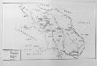
Die Moldau
Moldau (Fürstentum)
Partie septentrio.le et meridionale de la Russie européenne Tartarie russienne et Petite Tartarie
1 : 13000000 1 Karte : Kupferdruck ; 23 x 21 cm [Collége de Maître-Gervais]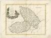
Principati di Moldavia

Generalkarte Des Russischen Reichs mit der Eintheilung in die neu errichteten Statthalterschaften un
1 : 5600000 1 Karte auf 3 Blatt : Kupferdruck ; 79 x 171 cm ; Einzelbl. 79 x 57 cm Schraembl, Franz Anton Zu finden im eigenen Verlage in Wien
Austrian Dominions II.
1 : 1760000 Society for the Diffusion of Useful Knowledge (Great Britain)
Austrian Empire 2.
1 : 1774080 Letts, Son & Co.
Tabula geographica continens despotatus Wallachiae atque Moldaviae, provinciam Bessarabiae sub clientela Turcica, itemque provinciam polonicam Podoliae
1 : 1500000 Besarábie (Moldavsko a Ukrajina) ab Homannianis Heredibus
Gouv. 34. Wilna, 35. Grodno, 36. Bialystock
1 : 2300000 1 Karte : Lithographie ; 26 x 19 cm Schlieben, W.E.A. von [Georg Joachim Göschen]
Tabula Geographica
1 : 1600000 Mollova mapová sbírka Homann, Johann Baptist Homann, Johann Baptista - dědici
Novaja karta naměstničestv / Soč. J. Treskot
1 : 10900000 1 Karte : Kupferdruck ; 30 x 19 cm Truskot, Ivan Fomič [Verlag nicht ermittelbar]
Übersichtskarte von Rumänien
1 : 750000 Rakousko-Uhersko k. u. k. Hof- und Universitätsbuchhandlung R. Lechner (W. Müller)
Carte Nouvelle des Royaumes de Galizie et Lodomerie, avec le District de Bukowine.
From Poland
Karte von der Moldau, Wallachei u. Siebenbürgen nebst Theilen der angränzenden Länder
1 : 1863880 Moldavsko Handtke, Friedrich Flemming, C. C. Flemming
Karte des Oesterreichisch - ungarischen Reiches

Théatre de la guerre actuelle, en Allemagne, en Pologne et en Turquie. n12, Iassi
1 : 900000 Chanlaire, Pierre Grégoire 1758-1817 Paris : chez l'auteur P. G. Chanlaire
L'Empire d'Autriche
Nouvel atlas physique politique et historique de l'Empire ottoman et des états limitrophes en Europe, en Asie et en Afrique, en quarante feuilles Hellert, J.J. Bellizard, Dufour et Cie