Maps of gmina Komańcza

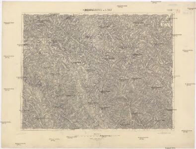
Medzilaborce a Lisko
1 : 75000 Medzilaborce (Slovensko : oblast) Vojenský zeměpisný ústav
Medzilaborce a Lisko
1 : 75000 Medzilaborce-oblast (Slovensko) Vojenský zeměpisný ústav
III. vojenské mapování 4268
1 : 75000
Lisko und Mezolaborcz.; Spezialkarte der osterreichisch-ungarischen Monarchie.
from Spezialkarte der osterreichisch-ungarischen Monarchie. Austro-Hungarian Monarchy. Militärgeographisches Institut.,
Lisko und Mezőlaborcz
1 : 75000 Bieszczady, Medzilaborce Geripp: Offiz. Schill u. Baumgarten. Terrain: Oberlt. Jonak Edl. v. Freyenwald und Zivilarb. Vogel
Lisko und Mezölaborcz
1 : 75000 Medzilaborce-oblast (Slovensko) Baumgarten K. u. k. Militärgeographisches Institut
[Gradkartenblatt]
1 : 25000 Polsko Vojenský zeměpisný ústav
[Gradkartenblatt]
1 : 25000 Medzilaborce-oblast (Slovensko) Vojenský zeměpisný ústav
Sanok 108, uit: Special-Karte von Mittel-Europa / nach amtlichen Quellen bearbeitet von W. Liebenow
1 : 300000 titelvariant: W. Liebenow's Mittel-Europa; Annotatie: Titel boven de bladen: W. Liebenow's Mittel-Europa Johannes Wilhelm Liebenow 1822-1897 Frankfurt a. M. : Ludwig Ravenstein

Normální mezinárodní letecká mapa.

Übersichtskarte von Mitteleuropa 1:300 000
1 : 300000 Levoča-oblast (Slovensko) Reichsamt für Landesaufnahme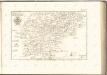


Brzozów und Sanok
1 : 75000 Polsko Irlanda K. u. k. Militärgeographisches Institut
Dukla-Pasz (Galizien).
from Spezialkarte der osterreichisch-ungarischen Monarchie.
[Gradkartenblatt]
1 : 25000 Medzilaborce-oblast (Slovensko) Vojenský zeměpisný ústav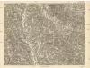
[Gradkartenblatt]
1 : 25000 Medzilaborce-oblast (Slovensko)
Brzozow und Sanok.; Spezialkarte der osterreichisch-ungarischen Monarchie.
from Spezialkarte der osterreichisch-ungarischen Monarchie. Austro-Hungarian Monarchy. Militärgeographisches Institut.,
Generalkarte von Zentraleuropa
Übersichtskarte des Kampfgeländes
1 : 650000 Polen Tarnów Weltkrieg <1914-1918> Verl. Gerhard Stalling, Oldenburg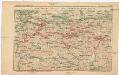
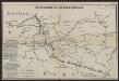
Strecke
Krakov (Polsko) K. k. Österreichische Staatsbahnen
Ost-Galizien
Halič (Polsko a Ukrajina) Liesganig, Joseph im Verlage des Kunst und Industrie Comptoirs
Východní Slovensko
1 : 300000 Banská Štiavnica (Slovensko) Fastr Eduard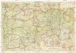
Východné Slovensko
1 : 300000 Banská Štiavnica (Slovensko) Edv. Fastr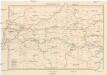
Galizien, Westlicher Theil
1 : 700000 Halič (Polsko a Ukrajina) Karl Fr. Pfau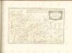
Mappa generalis regni Hungariae partiumque adnexarum Croatiae, Slavoniae...

Carte de la Roumanie et pays limitrophes. Cracovie
1 : 500000 France. Service géographique de l'armée [Paris] : Service géographique de l'armée
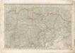
Krakau, Przemysl, Jaroslau, Kaschau, Leutschau
1 : 750000 Krakov (Polsko : oblast) Geng, K. K. u. k. Militärgeographisches Institut
Krakau, Przemysl, Jaroslau, Kaschau, Leutschau
1 : 750000 Krakov (Polsko : oblast) Geng, K. K. u. k. Militärgeographisches Institut
Krakau, Przemyśl, Jaroslau, Kaschau, Leutschau
1 : 750000 Jarosław (Polsko) R. Lechner