Maps of Sátoraljaújhelyi járás

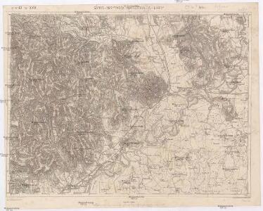
Sáros-Nagypatak und Sátoralja-Ujhely
1 : 75000 Maďarsko Bernhauer K. u. k. Militärgeographisches Institut
III. vojenské mapování 4667
1 : 75000
Čejkov a Sárosnagypatak
1 : 75000 Maďarsko Vojenský zeměpisný ústav
Slov. Nové Mesto a okolí
1 : 75000 Vojenský zeměpisný ústav
III. vojenské mapování 4667/4
1 : 25000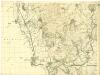
III. vojenské mapování 4667/2
1 : 25000
[Mapový list]
1 : 25000 Slovensko Vojenský zeměpisný ústav
[Gradkartenblatt]
1 : 25000 Slovensko Vojenský zeměpisný ústav
Saros-Nagypatak und Satoralja-Ujhely.
from Spezialkarte der osterreichisch-ungarischen Monarchie.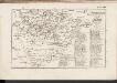
C. Zempliniensis. Tab. II
Slowakei Komitat Zemplín
Miskolcz 136, uit: Special-Karte von Mittel-Europa / nach amtlichen Quellen bearbeitet von W. Liebenow
1 : 300000 titelvariant: W. Liebenow's Mittel-Europa; Annotatie: Titel boven de bladen: W. Liebenow's Mittel-Europa Johannes Wilhelm Liebenow 1822-1897 Frankfurt a. M. : Ludwig Ravenstein
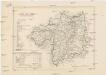
Zemplén vármegye térképe
1 : 470000 Zemplín (Slovensko a Maďarsko) Kogutowicz, Manó Magyar Földrajzi Intézet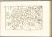

C. Abaujvár
Slowakei Ungarn Abaúj-Torna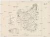
Szabolcser Comitat
1 : 280000 Szabolcs-Szatmár-Bereg (Maďarsko)
Szabolcser Comitat
1 : 280000 Szabolcs-Szatmár-Bereg (Maďarsko)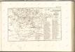

Abauj-Torna vármegye térképe
1 : 380000 Košice (Slovensko : oblast) Kogutowicz, Manó Magyar Földrajzi Intézet
Toketerebes und Nagyszalancz.
from Spezialkarte der osterreichisch-ungarischen Monarchie.
Goncz und Csobad (Ungarn).
from Spezialkarte der osterreichisch-ungarischen Monarchie.
Kaschau (Ungarn). Small #9918
from Spezialkarte der osterreichisch-ungarischen Monarchie.
[Mapový list]
1 : 25000 Slovensko Vojenský zeměpisný ústav
III. vojenské mapování 4567/4
1 : 25000
III. vojenské mapování 4567/3
1 : 25000
A bodrogkereszturi csata vazlata (1849 april 22- és 23-án)
Ungarn Bodrogkeresztúr Schlacht Ungarn / Revolution <1848-1849>
[Mapový list]
1 : 25000 Košice-oblast jižní (Slovensko) Vojenský zeměpisný ústav
C. Szabolcs
Ungarn Slowakei Komitat Szabolcs
Stolice Zemplín a Užhorod
Komitat Zemplín, Komitat Uschgorod, ethnische Gruppe
Stolice Zemplín a Užhorod
Užhorod (Ukrajina)
Comitat Abaúj-Torna
1 : 290000 Košice (Slovensko : oblast)