Maps of Neustift im Stubaital

Feuerstein
1 : 50000 Stubaiské Alpy (Itálie a Rakousko : pohoří) Deutscher und Oesterreichischer Alpenverein
Spezialkarte der Ostalpen

Solden und St. Leonhard (Tirol).
from Spezialkarte der osterreichisch-ungarischen Monarchie.
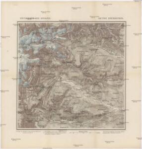
Otzthal.
from Spezialkarte der osterreichisch-ungarischen Monarchie.
Brenner-Bahn
1 : 96000 Bolzano (Itálie) Fr. Unterberger's Kunsthandlung
Nördl. Oetzthaler- und Stubaier Alpen, Nordwest. Kalkalpen
1 : 130000 Alpy rakouské (pohoří) Maschek, R. Meuer, Julius Artaria
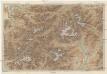
Nördl. Oetzthaler- und Stubaier Alpen, nordwest. Kalkalpen
1 : 130000 Meurer, Julius ; Maschek, R. Verlag Artaria & Co.
[Stubaier Alpen]
1 : 100000 Stubaiské Alpy (Itálie a Rakousko : pohoří) Freytag & Berndt
Carte du Tyrol
1 : 150000 West-Blatt Anich, Peter par le Dépôt Général de la Guerre
B.Z. - Karte von Oesterreich
Militair Karte von Süd-Deutschland in 20 Sectionen
1 : 400000 18. Section Coulon, Alois von A. von Coulon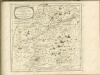

Meran
1 : 200000 1 Karte entworfen und bearbeitet von Woerl ; in Stein gestochen unter seiner Leitung ; Lithographie von B. Herder Herder, Freiburg im Breisgau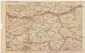
Strecke
Bludenz (Rakousko) K. k. Österreichische Staatsbahnen
Engadin-Orientbahn
1 : 250000 1:250 000 Schweiz Eidgenössisches Topographisches Bureau Eidg. Topographisches Bureau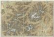
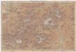
Karte der West - Tiroler und Engadiner – Alpen
Karte der West-Tiroler und Engadiner Alpen
1 : 250000 Engadin (Švýcarsko) Ravenstein, Ludwig L. Ravenstein
Vorarlberg - Oetzthaler Alpen - Brenner
1 : 850000 Bibliographisches Institut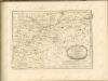

Generalkarte von Zentraleuropa
Karte der West-Tiroler und Engadiner Alpen
1 : 250000 Engadin (Švýcarsko) Ravenstein, Ludwig Geographische Anstalt von L. Ravenstein
Karte der West-Tiroler und Engadiner Alpen
1 : 250000 Ravenstein, Ludwig Geographische Anstalt von L. Ravenstein
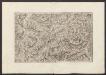
Tirolis
Mollova mapová sbírka Hoffmann, Johannes Hoffmann, Johann
Totius s.r.i. circuli Suevici tabula chorographica, 4
1 Blatt : R. et J. Ottens
Carte topographique d'Allemagne contenant une partie des Grisons, du comté de Tyrol, du comté de Pludentz, et le comté de Bormio
1 Karte fait par I. W. Iaeger chez l'auteur, Francfort sur le Mein
Atlas Tyrolensis
Mollova mapová sbírka Anich, Peter
Sect. 26: Augsburg, uit: Geologische Karte des Deutschen Reichs in 27 Blaettern / [von] Richard Lepsius ; Red. von C. Vogel
1 : 500000 Annotatie: Blad 18 ontbreekt; Een aantal bladen op linnen; Een aantal bladen gereviseerd 1913-1914; Annotatie geografische gegevens: Met schaalstokken o.a. in kilometers; Legenda Carl Vogel 1828-1897 Gotha : Justus Perthes