Maps of Bovec
Julische Alpen
1 : 50000 Julské Alpy (Itálie a Slovinsko : pohoří) R. Lechner
Julische Alpen

Flitsch.
from Spezialkarte der osterreichisch-ungarischen Monarchie.
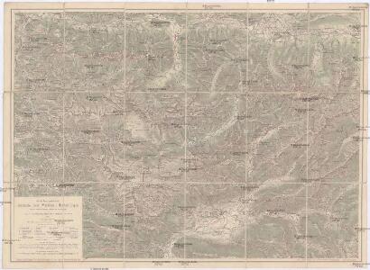
Nördliches Isonzogebiet
Isonzo-Gebiet Isonzoschlachten
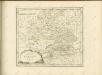
Ducatus Carnioliae Tabula Chorographica Iusu Sumptuque inclytorum Provinciae Statuum.
1 : 100000 Mollova mapová sbírka Florjančič de Grienfeld, Janez Dizma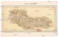
Audolj Rezianské
Resia (Itálie) Müller, Jos. D. Šafařík, Pavel Josef
Bartolo Sattel
1 : 25000 Kartographisches Institut
Comitatus Goritiae Et Finitima
1 : 115000 Mollova mapová sbírka Coronini, Rudolf Winkler, Johann Christoph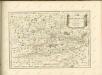

Trst
1 : 200000 Terst (Itálie) Kartografska radionica
Bleiberg und Tarvis.
from Spezialkarte der osterreichisch-ungarischen Monarchie.
Julijske Alpe
1 : 75000 Julské Alpy (Itálie a Slovinsko) Knafelc, Alojz Slov. Plan. društvo
Tarvis
1 : 75000 Kartographisches, früher Militärgeographisches Institut
Gailitz
1 : 25000 Kartographisches Institut
Der Goerzer Kreis und der Triester Kreis
1 : 260000 Gorizia (Itálie) Kindermann, Joseph Karl Junker, Christoph Franz Xaver Miller
Comitatus Goritiae et Gradiscae
1 : 216000 Mollova mapová sbírka Coronini, Rudolf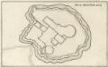
Gründt Riß der Statt Görtz
Mollova mapová sbírka Merian, Matthaeus Merian, Caspar
Comitatus Goritiae et Gradiscae cum limitibus Venetis et vicinia
1 : 220000 Benátky (Itálie) Coronini, Rudolf Quischae, D.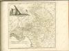

Oberkaernten oder der Villacher Kreis
1 : 250000 Korutansko (Rakousko) Kindermann, Joseph Karl Junker, Christoph Franz Xaver Miller
Oberkaernten oder der Villacher Kreis
1 : 250000 Korutansko (Rakousko) Kindermann, Joseph Karl Junker, Christoph Franz Xaver Miller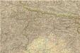
Carta d ́Italia speciale per Automobilisti

Le Frioul
1 : 278000 Furlandsko Santini, P. Remondini, M. M. Remondini
Carta topografica della provincia del Friuli
1 : 162000 Furlandsko Malvolti, Giuseppe Zuliani, Pietro
Aus der Übersichtskarte von Mittel-Europa 1:750 000
1 : 750000 Evropa střední K. k. Österreichische Staatsbahnen
Carta del Friuli tra i fiumi Livenza ed Isonzo
1 : 200000 Furlandsko Marinelli, Giovanni Taramelli, Torquato E. Passero
Il Friuli colla Carnia e Cadorino di nuova projezione
1 : 402000 Furlandsko Pitteri, Marco Alvise Antonio Zatta
Carta delle contee di Gorizia, di Gradisca, distetto di Trieste, e del Friuli Veneto
1 : 208000 Burgenland (Rakousko) Capellaris, Giann Antonio Tommasini