Maps of Hopfgarten im Brixental

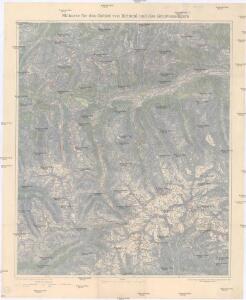
Skikarte für das Gebiet von Krimml und des Großvenedigers
1 : 50000 Salcburské Alpy (Rakousko : pohoří) Kartographisches Institut
Hippach und Wildgerlos-Spitze.
from Spezialkarte der osterreichisch-ungarischen Monarchie.
Rattenberg.
from Spezialkarte der osterreichisch-ungarischen Monarchie.
Zone 16, Kol. VI, Rattenberg, uit: Geologische Karte der im Reichsrathe vertretenen Königreiche und Länder der Österreich-Ungarischen Monarchie : auf Grundlage der Specialkarte i.M. 1:75.000 des k.u.k. Militär-geographischen Institutes / neu bearb. und als Kartenwerk von 341 Blattnummern in zwanglosen Lfg. hrsg. durch die k.k. Geologische Reichsanstalt in Wien
1 : 75000 titelvariant: Geologische Spezialkarte der im Reichsrate vertretenen Königreiche und Länder der Österreichisch-Ungarischen Monarchie; Geologische Specialkarte der im Reichsrathe vertretenen Königreiche und Länder der Österreichisch-Ungarischen Monarchie; Annotatie: Titel bovenaan kaartblad: Geologische Spezialkarte der im Reichsrate vertretenen Königreiche und Länder der Österreichisch-Ungarischen Monarchie en Geologische Specialkarte der im Reichsrathe vertretenen Königreiche und Länder der Österreichisch-Ungarischen Monarchie; Annotatie geografische gegevens: Coördinaten gebaseerd op nulmeridiaan van Ferro (Hierro) Kaiserlich-Königliche Geologische Reichsanstalt, Wenen Wien : K.K. Geologische Reichsanstalt
Special-Karte der Venediger-Gruppe
1 : 50000 Petters, Hugo ; Purtscheller, L. Deutscher und Oesterreichischer Alpenverein
Special-Karte der centralen Zillerthaler Gebirgsgruppe
1 : 50000 Zillertalské Alpy (Itálie a Rakousko : pohoří) Seyerlen, R. Daimer, J. Deutscher und Österreichischer Alpenverein
Der Ober-Sulzbach-Gletscher
1 : 5000 Vysoké Taury (Rakousko : pohoří) Richter, Eduard Deutscher und Österreichischer Alpenverein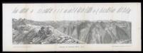
Panorama vom Speikboden 2519 m
Siegl, Julius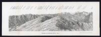
Panorama vom Speikboden 2519 m
Siegl, Julius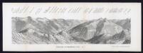
Panorama vom Speikboden 2519 m
Siegl, Julius
Prägraten
1 : 25000 Hauptvermessungsabteilung XIV
Hohe Fürlegg
1 : 25000 Hauptvermessungsabteilung XIV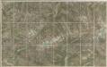
Zillerthaler Alpen

Touristen-Wanderkarte
1 : 100000 Benátské Alpy (Itálie) G. Freytag & Berndt
[Innsbruck und Umgebung]
1 : 250000 Innsbruck (Rakousko : oblast) Wagner & Debes
[Kitzbühel und Umgebung]
1 : 250000 Tyrolské Alpy (Rakousko : pohoří) Wagner & Debes
Spezial-Karte der Umgebung von Kitzbuhel
1 : 40000 Brunn, Oscar, cartographe 18..-19.. Munich : Verkehrsverein Kitzbuhel
Tyrolis sub Felici Regimine Mariae Theresiae Rom. Imper. Avg. Chorographice Delineata ...
1 : 104000 Mollova mapová sbírka Mansfeld, Johann Ernst Mansfeld, Johann Ernest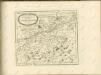

Tyrolis sub Felici Regimine Mariae Theresiae Rom. Imper. Avg. Chorographice Delineata ...
1 : 104000 Mollova mapová sbírka Mansfeld, Johann Ernst Mansfeld, Johann Ernest
Tyrolis sub Felici Regimine Mariae Theresiae Rom. Imper. Avg. Chorographice Delineata ...
1 : 104000 Mollova mapová sbírka Mansfeld, Johann Ernst Mansfeld, Johann Ernest
Tyrolis sub Felici Regimine Mariae Theresiae Rom. Imper. Avg. Chorographice Delineata ...
1 : 104000 Mollova mapová sbírka Mansfeld, Johann Ernst Mansfeld, Johann Ernest
Tyrolis sub Felici Regimine Mariae Theresiae Rom. Imper. Avg. Chorographice Delineata ...
1 : 104000 Mollova mapová sbírka Mansfeld, Johann Ernst Mansfeld, Johann Ernest
Tyrolis sub Felici Regimine Mariae Theresiae Rom. Imper. Avg. Chorographice Delineata ...
1 : 104000 Mollova mapová sbírka Mansfeld, Johann Ernst Mansfeld, Johann Ernest
Generalkarte von Zentraleuropa

Herzogthum Salzburg
1 : 3200000 Salcburk (Rakousko : oblast) bei Marco Berra
Salzburg und Berchtesgaden
1 : 4000000 Berchtesgaden (Německo)
Tirolis
Mollova mapová sbírka Hoffmann, Johannes Hoffmann, Johann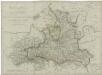
Herzogthum Salzburg