Maps of South Tyrol

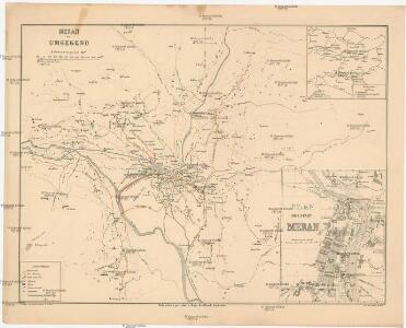
Meran und Umgegend
1 : 40000 Merano (Itálie : oblast) Knoblauch, Hugo S. Pötselberger
Meran und Umgegend
1 : 26000 Merano (Itálie : oblast) Bodenstein, Fr. Knoblauch, Hugo Lith. Anst. v. F. Köke
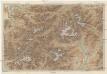
Übersichts- Karte Terrain-Curortes Meran-Mais
1 : 38000 Merano (Itálie) Oertel Fuchs F. C. W. Vogel
Karte der Umgebung von Meran
1 : 40000 Merano (Itálie : oblast) F.W. Ellmenreichs Verlag
Die Umgegend von Meran
1 : 210000 Merano-oblast (Itálie) Hartwig, E. von Brose, Heinrich Dietrich Reimer
Tyrolis sub Felici Regimine Mariae Theresiae Rom. Imper. Avg. Chorographice Delineata ...
1 : 104000 Mollova mapová sbírka Mansfeld, Johann Ernst Mansfeld, Johann Ernest
Umgebungskarte von Meran
1 : 75000 Merano (Itálie : oblast) K. u. k. Militärgeographisches Institut
Meran.
from Spezialkarte der osterreichisch-ungarischen Monarchie.
Uebersichtskarte des Oetzthaler Gletscher-Gebietes
1 : 144000 Ötztalské Alpy (Itálie a Rakousko : pohoří) Berghaus, Hermann Sonklar, Karl von Justus Perthes
Uebersichts-Karte des Oetzthaler Gletscher-Gebietes
1 : 144000 Sonklar von Innstädten, Carl ; Berghaus, Hermann Justus Perthes
Süd. Oetzthaler- und Ortler Alpen, Presanella Gruppe
1 : 130000 Ortles (Itálie : pohoří) Maschek, Rudolf Meurer, Julius Artaria
Carte du Tyrol
1 : 150000 West-Blatt Anich, Peter par le Dépôt Général de la Guerre
B.Z. - Karte von Oesterreich
Militair Karte von Süd-Deutschland in 20 Sectionen
1 : 400000 18. Section Coulon, Alois von A. von Coulon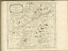

Trient
1 : 200000 1 Karte entworfen und bearbeitet von Woerl ; in Stein gestochen unter seiner Leitung ; Lithographie von B. Herder Herder, Freiburg im Breisgau
Drahtseilbahn Cortina-Belvedere
Cortina d'Ampezzo (Itálie) A. Dandrea
Meran
1 : 200000 1 Karte entworfen und bearbeitet von Woerl ; in Stein gestochen unter seiner Leitung ; Lithographie von B. Herder Herder, Freiburg im Breisgau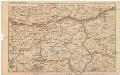
Strecke
Bludenz (Rakousko) K. k. Österreichische Staatsbahnen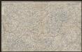
Engadin-Orientbahn
1 : 250000 1:250 000 Schweiz Eidgenössisches Topographisches Bureau Eidg. Topographisches Bureau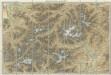
Karte der West - Tiroler und Engadiner – Alpen
Karte der West-Tiroler und Engadiner Alpen
1 : 250000 Engadin (Švýcarsko) Ravenstein, Ludwig L. Ravenstein
Vorarlberg - Oetzthaler Alpen - Brenner
1 : 850000 Bibliographisches Institut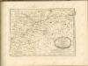

Generalkarte von Zentraleuropa

Tyrolis pars meridionalis
1 : 218000 Trident (Itálie : provincie) Spergs, Ioseph de Homannianis Hered.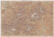
Karte der West-Tiroler und Engadiner Alpen
1 : 250000 Engadin (Švýcarsko) Ravenstein, Ludwig Geographische Anstalt von L. Ravenstein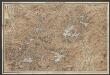
Karte der West-Tiroler und Engadiner Alpen
1 : 250000 Ravenstein, Ludwig Geographische Anstalt von L. Ravenstein
Tirolis
Mollova mapová sbírka Hoffmann, Johannes Hoffmann, Johann