Maps of Sölden

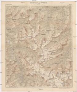
Oetzthal & Stubai
1 : 50000 Stubaiské Alpy (Itálie a Rakousko) Simon, S. Deutscher u. Oesterreichischer Alpen Verein
Oetzthal & Stubai
1 : 50000 Stubaiské Alpy (Itálie a Rakousko) Simon, S. Deutscher u. Oesterreichischer Alpen Verein
Oetzthal & Stubai

Oetzthal & Stubai

Oetzthal & Stubai
1 : 50000 Südwest-Blatt Simon, Simon Deutscher u. Oesterreichischer Alpen-Verein
Hoch Wilde
1 : 50000 Východní Alpy (pohoří) Haushofer, Karl Hoffmann, Carl J. Lindauer'sche Buchhandlung
Hoch Wilde
1 : 50000 Východní Alpy (pohoří) Haushofer, Karl Hoffmann, Carl Deutscher und Oesterreichischer Alpenverein
Meran und Umgegend
1 : 26000 Merano (Itálie : oblast) Bodenstein, Fr. Knoblauch, Hugo Lith. Anst. v. F. Köke
Timbler Joch
1 : 50000 Východní Alpy (pohoří) Haushofer, Karl Hoffmann, Carl J. Lindauer'sche Buchhandlung
Timbler Joch
1 : 50000 Východní Alpy (pohoří) Haushofer, Karl Hoffmann, Carl Deutscher und Oesterreichischer Alpenverein
Meran und Umgegend
1 : 40000 Merano (Itálie : oblast) Knoblauch, Hugo S. Pötselberger
Solden und St. Leonhard (Tirol).
from Spezialkarte der osterreichisch-ungarischen Monarchie.
Umgebungskarte von Meran
1 : 75000 Merano (Itálie : oblast) K. u. k. Militärgeographisches Institut
Skiroutenkarte der Ötztaler Alpen
1 : 50000 Ötztalské Alpy (Itálie a Rakousko : pohoří) Kuntscher, Karl Artaria
Karte der Umgebung von Meran
1 : 40000 Merano (Itálie : oblast) F.W. Ellmenreichs Verlag
Similaun
1 : 50000 Východní Alpy (pohoří) Haushofer, Karl Hoffmann, Carl J. Lindauer'sche Buchhandlung
Similaun
1 : 50000 Východní Alpy (pohoří) Haushofer, Karl Hoffmann, Carl Deutscher und Oesterreichischer Alpenverein
Übersichts- Karte Terrain-Curortes Meran-Mais
1 : 38000 Merano (Itálie) Oertel Fuchs F. C. W. Vogel
Die Umgegend von Meran
1 : 210000 Merano-oblast (Itálie) Hartwig, E. von Brose, Heinrich Dietrich Reimer
Uebersichts-Karte des Oetzthaler Gletscher-Gebietes
1 : 144000 Sonklar von Innstädten, Carl ; Berghaus, Hermann Justus Perthes
Carte du Tyrol
1 : 150000 West-Blatt Anich, Peter par le Dépôt Général de la Guerre
Uebersichtskarte des Oetzthaler Gletscher-Gebietes
1 : 144000 Ötztalské Alpy (Itálie a Rakousko : pohoří) Berghaus, Hermann Sonklar, Karl von Justus Perthes
Süd. Oetzthaler- und Ortler Alpen, Presanella Gruppe
1 : 130000 Ortles (Itálie : pohoří) Maschek, Rudolf Meurer, Julius Artaria
[Stubaier Alpen]
1 : 100000 Stubaiské Alpy (Itálie a Rakousko : pohoří) Freytag & Berndt
Nördl. Oetzthaler- und Stubaier Alpen, Nordwest. Kalkalpen
1 : 130000 Alpy rakouské (pohoří) Maschek, R. Meuer, Julius Artaria
Meran.
from Spezialkarte der osterreichisch-ungarischen Monarchie.
Nördl. Oetzthaler- und Stubaier Alpen, nordwest. Kalkalpen
1 : 130000 Meurer, Julius ; Maschek, R. Verlag Artaria & Co.
Brenner-Bahn
1 : 96000 Bolzano (Itálie) Fr. Unterberger's Kunsthandlung
Spezialkarte der Ostalpen