Maps of Balkan Pen.

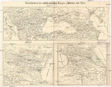
Uebersichtskarte des russisch-türkischen Krieges in Europa und Asien
Fuhrmbucher, M. Leopold Sommer
KARTE der europäischen Türkei und des Gebietes des schwarzen Meeres
1 : 3500000 Turecko Schneider, Theodor Kaiser, Josef Franz Jos. Fanz Kaiser
Karte der europäischen Türkei und des Gebietes des schwarzen Meeres
1 : 3500000 Turecko Schneider, Theodor Kaiser, Josef Franz
Geographische General Karte der Gränzen zwischen denen dreyen Kaiserthümern und ihren nach und nac
1 : 1400000 1 Karte : Kupferdruck ; 66 x 148 cm Maire, François Joseph [F. J. Maire]
Karte der europäischen Türkey nebst Theilen von Klein Asien, Russland und das Schwarze Meer
Evropa jihovýchodní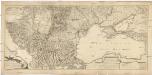
Geographische General Karte der Gränzen zwischen denen dreyen Kaiserthümern und ihren nach und nach geschehenen Veränderungen von Jahr 1718 bis heütigen Tags oder Kriegs Schauplatz gegenwärtigen Kriegs
1 : 1450000 Balkánský poloostrov Maire, Francois Joseph F.I.M.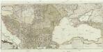
Geographische general Karte der Gränzen zwischen denen dreyen Kaiserthümern und ihren nach und nach geschehenen Veränderungen von Jahr 1718 bis heütigen Tags
1 : 1450000 Evropa jihovýchodní Maire, Francois Joseph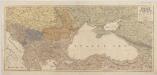
[Kaart], uit: Oorlogskaart van Turkije, Zuid-Rusland en grenslanden
1 : 2250000 Annotatie geografische gegevens: Legenda Amsterdam : Seyffardt's Boekhandel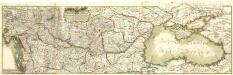
Illmo. et Excellmo. Domino Comiti Domino Ioanni Luca Pallavicino S.C.R.C.M. a Cubicul Aciei Generali Instructori unius Pedit: Leg:Tribun. Summo Rei navali Praefecto etc: etc
1 : 1300000 Mollova mapová sbírka Pujadies, Johann Baptist Heckenauer, Jakob Wilhelm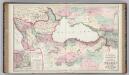
Vicinity of the Black Sea.
1 : 3787000 Gray, Ormando Willis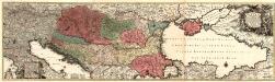
Tabula Synoptica Totius Fluminis Danubii
1 : 2000000 Mollova mapová sbírka Seutter, Matthäus Seutter, Matthäus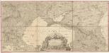
Carte de la partie septentrionale de l'Empire Otoman
1 : 1420000 osmanská říše Rizzi Zannoni, Giovanni Antonio Arrivet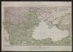
Kriegstheater Oder Graenzkarte Oesterreichs, Russlands, Und Der Türkey enthaltend Das Koenigreich Ungarn, Siebenbürgen, Moldau, Bessarabien, Walachey, Bulgarien, Servien, Bosnien, Sclawonien, Croatien, Albanien, Romanien, Macedonien, einen Theil Griechenlands, und des Archipelagus, die Dardanellen, das schwarze und asowische Meer, die Krim, Tatarey, Kuban, Circassien & & Nebt einem Theil von Russland, Polen, Schlesien, Maehren, Oesterreich, Steuermark &. ; C. Priv. S. C. M.
Schwarzmeer-Gebiet, Südosteuropa, Krieg Schütz, Carl ; Müller, Franz ;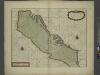
A sea chart of the Gulph of VENICE describing all the sea coasts and Islands contained therein
from The sea-atlas : containing an hydrographical description of most of the sea-coasts of the known parts of the world.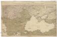
Kriegstheater oder Graenzkarte Oesterreichs, Russlands, und der Türkey
1 : 3000000 Balkánský poloostrov Schütz, C. Müller, Franz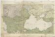
Kriegstheater oder Graenzkarte Oesterreichs, Russlands, und der Türkey
1 : 2950000 Evropa jihovýchodní Schütz, Carl Müller, Franz Artaria Compagnie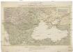
Kriegstheater oder Graenzkarte Oesterreichs, Russlands, und der Türkey
1 : 3000000 Balkánský poloostrov Schütz, C. Müller, Franz Artaria Compagnie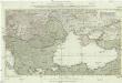
Kriegstheater oder Graenzkarte Oesterreichs, Russlands und der Türkey
1 : 3000000 Evropa jihovýchodní Schütz, C. Müller, Franz bey Artaria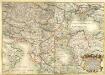
Accurate und Neüeste General Land-Karten Des dermahligen Türkischen Kriegs in sich haltent das Königreich Hungarn, Siebenbürgen, Walacheÿ, Moldau, Servien, Romanun, Pessarabien, die gantze Crim, ein Theil v. Pohlen, gantz Croatien, Bosnien, Dalmatien, Sclavonien, Morlachien, Ragusa, Albanien, Macedonien, gantz Griechen-Land, und ein grossen Theil von Asia
1 : 2300000 Mollova mapová sbírka Gruber, Ignaz Gruber, Ignaz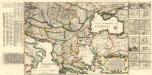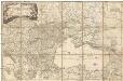
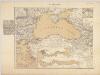
Carte de la Mer Noire comprenant la plus grande partie de l'Empire Otoman, partie des etats de l'Emperieur, de la Russie, & ca
1 : 2400000 Balkánský poloostrov Dezauche, Jean-André Dezauche
Orbis Romani descriptio, seu divisio per themata sub Imperatoribus Constantinopolitanis post Heraclii tempora facta
1 : 3800000
Carte des environs de la Mer-Noire où se trouvent l'Ukrayne, la Petite Tartarie, la Circassie, la G
1 : 2500000 1 Karte auf 2 Blatt : Kupferdruck ; 50 x 92 cm Robert de Vaugondy, Didier chez Delamarche rue du Foin près celle de la Harpe au collége de M.e Gervais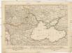
Kriegs Theater zwischen Russland und der Ottomanischen Pforte
Balkánský poloostrov Mollo, Tranquillo T. Mollo
Karta teatra vojny v Turcii v 1828 i 1829 godach
Balkánský poloostrov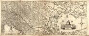
Neűe Ungarisch- und Türckische Grosse Land-Charte
1 : 2100000 Mollova mapová sbírka Hoffmann, Johann Pfann, Wilhelm Hoffmann, Johann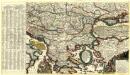
Mappa Generalis Danubii Principatum ab origine usque ejus influx um in mare nigrum
Mollova mapová sbírka Lidl, Johann Jakob
General Karte des Schwarzen Meeres mit den Karten des Bosporus und der Dardanellenstrasse
Das Schwarze Meer nebst Kriegsschauplatz in der europäisch. u. asiatisch. Türkei / von F. Handtke
1 : 2900000 titelvariant: Das Schwarze Meer; Annotatie geografische gegevens: Met schaalstokken Friedrich H. Handtke 1815-1879 Glogau : C. Flemming