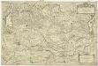
Maps of Lombardia
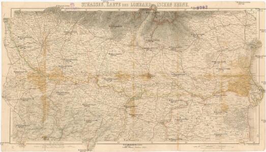
Strassen-Karte der Lombardischen Ebene
1 : 450000 Lombardie (Itálie) Justus Perthes
Cursus Fluminis Padi vel Po per Longobardiam a fonte usque ad Ostia
1 : 490000 Mollova mapová sbírka Cerutti, Agostino Homann, Johann Baptista - dědici
L'Etat de la Guerre Presente en Italie
1 : 530000 Mollova mapová sbírka Briffaut, Etienne Briffaut, Etienne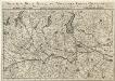
Theatrum Belli Italici
1 : 530000 Mollova mapová sbírka Leopold, Joseph Friderich Leopold, Joseph Friedrich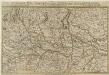
Theatrum Belli Italici. Anni 1701. Seu Novissima Tabula Geographica
1 : 530000 Mollova mapová sbírka Pauli, Georg Adam Joseph Engelbrecht, Christian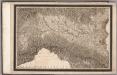
Northern Italy, by Giovanni Antonio Rizzi Zannoni
Rizzi Zannoni, Giovanni Antonio (1736-1814)
Special Charte des Herzogthums Mayland
1 : 536000 Lombardie (Itálie) Riegel, Christoph Christoph Riegel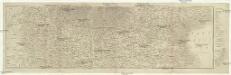
Nördliches Italien von Mailand nach Venedig
Benátky (Itálie) Schleich, C. Literar. artist. Anstalt
Ducatus Medioliani
1 : 523000 Lombardie (Itálie) Homann, Johann Baptist per Ioh. Bapt. Homannum
Belli typvs in Italia, victris Aquilae progreßus in statv Mediolanesi et dvcatv Mantvae demonstrans
1 : 530000 Itálie severní Homann, Johann Baptist per Io. Bapt. Homannvm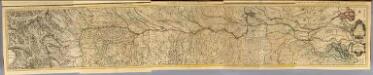
Composite: Cours du Po.
1 : 250000 Placide de Sainte Helene, Father

Ducatus Mediolanensis Parmensis et Montisferrati
1 : 500000 Mollova mapová sbírka Danckerts, Justus
Strassen-Karte des Lombardisch-Venezianischen Koenigreiches
1 : 432000 Lombardie (Itálie)
Ducatus Mediolanensis Parmensis et Montisferrati cum omnibus suis provinciis novissima descriptio
1 : 500000 1 Karte : Kupferdruck ; 46 x 56 cm Danckerts, Justus [Danckerts]
Carta della provincia di Mantova
Mantova-oblast (Itálie) Karacsay, F.
Specialkarte des Kriegsschauplatzes in der Lombardei
1 : 250000 Lombardie (Itálie) Handtke, Friedrich C. Flemming
Mailändische Feldzug
Mollova mapová sbírka Riegel, Christoph Riegel, Christoph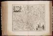
Dvcato di Modena regio et Carpi Col Dominio della Carsagnana
1 : 327000 titelvariant: Ducato di Modena regio et Carpi Col Dominio della Carsagnana; Annotatie: Origineel is Blad 161 in atlas factice; Annotatie geografische gegevens: Schaalstokken op de kaart: 12 Milliaria Italica communia (=6,1 cm), en: 3 Milliaria Germanica communia (=6,8 cm) Amstelodami : Apud Ioannem Ianssonium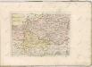

Jeziger Kriegs-Plan in Italien
1 : 525000 Mollova mapová sbírka
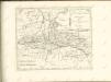
Les provinces du Veronese, du Vicentin du Padouan, de Polesine de Rovigo et du Dogado ou duché a la République de Venise, les duchés de Mantoue, de la Mirandole & c
1 : 270000 Benátky-oblast (Itálie) Jaillot, Alexis-Hubert H. Iaillot
Ducatus Mantuensis, in qua sunt ducatus Guas[ta]tae, principatuum Castiglionae Solverinae Bosolae et Sabbionettae nec non Mirandolae ducatus cum omnibus adjacentibus provinciis
1 : 290000 Mantova-oblast (Itálie) Danckerts, Justus per I. Danckerts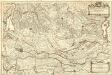
Les Provinces du Veronese, du Vicentin du Padouan, de Polesine de Rovigo et du Dogado ou Duché, a la République de Venise. Les Duchés de Mantoue, de la Mirandole &c.
1 : 260000 Mollova mapová sbírka Jaillot, Alexis-Hubert Jaillot, Alexis Hubert
Lombardia
1 : 250000 Lombardie (Itálie) Arrigoni, Ferdinando Artaria, Ferdinando Ferdinando Arrigoni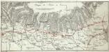
Viaggio da Milano a Venezia
1 : 1130000 Benátky (Itálie)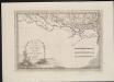
Lo Stato Veneto da terra diviso nelle sue provincie, terza parte che comprende il polesine e porzioni del Bresciano Veronese Vicentino Padovano e del Dogado
1 : 475200