Maps of Schleswig-Flensburg

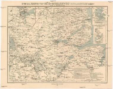
Special-Karte von Süd-Schleswig
1 : 150000 Šlesvicko Petermann, August Justus Perthes
Special-Karte von Süd-Schleswig
1 : 150000 Šlesvicko Petermann, August Friedrich Ehrlich
Special-Karte von Süd-Schleswig
1 : 150000 Šlesvicko Petermann, August Justus Perthes
PRÆFECTVRÆ | GOTTORPIENSIS | PARS AVSTRALIS.
Matthias und Clauss Peters. | Goldtschmide und gbr. sculp. Husumens. [Amsterdam : Joan Blaeu]
PRÆFECTVRÆ | GOTTORPIENSIS | pars Borealis.
Matthias und Clauss Petersen | Goldtschmide gebr. Hus. sculps. [Amsterdam : Joan Blaeu]
57. Rendsburg. (Germany)
1 : 100000 Reichsamt fur Landesaufnahme
Composite: 57. Rendsburg. (Germany)
1 : 100000 Reichsamt fur Landesaufnahme
TERRITORIA | ANGLEN | ET | SCHWANSEN | Anno 1649
Matthias und Clauss Petersen Goldtschmide und gebr. | Hus. Cimb. sculps. [Amsterdam : Joan Blaeu]
PRÆFECTVRA | FLENSBVRGENSIS | absque Nordgoeßherde.
Matthias & Nicolas Peters Goldtschmide | gebr. Husum. sculps. [Amsterdam : Joan Blaeu]
Praefectvra Flensbvrgensis absque Nordgoeßherde
1 : 110000 Mollova mapová sbírka Mejer, Johannes Peters, Matthias Blaeu, Joan I.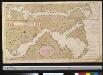
Afteekening van de Rivier van Sleeswijck waer bij dessefls incomen int grood wort vertoont geleegen in de Beldt
Germany Gerard van Keulen
38. Schleswig. (Germany)
1 : 100000 Reichsamt fur Landesaufnahme
Composite: 38. Schleswig. (Germany)
1 : 100000 Reichsamt fur Landesaufnahme
56. Husum. (Germany)
1 : 100000 Reichsamt fur Landesaufnahme
39. Kappeln. (Germany)
1 : 100000 Reichsamt fur Landesaufnahme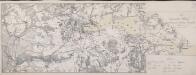
Die Dannewerks-Stellung
1 : 40000
Composite: 56. Husum. (Germany)
1 : 100000 Reichsamt fur Landesaufnahme
37. Bredstedt. (Germany)
1 : 100000 Reichsamt fur Landesaufnahme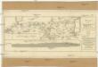
Plan des Holsteinschen Canals zwischen Rendsburg und dem Kieler Fiord nebst dessen Profil
1 : 125000 Kiel (Německo)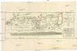
PLAN des Holsteinschen CANALS Zwischen Rendsburg und dem Kieler Fiord nebst dessen Profil
1 : 120000 Kiel (Německo)
Plan des Holsteinschen Canals zwischen Rendsburg und dem Kieler Fiord nebst dessen Profil
1 : 125000 Kiel (Německo)
SYLVA DANICA | vulgo | DÆNISCHEN WALDE.
[Amsterdam : Joan Blaeu]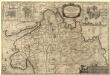
Dithmarsiae Pars Septentrionalis
1 : 75000 Mollova mapová sbírka Mejer, Johannes Peters, Matthias Blaeu, Joan I.
Composite: 39. Kappeln. (Germany)
1 : 100000 Reichsamt fur Landesaufnahme
58. Kiel. (Germany)
1 : 100000 Reichsamt fur Landesaufnahme
Composite: 58. Kiel. (Germany)
1 : 100000 Reichsamt fur Landesaufnahme
Plan des Schlachtfeldes von Schleswig
1 : 15000 [Schropp]
Plan des Schlachtfeldes von Schleswig
1 : 15000 [Schropp]
Meßtischblatt 426 : Gr. Flintbek, 1925
1 : 250000 Gr. Flintbek. - Aufn. 1877, kleine Nachtr. 1925. - 1:25000. - [Berlin]: Reichsamt für Landesaufnahme, 1925. - 1 Kt.