Maps of Vöcklabruck
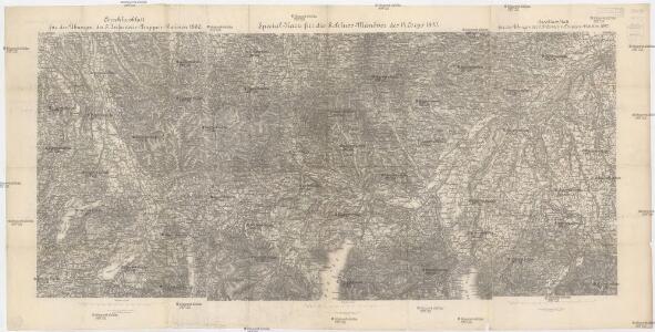
Special-Karte für die Schluss-Manöver des 14. Corps 1890
1 : 75000 Horní Rakousko (Rakousko) K. u. k. militär-geographisches Institut
Reid und Vocklabruck.
from Spezialkarte der osterreichisch-ungarischen Monarchie.
[Umgebungen von Ried]
David, J.
Bairische Landtafeln XXIIII. Darinnē das hochlöblich Furstenthumb Obern unnd Nidern Bayrn sambt der Obern Pflaz Erz unnd Stifft Salzburg Eichstet unnd andern mehrern anstossenden Herschafftē]
1 : 145000 Mollova mapová sbírka Apian, Philipp Amman, Jost Apian, Petrus
Archiducatus Austriae Superioris Geographica Descriptio. facta Anno 1667
1 : 150000 Mollova mapová sbírka Vischer, Georg Matthaeus Küssel, Melchior
Straszwalchen
1 : 25000 Kartographisches Institut
Steyrermühl
1 : 25000 Kartographisches Institut
Steyrermühl
1 : 25000 Horní Rakousko (Rakousko) Kartographisches Institut
Schörfling
1 : 25000 Horní Rakousko (Rakousko) Kartographisches Institut
Schörfling
1 : 25000 Hauptvermessungsabteilung XIV
Attersee
1 : 25000 Hauptvermessungsabteilung XIV
Gmunden und Umgebung
1 : 10000 Höller, Jakob E. Mänhardt
Frankenmart
1 : 25000 Kartographisches Institut
Richtberg
1 : 25000 Kartographisches Institut
Gmunden
1 : 25000 Gmunden (Rakousko) Kartographisches Institut
Richtberg
1 : 25000 Horní Rakousko (Rakousko) Kartographisches Institut
Seekirchen
1 : 25000 Hauptvermessungsabteilung XIV
Austriae Archiducatus Superioris in suas Quadrantes Ditiones exacte divisi accuratissima Tabula
1 : 330000 Mollova mapová sbírka Vischer, Georg Matthaeus Homann, Johann Baptista
Austriae Archiducatus Superioris in suas Quadrantes Ditiones exacte divisi accuratißima Tabula
1 : 330000 Mollova mapová sbírka Vischer, Georg Matthaeus Homann, Johann Baptista
Nova Mappa Archiducatus Austriae Superioris Ditiones in suas Quadrantes divisas conspectui listens iuxta recentissimas observation adornata
1 : 330000 Mollova mapová sbírka Seutter, Matthäus Seutter, Matthäus
Avstria Svperior secundum IIII. Quadrantes & regiones contiguas
1 : 330000 Mollova mapová sbírka Weigel, Christoph Seutter, Matthäus
Austriae Archiducatus Pars Superior in omnes ejusdem Quadrantes Ditiones accuratissime ét distincté delineata
1 : 330000 Mollova mapová sbírka Vischer, Georg Matthaeus Vischer, Peter
Salzburg
1 : 200000 Herder, Benjamin
Salzburg.
1 : 462000 Radefeld, Carl Christian Franz, 1788-1874
Pars IX. prodit partem Bavariæ sup: versus orientem et meridiem sitam ad Salam, Saltzam et Riv: Mattich, archiep: Salisburg. cum oris archiducat Austriæ super
1 Karte : 54 x 52 cm Heinrich Ludwig Broenner
Theil von Bayern
Bavorsko (Německo) Streit, Friedrich Wilhelm Geograph. Institut
Das Inn Viertel in dem Erzherzogthum Oesterreich ob der Enns
1 : 170000 Augsburg : Tobias Conrad Lotter
Umgebung von Gmunden, Ischl, Hallstadt, Aussee
1 : 129600 Ausseerland (Rakousko) Maschek, Rudolf Artaria
Archiducatus Austriae Superioris Geographica Descriptio. facta Anno 1667
1 : 150000 Mollova mapová sbírka Vischer, Georg Matthaeus Küssel, Melchior
Das Inn Viertel in dem Erzherzogthum Oesterreich ob der Enns
1 : 230000 Horní Rakousko (Rakousko) Balzer, Řehoř Anton Elsenwanger
Das Inn Viertel in dem Erzherzogthum Oesterreich ob der Enns
1 : 230000 Bavorsko (Německo) Balzer, Řehoř Anton Elsenwanger
Das Inn Viertel in dem Erzherzogthum Oesterreich ob der Enns
1 : 230000 Bavorsko (Německo) Balzer, Řehoř Anton Elsenwanger