Maps of Vyšší Brod

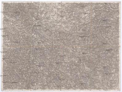
Hohenfurth und Rohrbach
1 : 75000 Vyšší Brod (Česko : oblast) K. u. k. Militärgeographisches Institut
III. vojenské mapování 4552
1 : 75000
Hohenfurth und Rohrbach
1 : 75000 Vyšší Brod (Česko : oblast) Fischer K. u. k. militär-geographisches Institut
Vyšší Brod a Rohrbach
1 : 75000 Rakousko Vojenský zeměpisný ústav
Vyšší Brod a Rohrbach
1 : 75000 Rakousko Vojenský zeměpisný ústav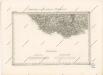
Special - Karte des Koenigreiches Boehmen

Podrobná mapa Království českého
1 : 100000 Dolní Vltavice (Černá v Pošumaví, Česko) Srp, Jan Jaroslav Bursík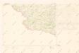
Mapy plánování ČSR
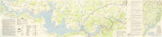
Lipenská přehrada

Topographische Karte der in Böhmen budweiser Kreises liegenden

Podrobné mapy zemí Koruny české v měřítku 1:75.000 a mapa vzdáleností všech míst při silnici ležících - Hor. Planá - Vyšší Brod. Průvodce statisticko-historický po všech místech na těchto mapách uvedených a rejstřík věcný názvů hor, potoků, řek, rybníků atd. Sešit 26. List 48,
1 : 75000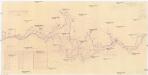
Zátopová plocha vodního díla Lipno
1 : 51600 Lipno (Česko : vodní nádrž : oblast)

[Gradkartenblatt]
1 : 25000 Horní Rakousko (Rakousko) Kartographisches Institut


III. vojenské mapování 4552/2
1 : 25000
[Gradkartenblatt]
1 : 25000 Lipno (Česko : vodní nádrž : oblast) Kartographisches Institut
[Gradkartenblatt]
1 : 25000 Lipno (Česko : vodní nádrž : oblast) Kartographisches Institut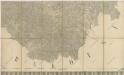
Nová mapa království Českého

III. vojenské mapování 4552/1
1 : 25000
III. vojenské mapování 4552/4
1 : 25000
Reiterschlag - c5640-2-012 - Kaiserpflichtexemplar der Landkarten des stabilen Katasters
1 : 2880
Reiterschlag - c5640-2-013 - Kaiserpflichtexemplar der Landkarten des stabilen Katasters
1 : 2880
Reiterschlag - c5640-2-008 - Kaiserpflichtexemplar der Landkarten des stabilen Katasters
1 : 2880
Reiterschlag - c5640-2-015 - Kaiserpflichtexemplar der Landkarten des stabilen Katasters
1 : 2880
Reiterschlag - c5640-2-007 - Kaiserpflichtexemplar der Landkarten des stabilen Katasters
1 : 2880
Reiterschlag - c5640-2-018 - Kaiserpflichtexemplar der Landkarten des stabilen Katasters
1 : 2880
Reiterschlag - c5640-2-010 - Kaiserpflichtexemplar der Landkarten des stabilen Katasters
1 : 2880
Reiterschlag - c5640-2-004 - Kaiserpflichtexemplar der Landkarten des stabilen Katasters
1 : 2880
Reiterschlag - c5640-2-002 - Kaiserpflichtexemplar der Landkarten des stabilen Katasters
1 : 2880
Reiterschlag - c5640-2-005 - Kaiserpflichtexemplar der Landkarten des stabilen Katasters
1 : 2880
Reiterschlag - c5640-2-020 - Kaiserpflichtexemplar der Landkarten des stabilen Katasters
1 : 2880
Reiterschlag - c5640-2-006 - Kaiserpflichtexemplar der Landkarten des stabilen Katasters
1 : 2880
Reiterschlag - c5640-2-016 - Kaiserpflichtexemplar der Landkarten des stabilen Katasters
1 : 2880
Reiterschlag - c5640-2-009 - Kaiserpflichtexemplar der Landkarten des stabilen Katasters
1 : 2880
Reiterschlag - c5640-2-001 - Kaiserpflichtexemplar der Landkarten des stabilen Katasters
1 : 2880
Reiterschlag - c5640-2-021 - Kaiserpflichtexemplar der Landkarten des stabilen Katasters
1 : 2880
Reiterschlag - c5640-2-019 - Kaiserpflichtexemplar der Landkarten des stabilen Katasters
1 : 2880
Reiterschlag - c5640-2-014 - Kaiserpflichtexemplar der Landkarten des stabilen Katasters
1 : 2880
Reiterschlag - c5640-2-017 - Kaiserpflichtexemplar der Landkarten des stabilen Katasters
1 : 2880
Reiterschlag - c5640-2-003 - Kaiserpflichtexemplar der Landkarten des stabilen Katasters
1 : 2880