Maps of Europe

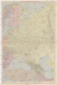
Ravensteinkarte Osteuropa
1 : 3333333 Evropa střední a východní Ravensteins Geographische-Verlagsanstalt und Druckerei
Russia Europea: Carta politica-administrativa della Russia dei Sovieti nell 1923
1 : 5000000 Istituto Geografico de Agostini di C. Rossi e A.M. Boroli Visintin, L.
TABVLA | RVSSIÆ | ex autographo, quod delineandum | curavit Foedor filius Tzaris Boris desum- | ta; et ad fluvios Dwinam, Zuchanam, aliaque | loca, quantum ex tabulis ex notitiis ad nos dela- | tis fieri potuit, amplificata...
Amstelodami, | Excusum Apud Guiljelmum Blaeu
Russia.
1 : 7760000 Johnson, A.J.
Russia.
1 : 7760000 Johnson, A.J.
Karte der Bevölkerung Russlands im 9. Jahrhundert
Russland Bevölkerungsdichte
European Russia.
1 : 8900000 Rand McNally and Company
Russian In Europe.
1 : 7603200 Fullarton, A. & Co.
Das europäische Rusland
Russland
Karte der Vergrösserungen Russlands unter Peter dem Grossen und seinen Nachfolgern
Russland Peter I.
Karte der Bevölkerung Russlands im 19. Jahrhundert
Russland Bevölkerungsdichte
Russia.
1 : 7760000 Johnson, A.J.
Russland
Russland / Europäischer Teil Skizzenbuch
Europäisches Russland
1 : 13300000 Russland / Europäischer Teil
Europäisches Russland
1 : 16000000 Russland / Europäischer Teil
Das europäische Russland
Schul-Atlas in 36 Karten Völter, Daniel Verlag der J.M. Dannheimer'schen Buchhandlung
Composite: Europaischen Russland.
1 : 5000000 Handtke, Friedrich H.
Tabula Russiae ex autographo, quod delineandum curavit Foedor filius Tzaris Boris desumta [...] [Karte], in: Theatrum orbis terrarum, sive, Atlas novus, Bd. 1, S. 67.
1 Karte aus Atlas Blaeu, Joan Blaeu, Willem Janszoon
Karte der Vergrösserungen Russlands unter Peter dem Grossen und seinen Nachfolgern
Russland Peter I.
Russland
1 : 16000000 Russland / Europäischer Teil
Ruszland
1 : 18000000 Russland / Europäischer Teil
Russland
Russland / Europäischer Teil
Wirtschaftskarten I. Rußland
1 : 18000000 Russland / Europäischer Teil Wirtschaft

Europaeisches Russland mit Kasan, Astrachan und Georgien
Russland / Europäischer Teil
Europaeisches Rusland
1 : 11800000 Asie západní Radefeld Bibliograph. Instituts
Praktische Geschäfts und Reisekarte sämmtlicher Staaten von Europa enthaltend die vorzüglichsten Strassen-Verbindungen mit Angage der Distanzen und der bestehenden Eisenbahnen: Nebst einem Theile von Africa u. Asien, und zwar die Länder: Marocco, Algerien u. Tunis, ganz Kleinasien, und ein Theil von Persien
Schulz, R. A.
Europaeisches Russland mit Polen
Geographischer Atlas über alle Theile der Erde Ziegler, Jakob Melchior Verlag von Dietrich Reimer
Russland
1 : 15225000 Russland / Europäischer Teil