Maps of Hungary

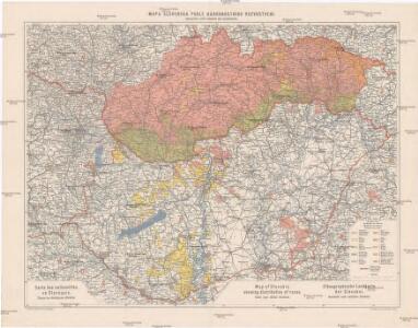
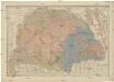
Mapa Slovenska podle národnostního rozvrstvení
1 : 750000 Slovensko Machát, František Vojenský zeměpisný ústav
Hungaria. [Karte], in: Gerardi Mercatoris Atlas, sive, Cosmographicae meditationes de fabrica mundi et fabricati figura, S. 412.
1 Karte aus Atlas Mercator, Gerhard Montanus, Petrus
Le Royaume d'Hongrie - Hungaria
Ungarn, Slowakei Briet, Philippe
Hungaria Regnum. [Karte], in: Le théâtre du monde, ou, Nouvel atlas contenant les chartes et descriptions de tous les païs de la terre, Bd. 1, S. 227.
1 Karte aus Atlas Blaeu, Willem Janszoon und Blaeu, Joan Blaeu, Willem Janszoon
Hungaria Regnum. [Karte], in: Theatrum orbis terrarum, sive, Atlas novus, Bd. 1, S. 105.
1 Karte aus Atlas Blaeu, Joan Blaeu, Willem Janszoon
HVNGARIA | REGNVM
Amsterdami | Apud Guiljelmum et Johannem Blaeu
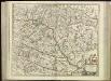
Totius Regni Hungariae una cum Adjacentibus et finitimis Regionibus Delineatio
Mollova mapová sbírka Visscher, Nicolaes Visscher, Nicolaus
Regnum Hungariae
1 : 2200000 Mollova mapová sbírka Bruggen, Johann van der Brugge, Johannes van der
Regnum Hungariae
1 : 2200000 Mollova mapová sbírka Pfeffel, Johann Andreas Pfeffel, Johann Andreas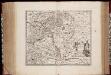
Novissima et accuratissima totius Hungariae tabula / par P. Du Val, geographe du Roij
1 : 1350000 Annotatie: Titel in het Latijn, auteursvermelding in het Frans, impressum en schaalaanduiding in het Nederlands; Origineel is Blad 131 in atlas factice; Annotatie geografische gegevens: Schaalvermelding boven schaalstok: Gemeene Duijtsche Mijlen van 15 in een graedt Pierre Du Val 1618-1683 't Amsterdam : gedruckt by Justus Danckers
Hungariae Regnum. [Karte], in: Novus atlas absolutissimus, Bd. 2, S. 285.
1 Karte aus Atlas Janssonius Offizin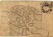
Hungary
1 : 860000 Mollova mapová sbírka Senex, John Senex, John

Ungarn und seine Nachbarländer 1919-1938
Ungarn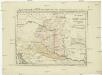
Postkarte von Nieder Ungarn, Kroatien und Sklavonien
Chorvatsko Kühn, Ignaz im von Reillyschen Landkarten und Kunstwerke Verschleiss Komptoir
Hungaria Regnum
Hungaria Regnum. [Karte], in: Gerardi Mercatoris et I. Hondii Newer Atlas, oder, Grosses Weltbuch, Bd. 1, S. 346.
1 Karte aus Atlas Mercator, Gerhard und Hondius, Jodocus Jansson, Jan
Hungaria in Partes II et Comitatus LII divisa
1 : 4300000 Mollova mapová sbírka Tomka Szászky, János
[80][80] Regnum Hungaria ..., uit: Atlas sive Descriptio terrarum orbis
Annotatie: Gedigitaliseerde versie. Amsterdam. Heiloo : Picturae (vervaardiger), 2015. tiff-bestand. Gedigitaliseerd: 07-01-2015; Origineel: Universiteitsbibliotheek Vrije Universiteit (XL.05127.-) ; Netherlands; Titelpagina ontbreekt Wit, Frederik de Amsterdam : Frederick de Wit
Hungary
1 : 1000000 Hongrie. S.G.A. le 20/12/19. In: Treaty Series No. 10.1920. Treaty of Peace between the Allied and Associated Powers and Hungary. June 4, 1920. War Office

Regnum Hungaria in Omnes suos Comitatus
Charte von den kaiserlich oesterreichischen ungarischen Ländern
1 : 1230000 Maďarsko Streit, Friedrich Wilhelm im Verlage des Geograph. Instituts
Ungarn und ein Theil von Siebenbürgen
Stieler's Hand-Atlas Stieler, Adolf bei Justus Perthes
Novissima regni Hungariae potamographica et telluris productorum tabula
1 : 991000 Maďarsko Junker, Christoph Joh. Matth. Korabinsky
Ungarn und ein Theil von Siebenbürgen
Hand-Atlas über alle Theile der Erde nach dem neuesten Zustande und über das Weltgebäude Stieler, Adolf bei Justus Perthes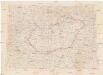
Hongrie
1 : 1000000 Maďarsko Senát Národního shromáždění