Maps of Volovets Raion

[Gradkartenblatt]
1 : 25000 Ukrajina
Smorze und Alsó-Verecke
1 : 75000 Transkarpatien Geripp: Assist. Pflügl. Terrain: Oberlt. Hettwer
III. vojenské mapování 4470
1 : 75000
Verecki a Smorze
1 : 75000 Ukrajina Vojenský zeměpisný ústav
Smorze und Also-Verecke.
from Spezialkarte der osterreichisch-ungarischen Monarchie.

C. Bereghiensis
Ungarn Ukraine Komitat Bereg
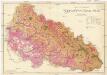
Comitat Beregh-Ugocsa
1 : 288000 Mukačevo (Ukrajina)
Comitat Beregh-Ugocsa
1 : 290000 Berehove (Ukrajina : oblast)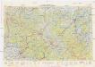
Neubertova generální automapa Republiky československé
1 : 200000 Soukup, Jan V. Neubert a synové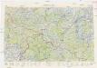
Neubertova generální automapa Republiky československé
1 : 200000 Soukup, Jan V. Neubert a synové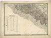
General-Karte des Königreiches Galizien und des Herzogthumes Bukovina
Podkarpatská Rus
1 : 225000 Podkarpatská Rus (Ukrajina) Gregor, František Novotný a Bartošek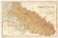
Podkarpatská Rus
1 : 225000 Podkarpatská Rus (Ukrajina) Gregor, František Novotný a Bartošek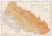
Podkarpatská Rus
1 : 225000 Podkarpatská Rus (Ukrajina) Gregor, František Novotný a Bartošek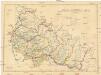
Podkarpatská Rus
1 : 300000 Podkarpatská Rus (Ukrajina) Referát min. veř. prací
Podkarpatská Rus
1 : 500000 Berehove (Ukrajina) Fastr Eduard
Slovensko

Podkarpatská Rus
1 : 300000 Berehove (Ukrajina) Fastr Eduard
Russia
Mollova mapová sbírka Hoffmann, Johannes Hoffmann, Johann
Ost Galizien
Halič (Polsko a Ukrajina) Liesganig, Joseph m Verlage des Kunst- und Industrie- Comptoirs
Ober Ungern
Rumunsko severní im Verlage des Kunst und Industrie Comptoirs
Ober Ungern
Rumunsko severní Ossenbrug, J. von Müller, Franz im Verlage des Kunst und Industrie Comptoirs
Vermehrte und Verbesserte Landkarten des Königreichs Ungarn :
1 : 500000 Mollova mapová sbírka Stier, Martin Böner, Johann-Alexander Endter, Martin
Nr. 6b. Kämpfe in Ostgalizien. Im Dnjestrgebiet
Galizien Weltkrieg <1914-1918>, Ostfront

A Tisavölgy vizszabályozasi átnézeti térképe
Augustissimo Romanor. Imperatori Iosepho I. Hungaria Regi Invictissimo Mappam Hanc Regni Hungariae
1 : 540000 Mollova mapová sbírka Müller, Johann Christoph
![[Gradkartenblatt]](https://images-2.georeferencer.com/images/iiif/408921493755/full/,300/0/native.jpg)

