Maps of gmina Ujsoły

[Gradkartenblatt]
1 : 25000 Orava (Polsko a Slovensko) Vojenský zeměpisný ústav
Ujsoly und Stara-Bistrica.; Spezialkarte der osterreichisch-ungarischen Monarchie.
from Spezialkarte der osterreichisch-ungarischen Monarchie. Austro-Hungarian Monarchy. Militärgeographisches Institut.,
Ujsoły und Stara-Bistrica
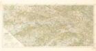
1 : 75000 Stará Bystrica, Schlesische Beskiden Schrift und Gerippe v. Dokaupil. Terrainschraffirung v. Hptm. R. Jonak Edl. v. Freyenwald
III. vojenské mapování 4262
1 : 75000
Borsod vármégye térképe
1 : 375000 Kogutowicz, Manó Magyar Földrajzi Intézet
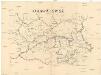
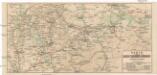
Stará Bystrica
1 : 75000 Orava (Polsko a Slovensko) Vojenský zeměpisný ústav
Stará Bystrica
1 : 75000 Slovensko Vojenský zeměpisný ústav
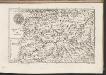
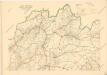
Ujsoły und Stara-Bistrica
1 : 75000 Polsko Dokaupil K. u. k. Militär-geographisches Institut
Saybusch.
from Spezialkarte der osterreichisch-ungarischen Monarchie.
Malá Fatra

Podrobná mapa Markrabství moravského a Vévodství slezského
1 : 100000 Istebna (Polsko) Srp, Jan Jos. R. Vilímek
[Gradkartenblatt]
1 : 25000 Orava (Polsko a Slovensko) Vojenský zeměpisný ústav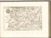
C. Arvensis
Slowakei Polen Komitat Arva

Stolice Orava a Liptov
Komitat Arva, Komitat Liptau, ethnische Gruppe
Das Fürstenthum Teschen in Ober-Schlesien
1 : 1170000 Těšínské Slezsko Schleuen, Johann David Schleuen
Trentschin 120, uit: Special-Karte von Mittel-Europa / nach amtlichen Quellen bearbeitet von W. Liebenow
1 : 300000 titelvariant: W. Liebenow's Mittel-Europa; Annotatie: Titel boven de bladen: W. Liebenow's Mittel-Europa Johannes Wilhelm Liebenow 1822-1897 Frankfurt a. M. : Ludwig Ravenstein
Orawa i Spisz
Orava (Polsko a Slovensko)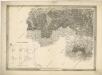
General-Karte des Königreiches Galizien und des Herzogthumes Bukovina

Comitat Trencsin
1 : 288000 Trenčín-oblast (Slovensko)
Comitat Trencsin
1 : 280000 Trenčín-oblast (Slovensko)
[Rechterblad], uit: Podrobná mapa Vysokých Tater
1 : 25000 Annotatie: Opname 1896/97, gedeeltelijk herzien 1931; Annotatie geografische gegevens: Inzet: Pérehled oblasti Tater. - 1:200.000 [Praag : Vojenský Zeméepisný Ústav]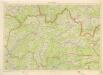
Kraj Žilinský
Bez titulu: mapy slovenských krajů

Kraj žilinský
Střední Pováží
Karte der Kaiser Ferdinands-Nordbahn
Brno-oblast (Česko) R. v. Waldheim
![[Gradkartenblatt]](https://images-2.georeferencer.com/images/iiif/139067510597/full/,300/0/native.jpg)

