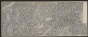
Maps of Alföld

Novissima et accuratissima totius Hungariae tabula
1 : 2300000 Evropa jihovýchodní Duval, Pierre Danckerts, Justus by Justus Danckers
Novissima et accuratissima totius Hungariae tabula
1 : 2300000 Maďarsko Duval, Pierre P. Du Val
Novissima et Accuratissima Hungariae Tabula In suas partes divisa J.U.M.
1 : 1700000 Mollova mapová sbírka
Tabvla Nova Inclyti Hvngariae
1 : 2000000 Mollova mapová sbírka Mikoviny, Sámuel Landerer z Füskutu, Ján Michal
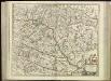
Hvngariae descriptio
1 : 3400000 Uhersko Lazius, Wolfgang Ortelius, Abraham A. Ortelius
Regni Hungariae cum adiuncta Transylvania aliarumq; terrarum confinijs Tabula
1 : 2600000 Mollova mapová sbírka Bruggen, Johann van der Brugge, Johannes van der
Regni Hungariae cum adiuncta Transylvania aliarumq; terrarum confinijs Tabula
1 : 2600000 Mollova mapová sbírka Pfeffel, Johann Andreas Pfeffel, Johann Andreas
Regni Hungariae cum adiuncta Transylvania aliarumq; terrarum confinijs Tabula
1 : 2600000 Mollova mapová sbírka Pfeffel, Johann Andreas
Hvngaria
1 Karte : Kupferdruck ; 35 x 43 cm Mercator; Hondius Henricus Hondius
Hvngaria
1 Karte : Kupferdruck ; 35 x 43 cm Mercator s.n.
Ungarn und ein Theil von Siebenbürgen
Hand-Atlas über alle Theile der Erde nach dem neuesten Zustande und über das Weltgebäude Stieler, Adolf bei Justus Perthes
Novissima et Accuratissima Totius Hungariae Tabula
1 : 1400000 Mollova mapová sbírka Duval, Pierre Danckerts, Justus
Ungarn und ein Theil von Siebenbürgen
Hand-Atlas über alle Theile der Erde nach dem neuesten Zustande und über das Weltgebäude Stieler, Adolf bei Justus Perthes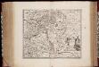
Novissima et accuratissima totius Hungariae tabula / par P. Du Val, geographe du Roij
1 : 1350000 Annotatie: Titel in het Latijn, auteursvermelding in het Frans, impressum en schaalaanduiding in het Nederlands; Origineel is Blad 131 in atlas factice; Annotatie geografische gegevens: Schaalvermelding boven schaalstok: Gemeene Duijtsche Mijlen van 15 in een graedt Pierre Du Val 1618-1683 't Amsterdam : gedruckt by Justus Danckers
Regnum Hungariae
1 : 2200000 Mollova mapová sbírka Bruggen, Johann van der Brugge, Johannes van der
Regnum Hungariae
1 : 2200000 Mollova mapová sbírka Pfeffel, Johann Andreas Pfeffel, Johann Andreas
Ungarn und ein Theil von Siebenbürgen
Stieler's Hand-Atlas Stieler, Adolf bei Justus Perthes
Hungariae Regnum. [Karte], in: Novus atlas absolutissimus, Bd. 2, S. 285.
1 Karte aus Atlas Janssonius Offizin
Uhry
1 : 1870000 Maďarsko
Uhry
1 : 1870000 Maďarsko
Uhry
1 : 1870000 Maďarsko
Hungaria in Partes II et Comitatus LII divisa
1 : 4300000 Mollova mapová sbírka Tomka Szászky, János
Regnum Hungaria in Omnes suos Comitatus

[80][80] Regnum Hungaria ..., uit: Atlas sive Descriptio terrarum orbis
Annotatie: Gedigitaliseerde versie. Amsterdam. Heiloo : Picturae (vervaardiger), 2015. tiff-bestand. Gedigitaliseerd: 07-01-2015; Origineel: Universiteitsbibliotheek Vrije Universiteit (XL.05127.-) ; Netherlands; Titelpagina ontbreekt Wit, Frederik de Amsterdam : Frederick de Wit
Ungarn, Siebenburgen, Slavonien, Kroatien.
1 : 1850000 Stieler, Adolf
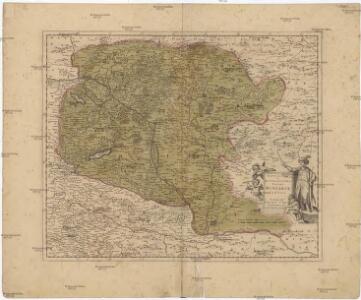
Serenissimo ac Potentissimo Hungariae Regi Josepho Primo
1 : 680000 Mollova mapová sbírka Colloredo, Fabius Antonius
Le Royaume d'Hongrie - Hungaria
Ungarn, Slowakei Briet, Philippe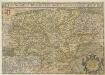
Hvngariae Descriptio
1 : 1400000 Mollova mapová sbírka Lazius, Wolfgang