Maps of Coast Mountains

CHARTE von der NORDWESTKÜSTE AMERICAS Nach Vancouver
Severní Amerika-oblast západní
Facsimile: Russian Explorations of Pacific and Icy Seas (portion).
1 : 6400000 Alaskan Boundary Tribunal
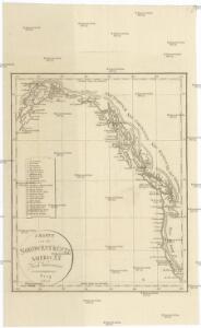
Chart of Part of the North West Coast of America.
1 : 6800000 La Perouse, Jean-Francois de Galaup, comte de, 1741-1788
Continuacion de los reconocimientos hechos En La Costa No. De America.
1 : 6500000 Espinosa y Tello, J.
Facsimile: Faden's Map North America (portion).
1 : 7280000 Faden, William, 1750?-1836
Cote N.O. de l'Amerique.
1 : 6600000 La Perouse, Jean-Francois de Galaup, comte de, 1741-1788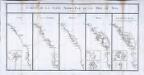
Carte de la coste nord-est de la mer du Sud
5 Karten auf einem Blatt : Kupferdruck ; je 38 x 17 cm, Bildgrösse 44 x 87 cm La Borde; Cook; Lapérouse; Dixon; Mears s.n.
Facsimile: Western Coast of America (portion).
1 : 5600000 Alaskan Boundary Tribunal
Facsimile: Part of Map of British North America. Arrowsmith.
1 : 9750000 Arrowsmith, John
Limits of forest trees
1 : 12500000 Kanada
British Columbia
1 : 2450000
Facsimile: Canada (portion).
1 : 12400000 Johnston, J.
Facsimile: Map of the Province of British Columbia.
1 : 4539000 Mohun, Edward
British Columbia.
1 : 2408000 Rand McNally and Company
Facsimile: Pacific Ocean Eastern Part (portion), Cape Corrientes, Mexico to Kodiak Island..
1 : 4970000 (Canadian?) Hydrographic Office
Facsimile: Pacific Ocean. Cook River to Gulf of California. British Admiralty Chart (portion).
1 : 4840000 British Admiralty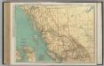
British Columbia.
1 : 2851000 Rand McNally and Company
Facsimile: Western Canada (portion).
1 : 7600000 Olgilvie, Wm.
Facsimile: Official British Columbia Map.
1 : 4500000 Selwyn, Alfred R.C.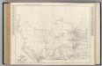
Alberta. British Columbia.
Rand McNally and Company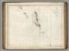
Chart of the North West Coast of America.
1 : 2660000 La Perouse, Jean-Francois de Galaup, comte de, 1741-1788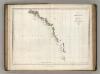
Chart of Part of the North West Coast of America.
1 : 2250000 La Perouse, Jean-Francois de Galaup, comte de, 1741-1788
Facsimile: Imray's North Pacific (portion).
Imray, James
Map Of The Grand Trunk Pacific Railway In British Columbia.
1 : 1250000 Grand Trunk Pacific Railway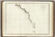
Cote N.O. de l'Amerique. 1.
1 : 3100000 La Perouse, Jean-Francois de Galaup, comte de, 1741-1788
Facsimile: Russian Map Numbered 5 (portion).
1 : 4925000 Alaskan Boundary Tribunal
Facsimile: British Columbia and Northwest Territory (portion).
1 : 5100000 Edward Stanford
Facsimile: Herbert's Colonial Manuscript Southern Alaska (portion).
1 : 3200000 Herbert, L., Senior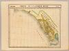
Partie, l'Amerique Russe. Amer. Sep. 23.
1 : 1641836 Vandermaelen, Philippe, 1795-1869